If you’re going to tackle a mountain, you might as well go for something substantial. Ben More – ‘The Big Mountain’ in Gaelic – ticks all the boxes for a challenge, but one that is achievable for experienced hill walkers.
Once, this lofty island peak was a mass of molten rock. Its igneous origins date back some 60 million years when the Isle of Mull was a major volcanic complex. Glaciers later shaped the mountain’s 966m summit.
Such is the reputation of Ben More that many Munro-baggers only attempt to climb it once they have scaled Scotland’s other 281 peaks over 3,000ft. Because of this status, it is often referred to as ‘the last Munro’. Getting there is something of an adventure in itself!
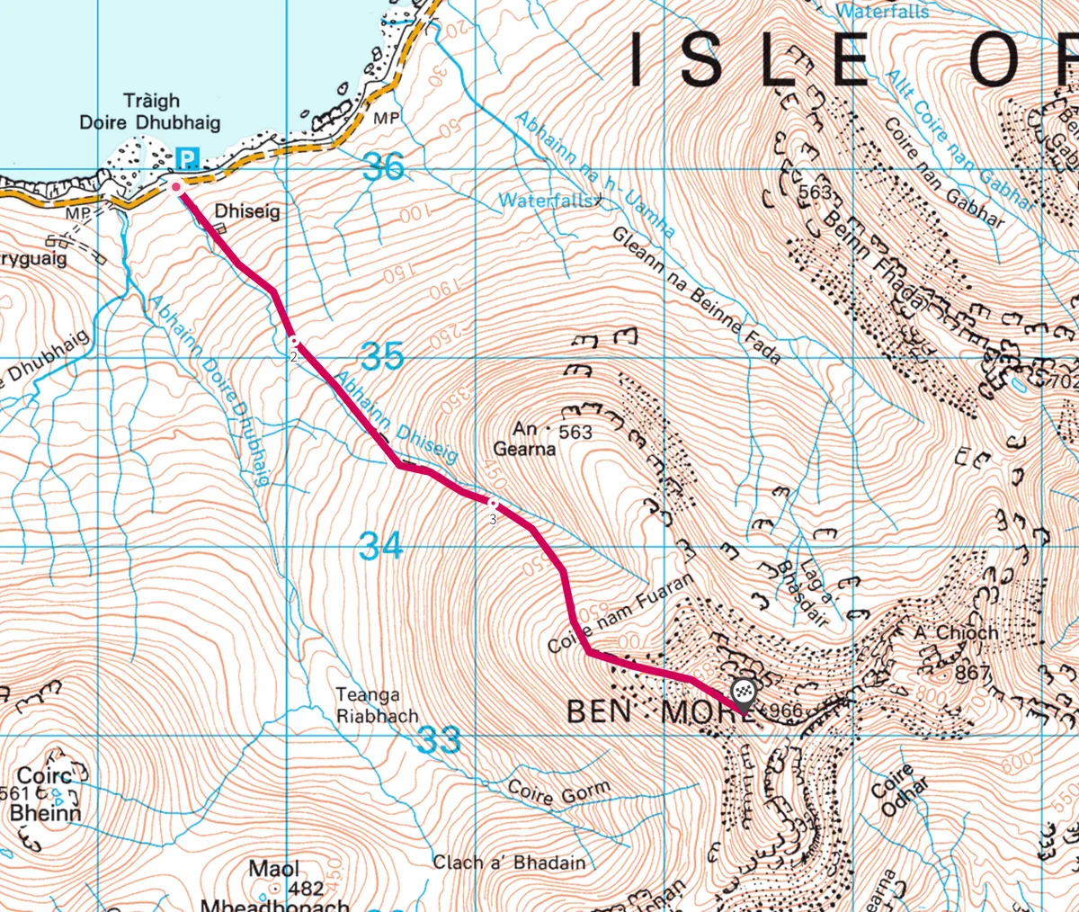
Catch the boat to Craignure, then head to the seaweed-strewn shores of Loch na Keal via the small village of Salen – stop at Mediterranea, a colourful and delicious Italian restaurant. Soon, if you’re lucky with the weather, the alarmingly long and steep profile of Ben More will hove into view. Park by Tráigh Doire Dhubhaig beach opposite a sign for Benmore Estate.

1
Bankside
Take the track up towards Dhiseig, a house in some trees, then where the track turns towards the house, continue uphill following the eastern side of the Abhainn Dhiseig river.
2
Icy remains
Take a moment to look behind you at the already expanding view. There’s the little island of Eorsa dead ahead and, further away, lying off the far side of the sea loch, is Ulva.
The land to the north is part of a specially protected site, and includes the summit of Ben More and the lichen and moss-rich woodlands of Scarisdale to the east. Down on the shoreline, the coast is scattered with glacier-scored rocks – these are the best-known examples of their type in Britain.
Higher up, the path crosses the burn and continues over grass to reach the bottom of a scree slope.
3
Magnetic mountain
The nature of the mountain now becomes distinctly more dramatic as the river rises from a deep chasm. The path trends south-south-east to lead up through boulders and is generally easy to follow. Be prepared for strong winds as the way increases in elevation. Higher up, veer east- south-east on Ben More’s western ridge proper – the scene is stunning, with views of Loch na Keal below scurrying clouds. To the left there are steep drops, so stick to the path, and be aware that the magnetic rock that forms much of the summit will interfere with the compass readings.

4
Island Zenith
The top of the Munro is marked by a circular stone shelter, the perfect spot to congratulate yourself on having walked all the way from sea level. The views from the isolated summit are magnificent in all directions. On a good day, you can see Ireland and Ben Nevis, along with many of the other Hebridean islands to the south, west and north.
Enjoy the descent back through the russet-coloured grasses of the lower slopes after a monumental day out on the Isle of Mull.
Map
Click on the map below for an interactive version of the route.