Surrounded by mountains, the Mawddach Estuary must be one of the most beautiful in Europe.
Wooden ships were built in its creeks before the arrival of the Great Western Railway, which connected with the Cambrian Coast at Morfa Mawddach. After operating for 100 years the line closed in the 1960s. Nowadays the former railway track between Morfa Mawddach and Dolgellau is used for walking and cycling and it provides a delightful walk on a crisp winter day.

Mawddach Estuary walk
9.5 miles/15.3km | 5-6 hours | moderate–challenging
1. On to the trail
From the Morfa Mawddach railway halt, join the Mawddach Trail and pass through a gate. Look out for flocks of siskins and finches feeding as you pass the Arthog Bog nature reserve; peat was once cut here. At a clear cross path, turn right through gates to the A493. Bear right for 150m then go left on a lane and, before Arthog Village Hall, turn left on a bridleway. Follow the path uphill, take the access track to a lane and turn right.
2. Seeing the past
After a farm, go left at an open space and between walls to a gate then cross a stone bridge over Afon Arthog. A few metres to your right are grass-covered banks which mark the remains of the medieval court Llys Bradwen.
You may also like:
Turn left along a path through a succession of gates for a little over 1km to a lane. Turn right and follow the lane down to the lake of Llynnau.
3. Wings up high
Just before reaching the lake, turn left at a footpath sign post. Ignore the left-hand path up Pared-y-Cefn hir, with its Iron Age hill fort, and with the hill on your left, stay on the main path, passing through remote heather moorland. Scan the sky for buzzards, peregrines and raven.

To your right is the Craig-las escarpment, an outlier of the Cader Idris range, which may carry a blanket of early winter snow. Further on, the path eventually descends to a ladder stile. Slant right through two wall gaps and follow a track to a lane. Turn left and take a path on the right downhill to rejoin the lane. Pass Kings Youth Hostel and stay on the road down to the A493. Because of the abundant mosses and lichens, this stretch of the Afon Gwynant is a Site of Special Scientific Interest.
4. Beyond the jetty
Emerge on the A493 and turn left. Soon turn right along Abergwynant Farm access lane and follow the river to a gate. Slant right to another gate and bear left to the Mawddach Trail. Turn left and after a ruined jetty, the ruins of a railwayman’s cottage are on your right. Pass an area of salt marsh with ditches and pools where waders feed and go through two gates to shortly rejoin your outward route. Retrace your steps to the start.
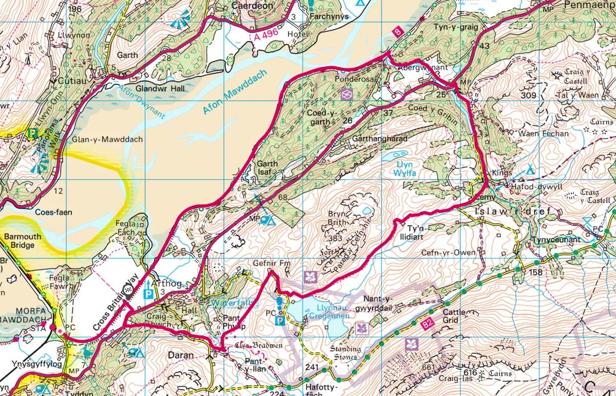
Mawddach Estuary map
Mawddach Estuary walking route and map
More information
TERRAIN
Level former railway track, bridleway, rough pasture, moorland and lane, with a moderate climb to Llynnau Cregennen. The Mawddach Trail is accessible to wheelchair users.
HOW TO GET THERE
By car: From the A493, seven miles southwest of Dolgellau, take the signposted road to Morfa Mawddach railway halt. The car park is nearby.
By public transport: Morfa Mawddach is on the Cambrian Coast Machynlleth-Pwllheli railway line.
REFRESHMENTS
George III Hotel Penmaenpool, Gwynedd LL40 1YD
01341 422525
TOURIST INFO
Dolgellau Tourist Information Centre – Ty Meirion, Eldon Square, Dolgellau LL40 1PU
01341 422888