Don’t let its proximity to the M6 fool you into thinking that this is a well-used tourist circuit. Once you leave behind the ancient market town of Sedbergh and climb to reach the heights of Brant Fell, at more than 190m (600ft) above sea level, you will find yourself in a stunning but isolated landscape that’s well and truly off the beaten track.
The route starts from the centre of Sedbergh, a delightful market town that is situated at the confluence of four valleys and four rivers, and where ancient trading routes met. Over the centuries the town’s main industries have been based largely around sheep farming and the manufacture of woven and hand knitted products.
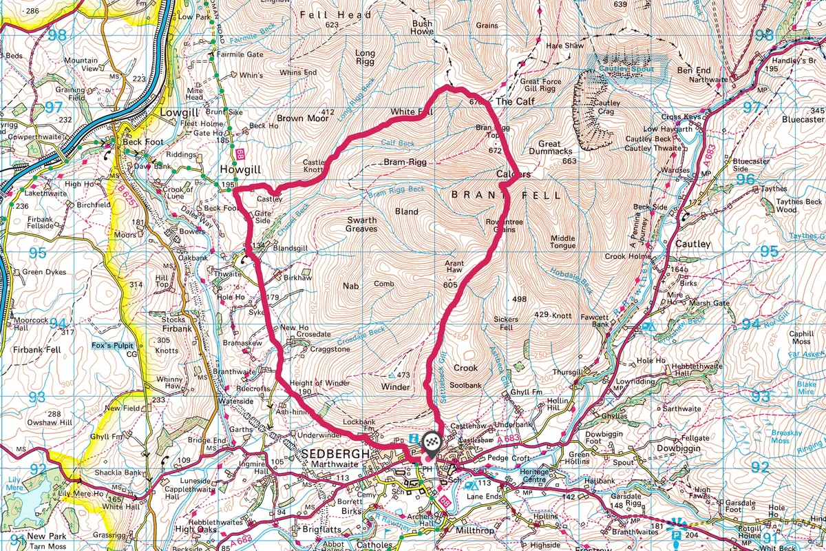
Follow this challenging walking route in the north-western corner of the Yorkshire Dales beginning in the village of Sedbergh and climbs into Howgill Fells with views west over the Cumbria landscape and east over North Yorkshire.

More recently tourism has become increasingly important to the local economy. In 2005 the future of the town was given a shot in the arm with the start of a four-year project to make Sedbergh England’s Book Town – a loose collective of businesses based around books and their production – and this project has really re-energised the town.
Howgill Fells walk
9.6 miles | 7–8 hours | Challenging
1. Sedbergh
From the centre of Sedbergh, head north up Howgill Lane out of town. The start of the route is a great tarmac section to get the thighs warmed up in preparation for the forthcoming climb. Continue along the lane for 1¼ miles until a T-junction and right-hand bend with Slacks Lane off to the left.

2. Howgill Lane
Continue along Howgill Lane for another 1¾ miles, until you reach a staggered crossroads.
3. The Calf
Take a right here and head up to Castley Farm. Follow the track past the two farms and enjoy a brief respite from the climb, travelling on to the bridleway and down in to Calf Beck. This is the start of a 500m climb. Cross the streams at their junction and climb up White Fell. Hook a right at the top and head up to the trig point at The Calf.

4. Settlebeck Gil
Take a well-earned rest at the top and enjoy the views of the Lakes to the west and the Yorkshire Dales three peaks to the southeast.
Continue along to Bram Rigg Top and Calders, then right and start the downhill. After nearly 8 miles into the ride, take the second track left to keep high on the side of Settlebeck Gill. Follow this track to Lockbank Farm, join the tarmac and head back to the town centre.
Howgill Fells map
Howgill Fells walking route and map