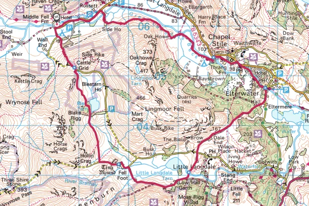
This circular walk starts with a short, sharp climb, but the route soon levels out, skirting the foot of Side Pike before slowly descending into Little Lansdale.
Looking for more walks in the Lake District? Check out our mapped routes at Tarn Hows, Cat Bells and Helvellyn.
Lingmoor Fell walk
8.3 miles / 13.5km | 5.5 hours | moderate | 362m ascent
1. Old Dungeon Ghyll
Park at the pay and display car park at that legendary hiker’s inn the Old Dungeon Ghyll and walk back to the end of the driveway to the T-junction.
Follow the track through the National Trust campsite, then take the footpath to the right, over a bridge, through a kissing gate and into the woods. Climb up through the wood, through another kissing gate and then out onto the lower slopes of Side Pike.

2. Side Pike
Continue parallel to the road to a ladder stile at the top of the pass then descend the rocky path through quite craggy terrain for half a mile or so to reach a gate on the edge of a conifer plantation. Blea Tarn comes into view on your left and the path skirts the edge of this pretty body of water where the woods meet the shoreline.
Keep a lookout for red squirrels up in the trees and carry on to the SW corner of the tarn, then follow the beck as it descends quite steeply via a series of waterfalls through a craggy gulley for around 200 yards until the beck falls away left into an innaccessible cleft. Cross the tributary and veer gradually right across the boggy ground towards the Ting Mound – site of an ancient Elders’ meeting place.

3. Low Fell
Join the unfenced road and turn left downhill, winding up at Fell Foot Farm. Follow the road as it winds right and then left around the farm and take the little stone bridge on the right. Cross the bridge over the River Brathay, passing Bridge End Farm before climbing gently up a track skirting the base of Low Fell below the quarries at Tilberthwaite.
From here the view over your shoulder encompasses Little Langdale Tarn back up Wrynose and Little Langdale to Cold Pike, with the Langdale Pikes pearing through the gap between Blake Rigg and Side Pike.

4. Elterwater
The path heads up a steep little knott just before turning left along the lane to a junction with the main road.
Cross the main road and take the track past Dale End Farm, descending through a gate into the woodland. Stay on the track until it joins the B5343 Langdale Road on the outskirts of Elterwater, where a short detour to warm up in the cosy snug of the Britannia Inn may be in order
Follow the track round the corner of the tarn and follow the Brathay down to Slater's Bridge.

5. Chapel Stile
From Elterwater, pick up the track running along the western bank of the Langdale Beck and follow it upstream, crossing a wooden footbridge which ends up virtually in the beer garden of Wainwright's Inn at Chapel Stile. Continue along the Cumbria Way through Bays Brown campsite, past Thrang Farm.
6. Langdale Pikes
Roughly follow the course of the beck along its southern bank, head back up Langdale, admiring the constantly changing vistas of the Langdale Pikes up ahead.
Lingmoor Fell map
Lingmoor Fell circuit walking route and map