Northumberland’s Upper Coquetdale is physically and historically one of the wildest parts of England.
The river rises in soggy ground, hard against some of the bleakest stretches of the Scottish border. In the middle reaches of the valley, a forested arc between the villages of Holystone and Alwinton encloses a tall, sandstone crag that guards Rob Roy’s Cave, where the outlaw is said to have hidden from his enemies. Whether he ever did is debatable, but this minor inconvenience did not deter Sir Walter Scott in his search for a good story.

In 1817, Scott booked into the Rose and Thistle, then a coaching inn, in Alwinton while he researched and wrote much of his popular novel, Rob Roy. The hero of the story, Frank Osbaldistone, travels from London to his uncle’s estate in Northumberland. On his journey, he meets Rob Roy, who is an associate of his uncle, both Jacobite sympathisers. The early chapters of the book are set around Osbaldistone Hall, which Scott based on the Georgian style Biddlestone Hall, some three miles north-east of Alwinton. The hall was demolished in the 1950s, leaving only the family chapel, now a Grade II listed building. The Selby family of Biddlestone shared the Catholic faith and Jacobite leanings with the fictional Osbaldistones of Scott’s novel. Following family intrigues, Frank continues into Scotland, again meeting Rob Roy prior to the 1715 Jacobite Rising, before returning to inherit the family estate.
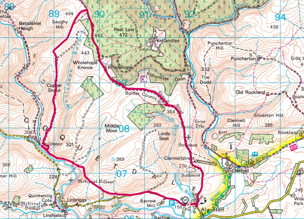
Follow this eight-mile walk over the broad grassy ridgelines, steep-sided valleys and ancient droving routes of Northumberland’s Cheviot Hills, Upper Coquetdale.
1
Driving north
If the historical Rob Roy ever brought cattle, legally or illegally across the border, he would almost certainly have done so via Clennell Street, an old drover’s road running north from Alwinton. You can still follow this broad, gently rising track for three miles to its high point near Saughy Hill, from where you can see the Scottish border occupying the northern skyline.

2
A drink to Rob Roy
You could return by the same route, or extend your walk to eight miles by dropping into the valley along the grassy ridge of Copper Snout. Detour left to Wholehope Burn and the remains of an illicit 18th-century whisky still – this may well have sustained Rob Roy on his travels.
3
East bound end
At Shillmoor, follow the Pass Peth path east, soon arriving back at Alwinton.
Map
Click on the map below for an interactive version of the route.