The fell sandstones of the Simonside Hills were deposited from a river delta some 330 million years ago. Weathering and erosion have led to their dominant aspect, which makes them recognisable throughout the county.
Their spiritual significance to the Bronze Age people, 5000 years ago, is evident in the burial tombs and rock carvings that adorn the slopes and summits. The blanket peat bog is an important carbon store and a habitat for plants such as cranberry, bog asphodel, butterwort and cross-leaved heath. It is also home to adders and red grouse.

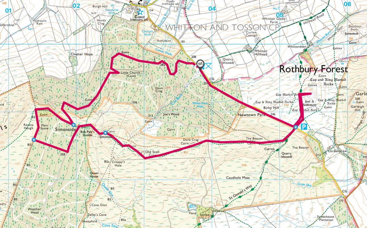
1. Church Rock
Follow the forest roadway gently uphill from the car park. At the first junction, take the right fork, past a communications tower, and on to the next fork, where you go left. A signpost indicates the proximity of Little Church Rock, which is worth the short detour to examine the cup markings that decorate its base. Back on the main trail, carry on to a bend where a rough track leads up to the left. Follow this through trees to more open moorland and a first sight of the wind-sculpted Simonside Crags on the left.
2. Forest Ramble
At the edge of the next section of forest you will come to another rubble road. Turn right on to this and follow it to its end, where it breaks into three footpaths. The middle path leads to a stile at the corner of the forest. Cross this and continue for about 200m to a cairn. About 50m to the right of this is the Ravensheugh escarpment and one of the finest views in the whole National Park, across rock pinnacles, towards the Coquets and Cheviots.

3. Out of the forest
Return to the stile. Take the track that runs between the wire fence and the forest, past a huge boulder and on to a break in the forest. Follow this gently downhill to another rubble road, turn left and carry on to a junction at the forest edge. Turn right and then ascend the rough, bouldery track that leads steeply past the crags to Simonside summit and another fine viewpoint, this time extending as far east as the coast.
4. Crag to crag
A series of stone slabs lead eastward across the bog to the wonderfully contorted summit of Old Stell Crag, crowned by a large cairn that itself stands on top of an ancient stone barrow. A mud track cuts down to a broader footpath, which leads over Dove Crag and The Beacon before making a final descent to the metalled road and Lordenshaws car park.

Final ascent
Follow the track that runs from the northern side of the car park. This leads to a hilltop occupied entirely by the remains of a Bronze Age settlement. A short distance below this is a large boulder decorated with ancient carvings. Return to the road and follow this for a mile back to the start.
Map
Simonside Hills walking route and map.
Useful Information
Terrain
Forest rubble road and mountain footpaths – rough and sometimes muddy underfoot. Boots and waterproof/windproof clothing are necessary.
How to get there
By car: Take the B6344 into Rothbury, turn south over bridge and immediately right on to the road past Witton and Great Tosson farms. Then take the sharp left at Great Tosson on to a narrow road, which leads to the forest car park.
By public transport: Frequent bus services run to Rothbury from Newcastle, Morpeth and Alnwick. On foot from Rothbury adds about 4 miles to the return walk.
