St Mary’s Island, marking the northern limit of Tyne and Wear, is only an island at high tide. At other times it is surrounded by an extensive rockpool wonderland in which whelks, winkles, sea anemones and hermit crabs abound.
This bike ride takes you to the white lighthouse, built in 1898 to replace an older one at Tynemouth Castle. It is no longer used as such, but houses a small museum and offers panoramic views over the coastline – if you’re prepared to climb the 137 steps.

1. Sandy beaches
A causeway links the island to our starting point – a car park at Curry’s Point, so named after the murderer Michael Curry, hung here in 1739 for killing the landlord of the nearby Three Horseshoes Inn. A plaque marks the spot.
Take the road past a small nature reserve and on to the A193 road along the coast. Follow this for a short distance before turning left onto the Whitley Bay promenade. This takes you past the long and very inviting sandy beach and prominent Spanish City, built in 1910 as the setting for a permanent fairground. Though the fair has now gone, it remains a Grade-II listed building for its early use of reinforced concrete and striking domed ceiling.
Continue past the former fishing village of Cullercoats, its harbour and Long Sands beach, another broad strand that is a favourite of surfers, then around the headland guarded by Tynemouth Castle. Built as a Benedictine monastery in 1090, the site, now owned by English Heritage, was fortified by Edward I in 1296, and remained in military use until 1960.
Related articles
2. Down to the river
Descend to the northern bank of the River Tyne, beneath the gaze of a statue of local hero, Admiral Lord Collingwood, who led the British fleet into battle at Trafalgar. The base is adorned by four canons from Collingwood’s ship,
Pass the North Shields Fish Quay and a variety of fish and chip restaurants, and carry on to the ferry terminal, which brings you across the river to South Shields.
3. Across the Tyne
On leaving the ferry, the main route moves south, past two roundabouts to a car-free section, which runs for almost a mile before turning right to join the A183 road.
An alternative route follows the riverside north, through residential and small-scale marine industrial areas to the mouth of the Tyne at South Groyne. It then turns south-east along the sea front, past the bustling Ocean Beach Pleasure Park, which boasts all the family-friendly attractions of a permanent fairground: rollercoasters, shark island, a pirate ship, roundabouts and kiosks selling fast food and ice cream.

4. Beacon in the dark
In complete contrast, the next two miles run along The Leas, a National Trust-maintained flower-rich grassland that drops over spectacular magnesian limestone cliffs to a stony beach, complete with smugglers’ caves. Beyond are sea stacks, the largest of which, Marsden Rock, is populated by thousands of pairs of kittiwakes, cormorants, guillemots and fulmars. You can reach the unique Marsden Grotto by a lift from the road and take refreshments in the cavern bar, hewn out of the cliff itself. It is said to be haunted by the ghosts of smugglers, so keep your eyes peeled.
A cliff-top ride of a further ½ mile brings you to the red and white rings of Souter Lighthouse. Built in 1871, this was the first in the world to be powered by AC electricity. Before its construction, this coast was responsible for more shipwrecks than any other comparable stretch in Britain. Decommissioned in 1999, the lighthouse is now owned by the National Trust, and has an engine room, Victorian keeper’s cottage and fascinating historical displays that are well worth a visit.
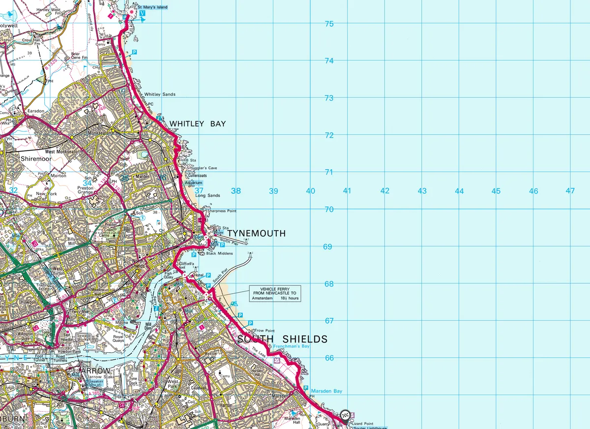
Map
Click on the map below for an interactive version of the route.
Useful Information
HOW TO GET THERE
By car, take the A1058 from Newcastle to the A193 at Cullercoats. Or, by public transport take Tyne and Wear Metro (folding cycles only) to Whitley Bay or Monkseaton, both two miles from the start.
FIND OUT MORE
Sustrans
www.sustrans.org.uk
Check the website for cycle routes.
STAY
The Little Haven Hotel River Drive
River Drive, South Shields
NE33 1LH
www.littlehavenhotel.com
0191 4554455
Beautifully situated on a beach at South Groyne.

