Rocks stipple the blackened slopes of Mynydd Dinas, a high point of the Preseli Hills, surrounded by gorse, rough pasture, stone walls and the teal waters of St George’s Channel.
This is a place of megalithic significance, huddled between the deep Gwaun Valley and the coast; a place where, to the song of a stream, a sinuous lane rises, ducks beneath ash trees, twists between hedges and delivers you to Dyffryn Fernant.
The garden belongs to this landscape. It’s a conversation with the rocks, the tussocky bog and the blue clay from which it has been coaxed. Bold exotics are accommodated among natives that creep and drift in by rhizome and seed.
Explore these pretty Welsh gardens in Pembrokeshire Coast National Park then step into the hills for a seven-mile loop walk.

Most poignantly, it is a place of power and pause beneath the omnipresent contemplation- demanding gaze of Garn Fawr, the largest rocky outcrop on the Mynydd Dinas summit.
Visitin Dyffryn Fernant garden
But before the reflection comes excitement: the blaze of azaleas in the carpark; the thrill of turning one bend and then another to meet head-on the raspberry-sorbet-coloured farmhouse festooned in roses and creepers, rising riotously from an Impressionistic blitz of colour. Dahlias, agapanthus and geraniums sprout from pots and peep from between boulders, sculptures and mossy stone walls, dancing with the sun.
Yet even here, among this dazzle and glee, water slips imperceptibly over the bevelled surface of a battered old brandy still, adrift with quiet reflected nuances of sky and leaves and light.

There are gardens within the garden. A fernery. An orchard. A rickyard with boldly clipped evergreens and thorns, a courtyard with tropical plants in pots and artichoke thistles with big silver leaves. A swallow-skimmed pond, full of sky. An obelisk rising from a bog- garden, jungly with gunnera, loosestrife and horsetails. A water meadow left wild to the orchids and meadowsweet, yielding to a mossy cwm where tree-ferns mingle with willow.
Heady scents, dazzling colours and the kiss of light spirit you into a trance as the garden’s fluid edges dissolve, and a field of ornamental grasses – ablur with texture, alive with breeze – whispers and responds to the grasses on the hills, while Garn Fawr beckons.
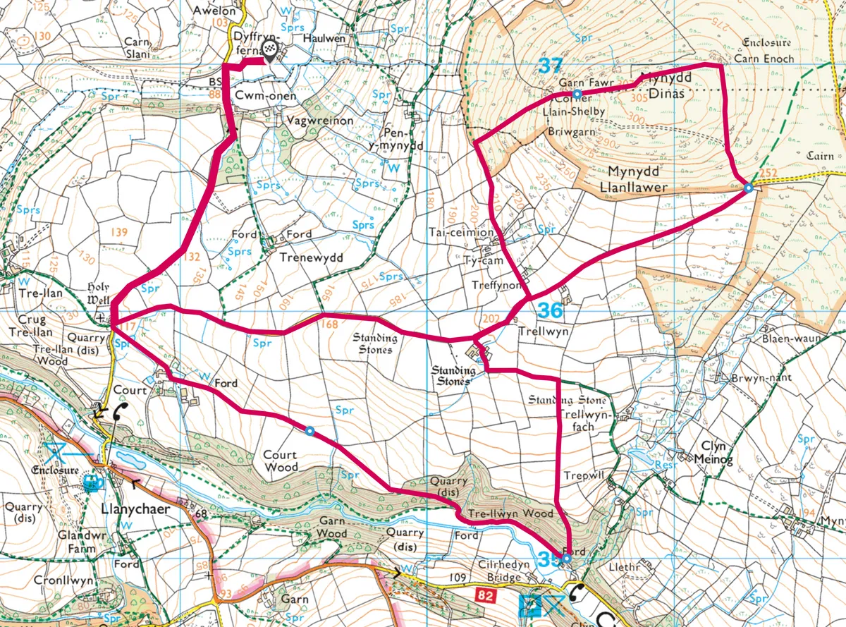
Garn Fawr walk
11.6km/7.2 miles | 4.5 hours | moderate/hard
1. Wishing well
Turn left on to the lane and pass four Scot’s pines – that hint that this may once have been a drovers’ road – to reach the medieval well of Ffynnon Llanllawer. Weeds wave in the dark clear spring (believed to cure eye complaints) rising beneath a stone vault, adorned with flowers in jars. This was said to be a wishing and cursing well in which a straight pin was thrown for a blessing and a bent one for a malediction.

Adjacent is the derelict Victorian chapel of St David’s, built on the site of an earlier church within an oval enclosure, indicating early Celtic Christian origin. Two 9th-11th-century stones incised with crosses are incorporated into the wall at the gate, and two more within the church wall.
2. Spilling waters
Back on the lane, cross the stile-gate and follow the track past a watery grove over the field. You are now in the steep-sided Gwaun Valley, carved by glacial meltwater. Follow the waymarkers past ruined barns and a farm, between steep fields to cross a small ford in a field corner. Bear south-east across the field, passing a standing stone to reach a stile between ash trees.

Trellwyn Wood hides old slate quarries. Ferns and holly grow between the mossy-trunked sessile oaks. Descend the path to the valley base.
The gurgling Gwaun flows fast and clear and bubbling, its mossy bank a perfect picnic spot. Treecreepers spin up the trunks of beech, hazel and willow. Reflections dance on the water over sickles of silver sand. Continue along the river, passing a small waterfall.
3. Moorland rise
Step over a stile before a farm to climb steeply back through the woods, crossing an old rail-track beneath the leaf litter that once carried timber to a saw-mill at Pontfaen.
Arrive in a field and continue along the finch-flocked hedge of ash and blackthorn. Passing the next field boundary, peep through the hedge to see the standing stone of Trellwyn Fach in the next field.
Turn left on to the bridleway between a leafy tunnel of hazel and hawthorn – the passageway guides your eyes to another large stone, Trellwyn Fawr. Pass through the farmyard on to a narrow road and turn right.

With Garn Fawr and Mynydd Dinas above you, continue along the road as it rises, passing scattered rocks into a landscape of tussocky cinnamon moors, with views of the Preseli Hills rolling away to the south-east.
4. Hilltop sculptures
Leave the road at the end of the fence, turning left to climb towards Mynydd Dinas, with the rocks on your right. Continue to Carn Enoch, its stone reminiscent of the sculptures at Dyffryn Fernant. You can now see Dinas Island and the sea.
Make a beeline for craggy Garn Fawr. This is one of the alleged sites of the 1081 battle between Trahaearn ap Caradog, Caradog ap Gruffydd and Meilyr ap Rhiwallon who joined forces to fight and lose against Rhys ap Tewdwr, Gruffydd ap Cynan and the Irish, a disruption that facilitated the Norman invasion of South Wales.

The landscape expands and contracts as you look out to sea and to the Preselis, and then at the intricate garden of lichen on the rock. Around it the grasses whisper.
5. Field of the dead
Head downhill until you reach the boundary separating moorland from farmed pasture. Turn left and follow it between gorse and boulders, crossing a stile, and passing Treffynnon Farm to reach the road. Turn right.
At Parc-y-Meirw – field of the dead – there are two large standing stones used as gate posts, and two more in the hedge. These are the remnants of a Bronze Age stone row, aligned with Trellwyn Fawr and Trellwyn Fach, and probably associated with religious or funerary rites. Some speculate the stones marked a trackway on which the Preseli bluestones were taken to the harbour on their journey to Stonehenge. At the junction, turn right on to the lane, rising and dipping between hedges to return you to the garden at Dyffryn Fernant.
Garn Fawr map
Garn Fawr walking route and map