Horsey’s pale sands and huge skies are evocative at any time of year. But as winter storms roll in and colour leaches from the landscape, this otherwise desolate stretch of the Norfolk coast comes alive with hundreds of breeding grey seals.
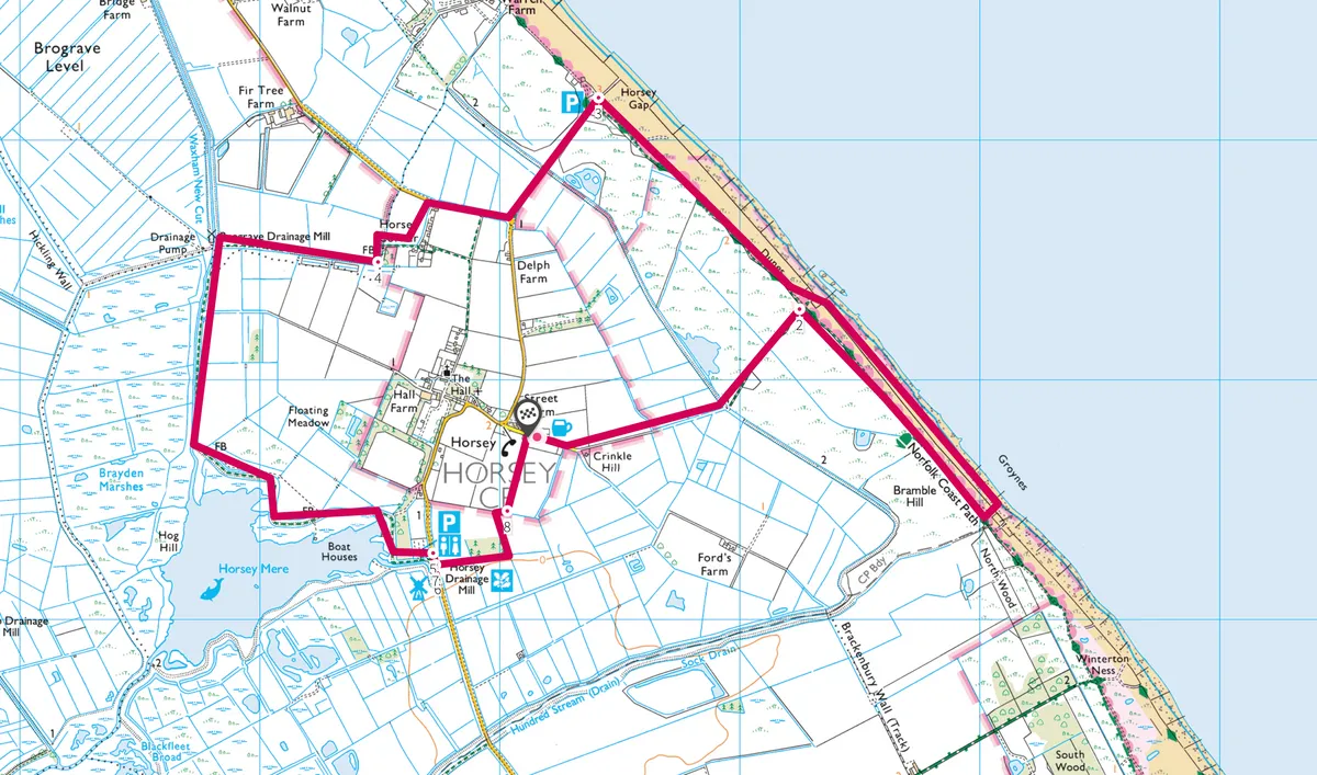
This 6.3-mile loop walk around the village of Horsey in the north-east of the Norfolk Broads National Park, runs alongside the North Sea and then inland through wildlife-rich marshland, before returning to the village pub.
Follow this circular 6.3-mile walking around the village of Horsey in the Norfolk Broads National Park.

Horsey walk
4.8 miles | 3 hours | easy/moderate
1. Nelson head
if you’re intending to use the pub later, start this circular walk at its car park. Otherwise, park at the National Trust car park at Horsey Gap and follow the route starting from point three. Turning left out of the Nelson Head pub car park, follow the track. Bear left at the fork, skirting a gate, and continue on until you reach the dunes. The beach is accessed here through a gap in the sea defences: beyond, you’ll see the seals.

2. Windswept walk
Enjoy a stroll along the beach – giving the seals a wide berth to avoid causing distress – and keep dogs on leads (see friendsofhorseyseals.co.uk for more info). Retrace your steps to the path behind the dunes. As you follow it northwest, watch for marsh harriers above the grazing marshes.

3. Horsey gap
At the National Trust car park, take the exit to the left. Follow the track to the road, turn right for a short distance, then turn left onto a footpath between fields. At the junction of fields, turn right along the field edge. This leads on to a quiet road: turn right then immediately left, following the footpath sign.
4. Herons’ watch
Follow the path, which is here bordered by a dyke where grey herons keep watch. After a little way, a rook-haunted ruined mill appears on the horizon. On reaching the mill, turn left along the edge of the stream. This path, which can be extremely boggy, flanks the National Trust’s Horsey Mere, where wildfowl overwinter in their thousands.

5. Extensive views
The path emerges at Horsey Staithe and the restored Horsey Windpump, built in 1912 and acquired in 1948 by the National Trust. It was once essential to stop flood waters swamping the surrounding fields. Climb to the top for expansive views that confirm Norfolk’s reputation for being pancake-flat.

6. warming fire
Return to the Staithe and the car park, opposite which is a permissive path. Strike out across the field, turning left at the stile, and follow the path back to the Nelson Head, where a welcome warming fire awaits.
Horsey map