Vikings settled in Cumbria in the 9th and 10th centuries, and it is thought that the word Buttermere derived from their descendants led by a Norse chieftain called Buthar, who led a campaign of resistance against the Normans after 1066.
In the Lake District, the influence of these Scandinavians can be heard in the language of the land: streams are becks, ravines are gills, valleys are dales and mountains are fells.
A charismatic line of trees, known as the Buttermere Pines, borders the south side of the lake. They may not have been planted to repel an attack from an invading army, but it seems likely they were grown to protect dwellings at the end of Buttermere from wind.
The pines now draw people armed with cameras rather than clubs and crossbows, making them the most photographed trees in the Lake District.
Henry David Thoreau wrote of tramping eight or 10 miles to “keep an appointment with a beech tree, a yellow birch or an old acquaintance among the pines”. Here in the Lakes, visitors can do the same with a walk of about eight miles, first climbing to the crest of Rannerdale Knotts before returning via the iconic Buttermere Pines.
Discover more great walks in the Lake District, Yorkshire Dales and North York Moors.

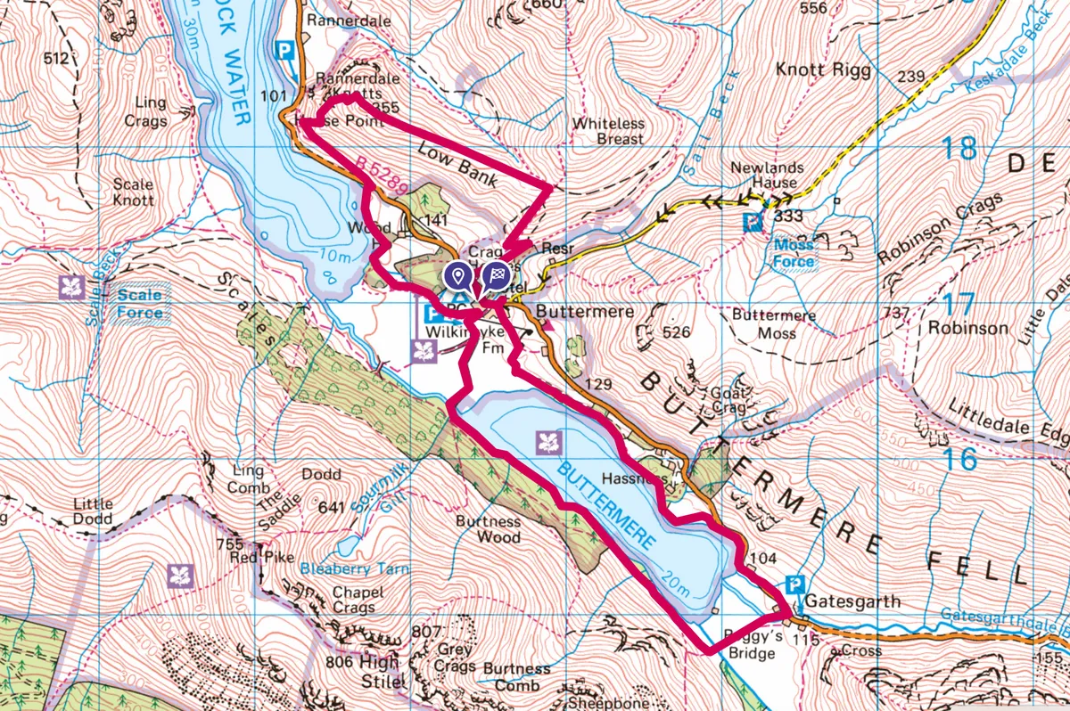
Buttermere and Rannerdale Knotts walk
7.5 miles/12km | 4.5 hours | moderate | 374m ascent
1. Start
From the bottom of the Buttermere village car park, behind The Fish Inn, take the path beside a brook opposite Syke Farm Campsite. Stay with the waterway through a field and, when you reach a small footbridge on your right, turn left and follow another track across the field to Nether How Wood. The path skirts the edge of the trees, soon emerging beside Crummock Water.
More Lake District walks
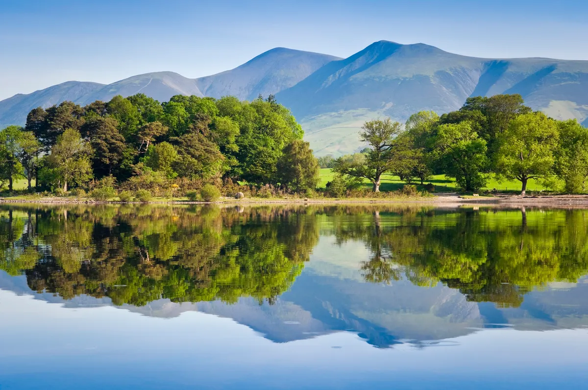
To your right you can see Rannerdale Knotts, and to your left, running almost the entire length of Crummock, is Mellbreak. Like most of the other fells around the lake, this small, isolated hill is formed of Skiddaw slate.

2. Rannerdale Knotts
Follow the lakeshore path to the right of Nether How Wood and up to the road. Cross over to join the bridleway, hugging the side of Rannerdale Knotts. After 500m, take the slightly steeper and more substantial track to the right, ascending to reach a gully. Look for some steps on your right among crags and scree; climb these, then follow the path to the top of Rannerdale Knotts (355m).
On a clear day, you can see beyond Crummock Water to Loweswater, lounging in a valley basin towards the horizon line. There are also great views over Buttermere and the fells beyond.

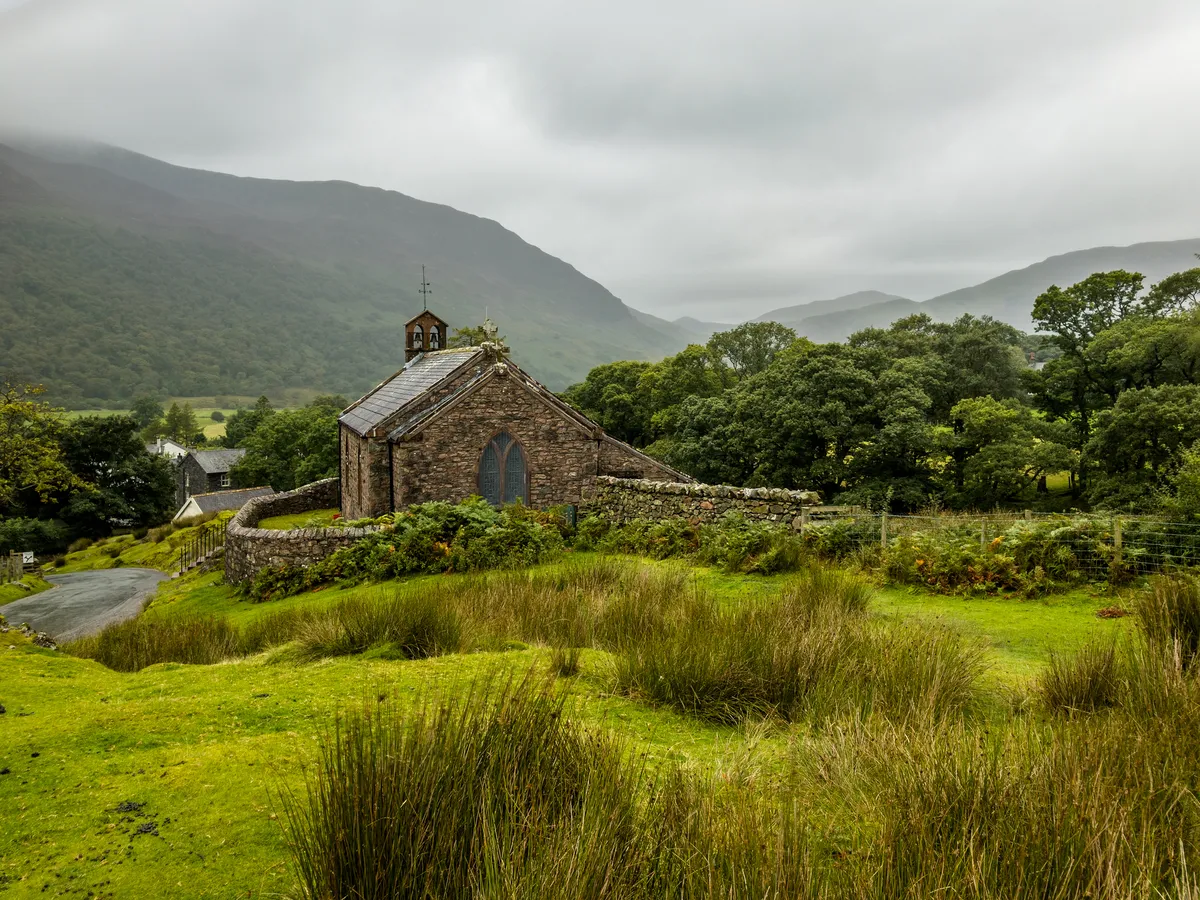
3. Church of St James
Follow the path south-west along the ridge. It is thought that the small valley to the left was used by the Norsemen of Buttermere to ambush the invading Normans.
When the path splits, take the track to the right, dropping downhill until you reach the road. Turn left and follow it for 200m, passing the Bridge Hotel before rising on the main road to visit Church of St James.
Church of St James
The church stands proudly on a small promontory above the road, seemingly enlarging its diminutive stature. It is made of red granite from Sourmilk Gill, which tumbles down the mountainside on the opposite side of the valley. Inside the church, set into a windowsill overlooking Haystacks, is a memorial to Alfred Wainwright, whose ashes were scattered upon that fell.
4. Syke Farm Tea Room
Return down the hill and take the bridleway on the left past Syke Farm Tea Room. While some believe that the name Buttermere evolved from the Buthar legend, others suggest that it simply means the ‘lake by the dairy pastures’. Take a break in the tearoom for a chance to sample the wares of these dairy pastures – their homemade ice cream comes from the cattle that graze here – then pass through the farm and cross a field, taking a bridleway to the right down to the lake shore.
Looking for more of a challenge?
This 25-mile walk explores two of the Lake District's most beautiful valleys – Buttermere and Ennerdale. The hike can be broken into three days, with potential stop-overs on each night at a walkers' youth hostel.

5. Buttermere lake
Once you reach the lake, stick with the main path to enter a thicket of slender oaks. Like the metamorphosed women of Roman mythology, the trees rise from a mossy carpet, writhing after becoming entrapped by the spells of a god, their toes curling around rock and becoming roots, their arms and streaming hair caught in a petrified canopy of twigs and branches as they reach for the sky in an act of suppliance.
The path drops to the edge of the lake, entering a beech, alder and larch woodland, then passes through a tunnel hewn through the rock. The passage was cut for a previous owner of nearby Hassness House who wanted an uninterrupted walk around the lake, and would have provided his workers with something to do in the long winter months.

As the path leaves the trees, ignore a turning to the left and continue to hug the shoreline. Soon you round a headland for superb views of the Buttermere Pines. Behind them, Fleet Pike appears to have risen from the water, dragging itself into being from the depths of the lake. The valley was actually formed 12,000 years ago during the last Ice Age, as glaciers slid towards the Solway Forth.
The ribbon lakes of Crummock and Buttermere surfaced as one long lake but, with time, debris brought down from the fells by becks and gills divided the water in two. The lakes are now home to Arctic charr, one of just a few places in England where these ‘remnants of the Ice Age’ can be found.

6. Buttermere pines
Stick to the lake’s edge, ignoring the main track as it heads across a field, and take the small path on the right to pass beside some birch trees. When this path joins the road, take a right, soon passing the Buttermere Pines. These towering, umbrella-canopied trees are Scots pines, the only species of pine native to the UK. Continue on the road to Gatesgarth Farm, then turn right on to the bridleway.
Follow the bridleway over a bridge, then veer right shortly after, once again hugging the lake. The trail passes a patch of larch known as Horse Close. Up to the left, Comb Beck plummets as a series of waterfalls from the immense buttresses of High Crag and High Stile.
7. Buttermere village
Stay on the track closest to the lake, soon entering mixed-pine woodland. After about a mile, take a right across a stone bridge and follow the track across a field. The path veers to the left, leaving the lake behind on a well-graded trail back to the village and the car park.
Buttermere walking map
Buttermere walking route and map