The Yorkshire Dales was designated as a national park in 1954 and today receives more than three million day visitors every year. There are 2,628km of footpaths and 618km of bridleways, offering visitors the chance to spot the park's 1,000 species of moths, its 100 species of nesting birds, and more than 30 species of mammals.
The Yorkshire Dales may be land-bound, but what it lacks in coastal drama it makes up for in magnificent moorlands, deep valleys and striking limestone crags, from the villages and towns of Settle and Hawes to the wild landscapes of Malham Cove and Malham Tarn.
Here, we take a look at some of the very best walks in the Yorkshire Dales – from circular lake walks and short waterfall walks, to hikes with pubs and great hill walks. Each route has a OS Map and walk description.
Looking for more walks in Britain's national parks? Check out our favourite routes in the Peak District, Lake District and North York Moors.
- Cottages in the Yorkshire Dales: five beautiful places to stay
- Camping in the Yorkshire Dales: five magical campsites
- Hotels in the Yorkshire Dales: five heavenly stays
Learn more about Britain's national parks
What is a national park, how many national parks are there in the UK, and where is the nearest one to you? Our guide to the UK's 15 spectacular national parks looks at the history of each, how to visit them, the best walking routes, and local wildlife to spot.

Yorkshire Dales walks
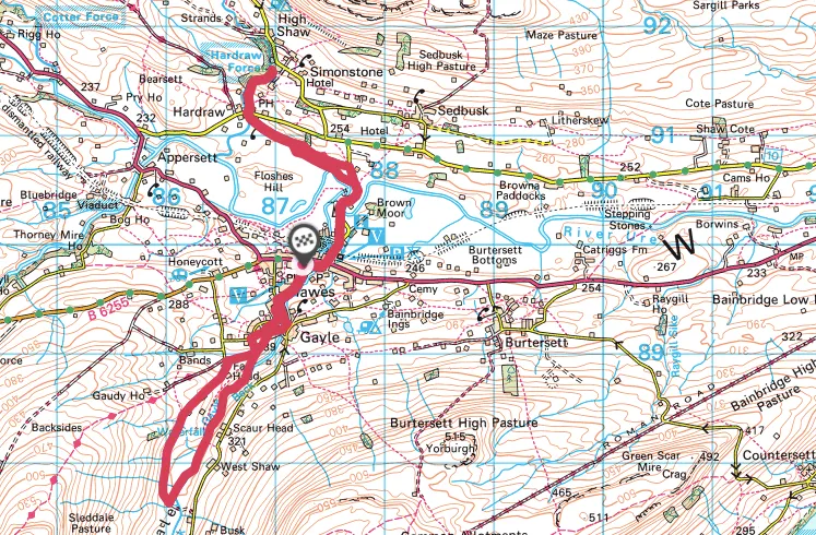
Hawes, Aysgill Force and Hardraw Force
7 miles/11.3km | 5 hours | moderate

Long before there was Yorkshire, there was ice. For millennia, thick, endless sheets of it covered the area – now the Pennines – while active glacial tongues scoured away ancient river courses, remodelling the geomorphology of the land surface.
Wensleydale was at the heart of this chaos and today’s River Ure flows in an over-deepened, over-widened vale. Its myriad higher tributaries cut down through the geology to achieve parity with the main valley, redefined as the last glacier melted some 12,000 years ago.
Visit a series of enchanting waterfalls on this 7-mile walk, starting and ending in the Yorkshire Dales village of Hawes.
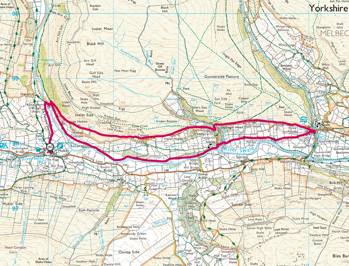
Muker
6.8 miles/11km | 4 hours |moderate

Muker's landscape is largely unchanged from the late-18th and early 19th century, and those iconic features of the Dales – the field barns and the drystone walls – radiate from the village.
Muker is also famous for its species-rich hay meadows. In late spring, these meadows burst into life – a colour bonanza best absorbed after a cup of Yorkshire tea and a slice of cake. This splendid 7-mile circular route starts at Muker and follows the River Swale east to the village of Gunnerside.
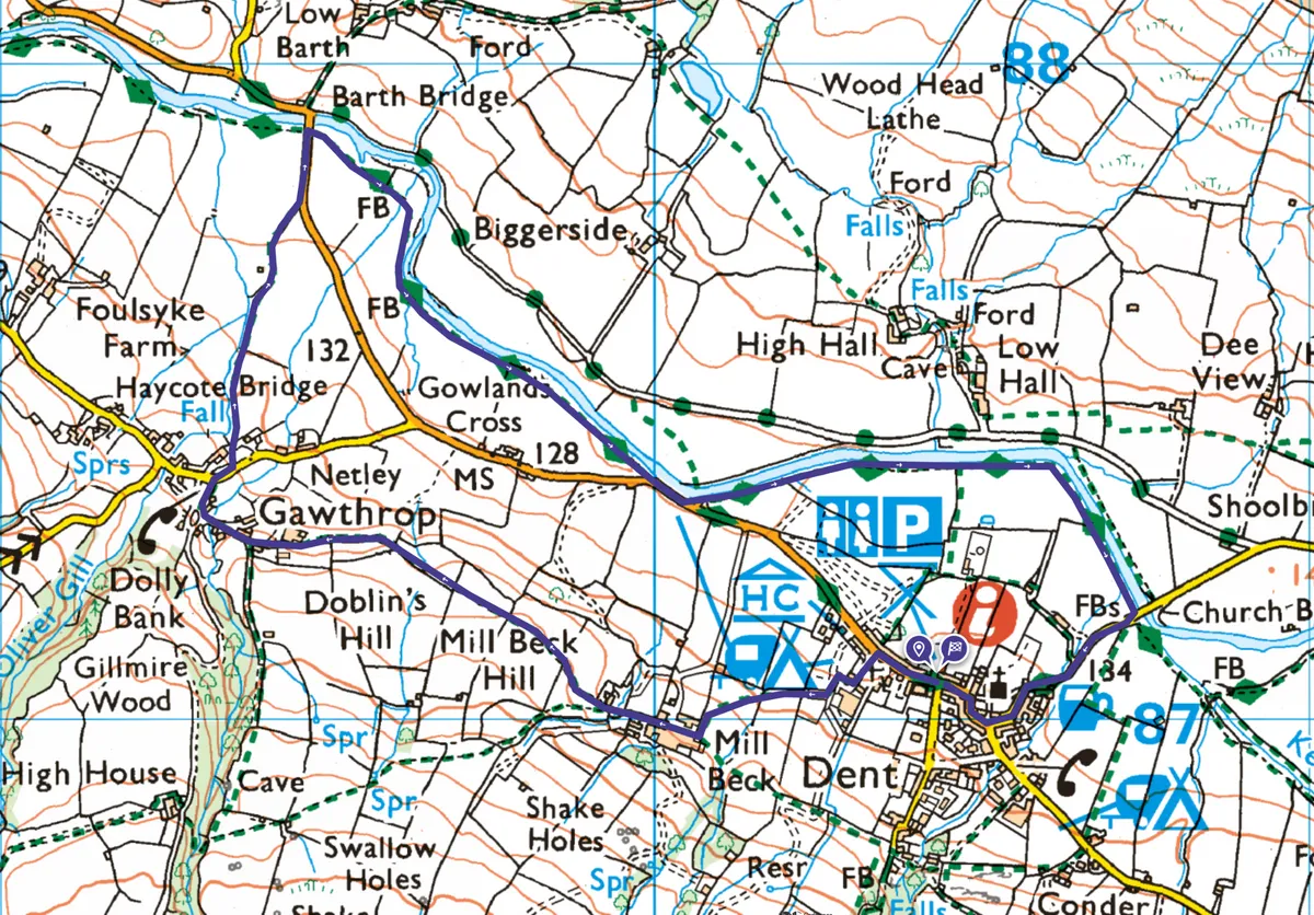
Dentdale
2.5 miles/4km | 1.5 hours | easy

The Yorkshire Dales contains most of Britain’s surviving upland hay meadows, traditionally farmed to allow wildlife to thrive. Dentdale is one of these valleys, divided into a patchwork of idyllic stone-walled fields colourfully blanketed in wildflowers in spring and summer.
Starting from the narrow, cobbled streets of Dent, take time on this walk to look down on species such as meadow buttercup, eyebright and red clover, but also to gaze up at the lofty hills, rising to the highest points in both Yorkshire and Lancashire.
Malham Tarn
3.6 miles/5.8km | 2 hours |easy-moderate

This short walk around Malham Tarn, beneath the looming cliffs of Great Close Scar, offers ramblers a chance to experience a variety of habitats, from craggy limestone bluffs, to thick forest, dark peatland and a wildlife-rich upland lake.
At 377 metres above sea level, Malham Tarn is the highest marl (calcium carbonate or lime-rich mud) lake in Britain.
Keep an eye out for wild creatures as you go, including waders and ducks.

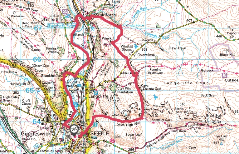
Settle to Stainforth
8.5 miles/13.7km | 5 hours |moderate

Settle Up’ and ‘Settle Down’ proclaim the platform benches as you step off the train at Settle’s lovingly restored station, gateway to the pretty little market town and a landscape rich in gleaming limestone scars, caves and potholes.
This 8.5-mile circular walking route starts in Settle, venturing beneath Attermire Scar and beyond Catrigg Force to Stainforth, before returning to Settle via Stainforth Force.
Discover more national park walks
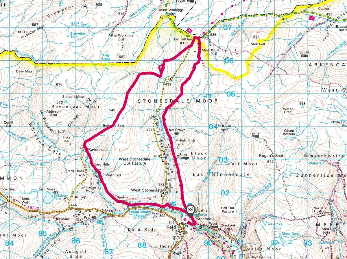
Keld to Tan Hill Inn
10.2 miles/16.5km | 6 hours |moderate

On a lonely site high in the Yorkshire Dales stands a unique and historic place. With its exposed beams, stone-flagged floor and welcoming fire, the Tan Hill Inn, Britain’s highest public house at 528m (1,732ft), is a place where walkers brush shoulders with inquisitive tourists.
This walk takes you from Keld to the head of Arkengarthdale on the edge of Swaledale, where winds rush across moorland, and where you can stop at the warm pub to refuel or rest your weary head.
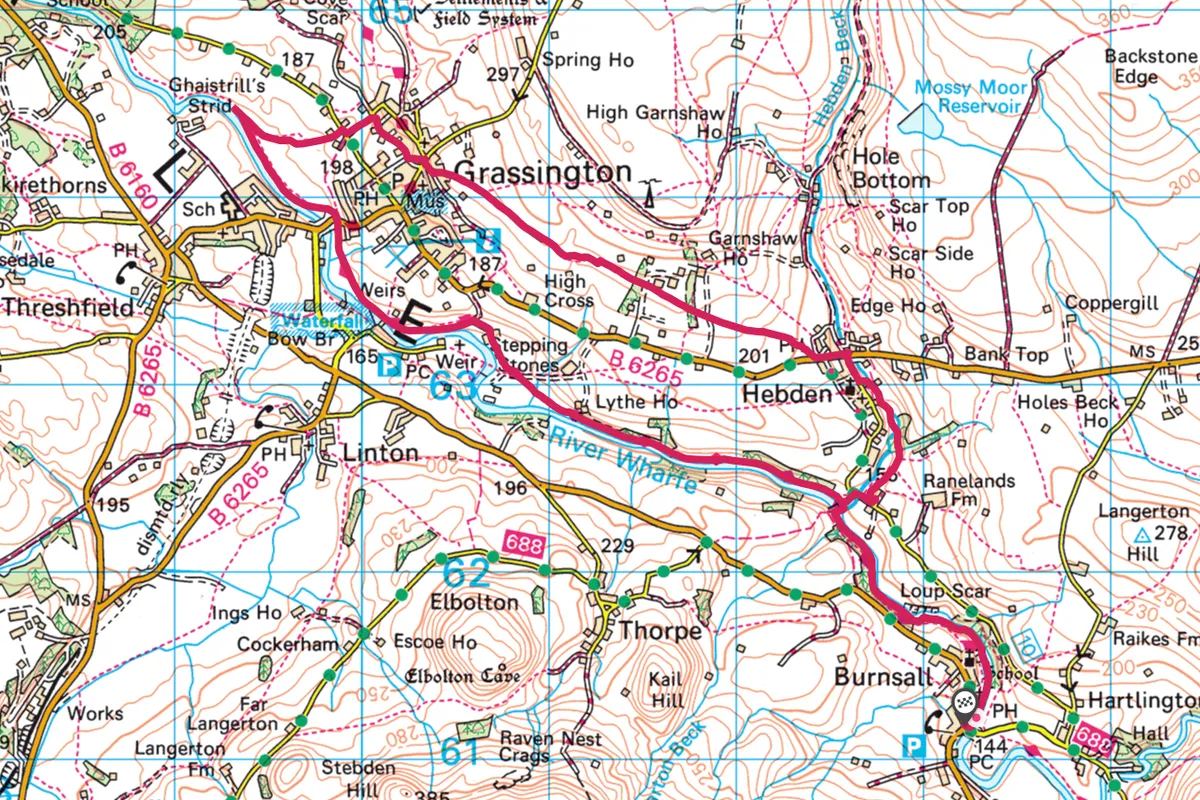
Grassington
8 miles/12.8km | 4.5 hours | moderate

The countryside around the Yorkshire Dales village of Grassington is dotted with pools and falls, making it an idyllic location for a spot of wild swimming. In the meadows south of Grassington, families mess about in rubber dinghies, skip over stepping-stones and throw themselves down water chutes.
Nearby Ghaistrill’s Strid offers exhilarating rapids, while Loup Scar tempts the more intrepid with a high jump and plunge pool. Enjoy all of the above on this riverside ramble along the banks of the Wharfe.
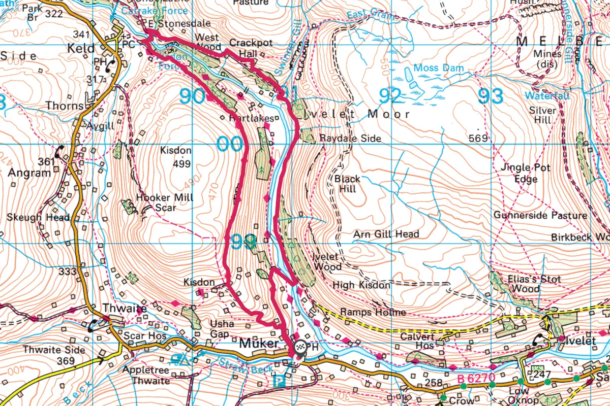
Crackpot Hall and Upper Swaledale
6 miles/9.6km | 3.5 hours | moderate

Yearning for wide open spaces? This wonderful high-level walk meanders past a storied ruin and ends at an attractive waterfall in a little-visited, yet glorious pocket of the Yorkshire Dales.
The walk starts in the little village of Muker in the heart of Swaledale, a lush green valley with a patchwork of tiny fields and barns. This has never been one of the more popular tourist dales, but our walk takes in the area at its best and most dramatic.
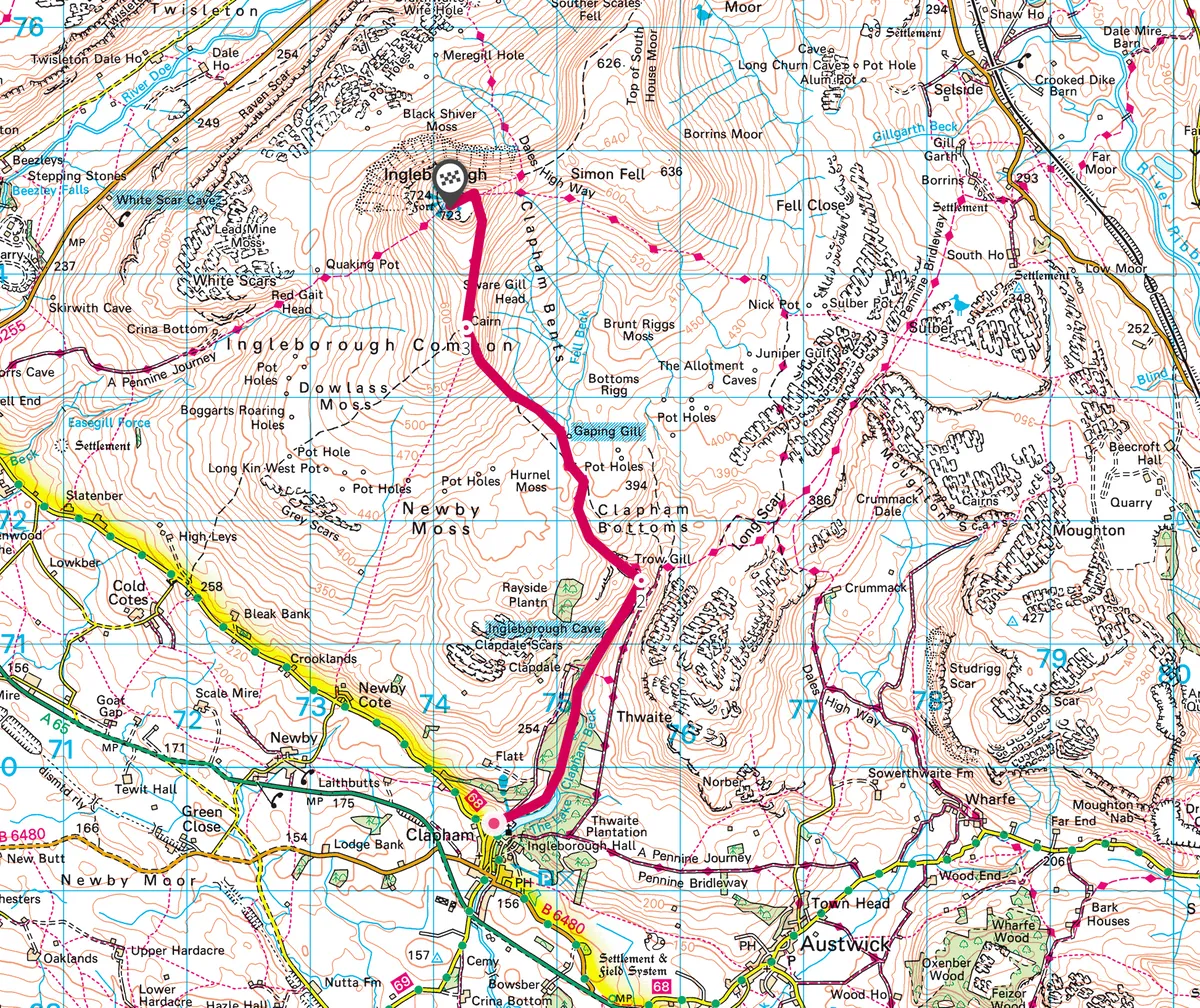
Ingleborough
4 miles/6.4km | 2.5 hours | moderate

Walk the second highest peak in the Yorkshire Dales, a mountain pockmarked with cavernous sinkholes, rumbling rivers and labyrinthine limestone paving. This 8-mile route to the summit and back takes you to a mysterious chasm and a famous pothole.
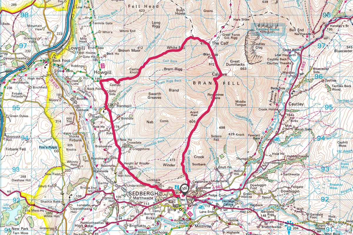
Howgill Fells
9.6 miles/15.5km | 5–7 hours | challenging

Don’t let its proximity to the M6 fool you into thinking that this is a well-used tourist circuit. Once you leave behind the ancient market town of Sedbergh and climb to reach the heights of Brant Fell, at more than 190m (600ft) above sea level, you will find yourself in a stunning but isolated landscape that’s well and truly off the beaten track.
The route starts from the centre of Sedbergh, a delightful market town that is situated at the confluence of four valleys and four rivers, and where ancient trading routes met. Over the centuries the town’s main industries have been based largely around sheep farming and the manufacture of woven and hand knitted products.
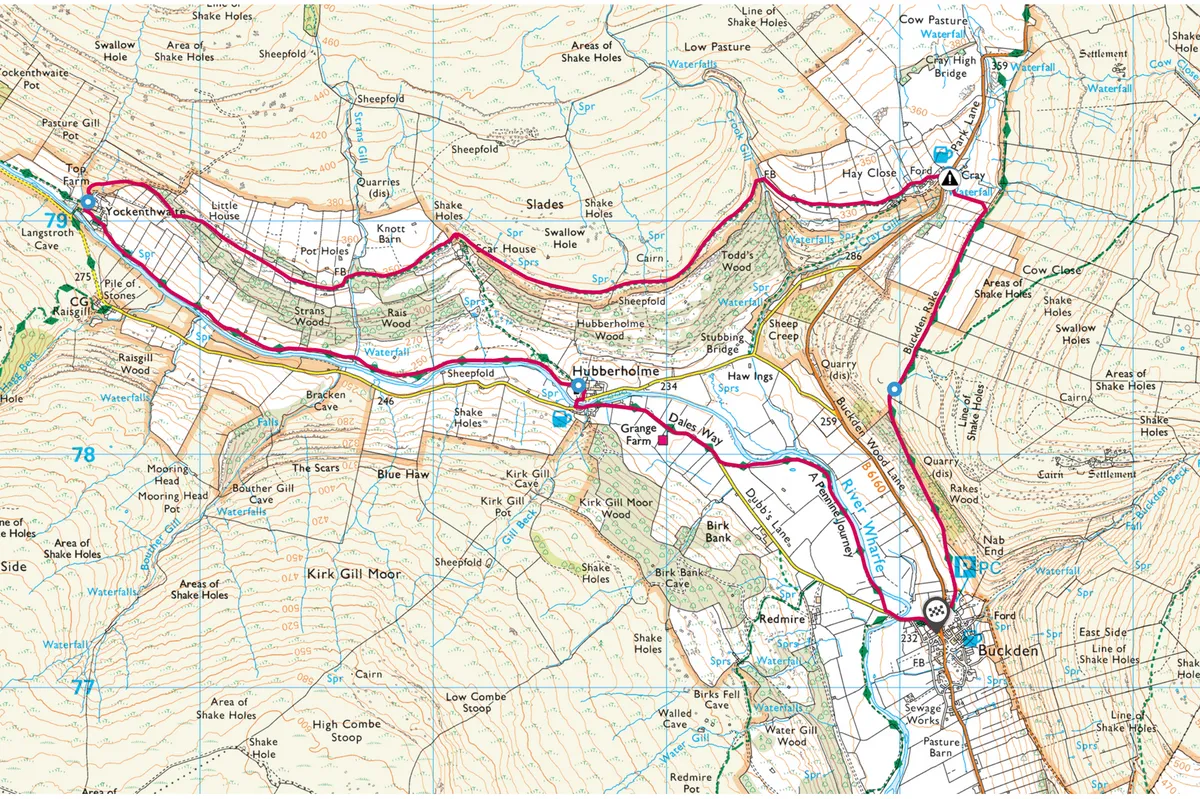
Upper Wharfedale
6.9 miles/11.2km | 4 hours | moderate

Upper Wharfedale is a charming little valley off the beaten track where the roads are too narrow for trucks and busses to navigate. It’s a bit of a bind to get to, but once you’ve found the dale, you’ll never forget it.
The limestone and peat uplands hereabouts are riven with steep-sided valleys and ghylls where water teems off the fells and tumbles over a series of waterfalls through the heart of the picturesque villages of Cray, Yockenthwaite and Hubberholme.
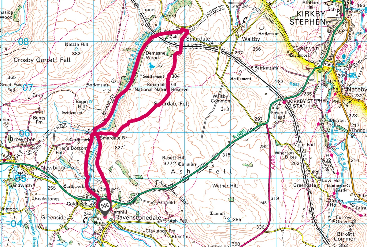
Smardale Beck
7 miles/11.3km | 4 hours | moderate

An old viaduct, built in 1861, rises almost 30m on 14 stone arches above Smardale Beck – it’s a fine vantage point for spotting all-year-round residents to the national nature reserve, such as sparrowhawks, buzzards and treecreepers. Enjoy a spectacular 7-mile walk through a secluded gorge in the Yorkshire Dales National Park.