Whispering trees, roaring streams, lush undergrowth and panoramic views; Sugar Loaf mountain – or Mynydd Pen-y-fâl in Welsh – offers all of these, yet is often overlooked in favour of loftier Pen y Fan and Cribyn to the west.
Swap a little altitude for a lot of peace and quiet by heading to this perfectly formed peak, tucked away on the eastern outskirts of the Brecon Beacons National Park, where you get maximum reward for a short but satisfying climb. It’s also a great day out for families.
Rising above Abergavenny, the pinched peak is accessed by soft slopes on all sides, making for a solid and consistent workout whichever angle you approach from.
Here, we offer two of the best routes to the summit of Sugar Loaf, the first negotiating the south-west slopes of the hill, and the second climbing the south-east slopes.
Those who fancy a longer day you could ascend the peak directly from Abergavenny.

Sugar Loaf walk: south-west route
5.2 miles/8.4km | 1104 feet/336m ascent | 3 hours | moderate
1. Car park
Beginning at the scenically placed car park on the peak’s southern slopes, follow the grassy path north-west.
2. Woodland
Continue over a crossroad of paths, ignoring any tracks that break off to the right. After a mile, drop down into woodland. Cross the stream before contouring round the peak to a path that leads directly up its western side.
3. Sugar Loaf summit
Climbing eastwards, you’ll soon reach the trig point at summit of Sugar Loaf. The moderately stiff ascent rewards with panoramic views of Wales’ Black Mountains.
4. Walk south
Leave the summit via the south-westerly path, which will bend round to south-south-east, running parallel with your ascent route within a couple of miles.
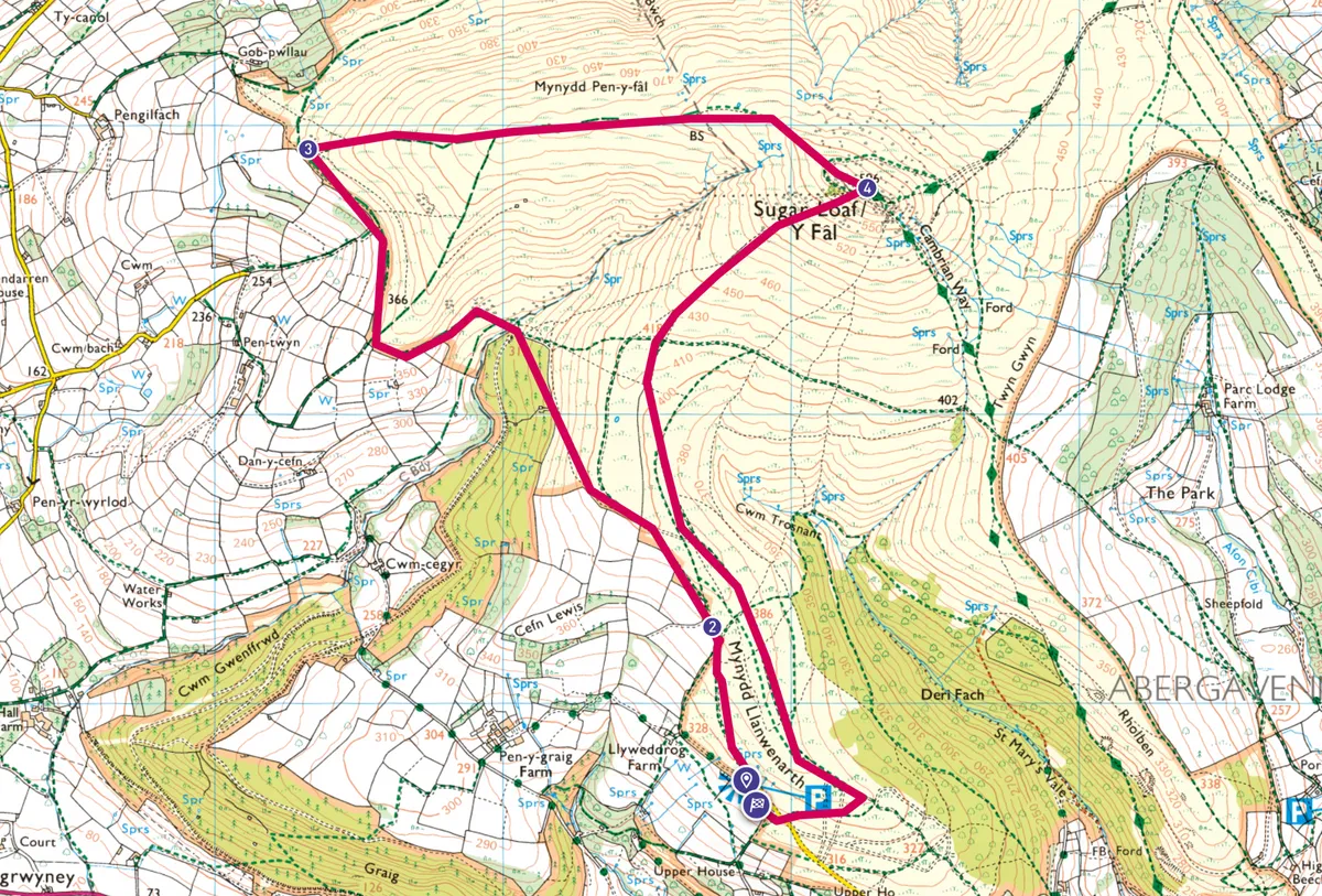
Sugar Loaf map: south-west route
Sugar Loaf walking route and map
Sugar Loaf walk: south-east route
4.5 miles/7.2km | 1466 feet/447m ascent | 3 hours | moderate
1 Car park
Turn left out of the parking area, then immediately fork right up a dirt road. At the bend, branch left to pass through a gate and enter a forest of mature trees. If you’re lucky, you’ll have it all to yourself, and the only sound you’ll hear is birdsong and the babbling of a brook below the track.
Keep heading north-northwest for just over half a mile. As the trees recede you’ll see the Black Mountains rolling away into the distance, with a few small villages nestling in the quiet countryside.
2 North-bound path
At a fork 200m beyond the wood’s edge, branch right and continue in the same direction. When the ground plateaus at the 405m contour line, you’ll spy Sugar Loaf’s distinctive triangular peak.
As the path winds north, join a wide track and maintain the northerly course until you’re level with the summit, on its right. Suddenly the path becomes steeper and rockier as it curves northwest, round the back of the summit, then due west and southeast to the summit cairn.
3 Sugar Loaf summit
Sugar Loaf’s 596m (1,955ft) summit is long, flat and narrow, like the top of a loaf of bread. Pen Cerrig-calch dominates the view to the west and, if the day is clear, you may see all the way south-east to the River Severn and east to the Forest of Dean, while to the west the central Brecon Beacons, including Pen y Fan and Cribyn, are visible.
To head down, take the track running south from the summit.
4 Spring break
Continue in this direction until the views become blocked by small heathery rises to either side and a spring emerges to the left. Soon you meet a stream, where several paths meet. Take the track that bears left along the opposite side of the river, then almost immediately branch right uphill, away from the bank and past some mature trees.
5 Return to the trees
The path levels out and enters the wood. Keep going southeast until you meet another path perpendicular to the track you’re on. Turn left, then left again at the next fork, and continue downhill to the fence. Turn left on to a dirt path that follows the fence and, just past the shed on the right, turn left on to a much wider path. When the path forks, take the right-hand branch to the edge of a picturesque, tree-lined river.
Carefully follow the river downstream and after 200m cross a narrow bridge. Continue along the far bank and through a gate to find the car-parking area on your right.
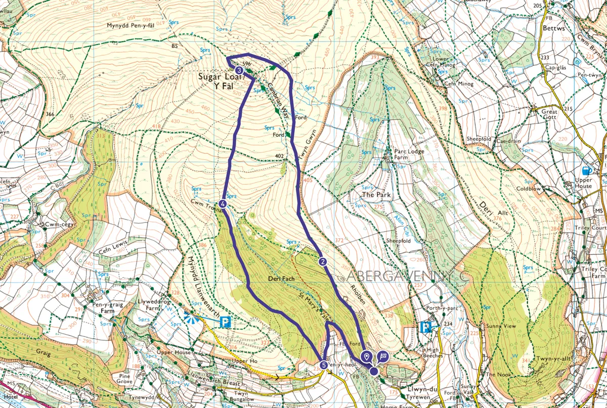
Sugar loaf mountain map: south-east route
Sugar Loaf mountain walking route and map
Useful information about Sugar Loaf
How to get there
Abergavenny is on the A40, about 15 miles north of Newport. To reach the start of the walk, if approaching from the south follow the A40 through the town centre, then turn right on to Chapel Road, which eventually becomes Pentre Road. Just past a long cream-coloured cottage, turn left on to a narrow lane and continue until you reach a small parking area on the left. Regular trains and hourly Stagecoach bus X3 run from Cardiff to Abergavenny Station, about two miles from the start of the walk.
Find out more
Abergavenny Tourist Information Centre
Tithe Barn, Monk Street, Abergavenny NP7 5ND 01873 853254
Refreshments
Two locals with hearty pub food and ales.
The Hen and Chickens
Flannel Street, Abergavenny NP7 5EG 01873 853613
Lamb and Flag
Brecon Road, Llanwenarth, Abergavenny NP7 7EW 01873 857611
Nearby
Abergavenny Museum
Local museum set amid the ruins of a Norman castle.
The Castle, Castle Street, Abergavenny, NP7 5EE 01873 854282
Map
OS Explorer OL13
Grid ref: SO 28337 16253
Words by Dan Aspel and Nicki Giles

