In a bid to tackle the climate and biodiversity crisis, scientists using innovative high-tech aerial laser-scanning technology have created the first accurate maps of England’s hedgerow network. Researchers at the UK Centre for Ecology & Hydrology (UKCEH) hope their mapping will be a tool to guide planting and restoration of these crucial wildlife habitats.
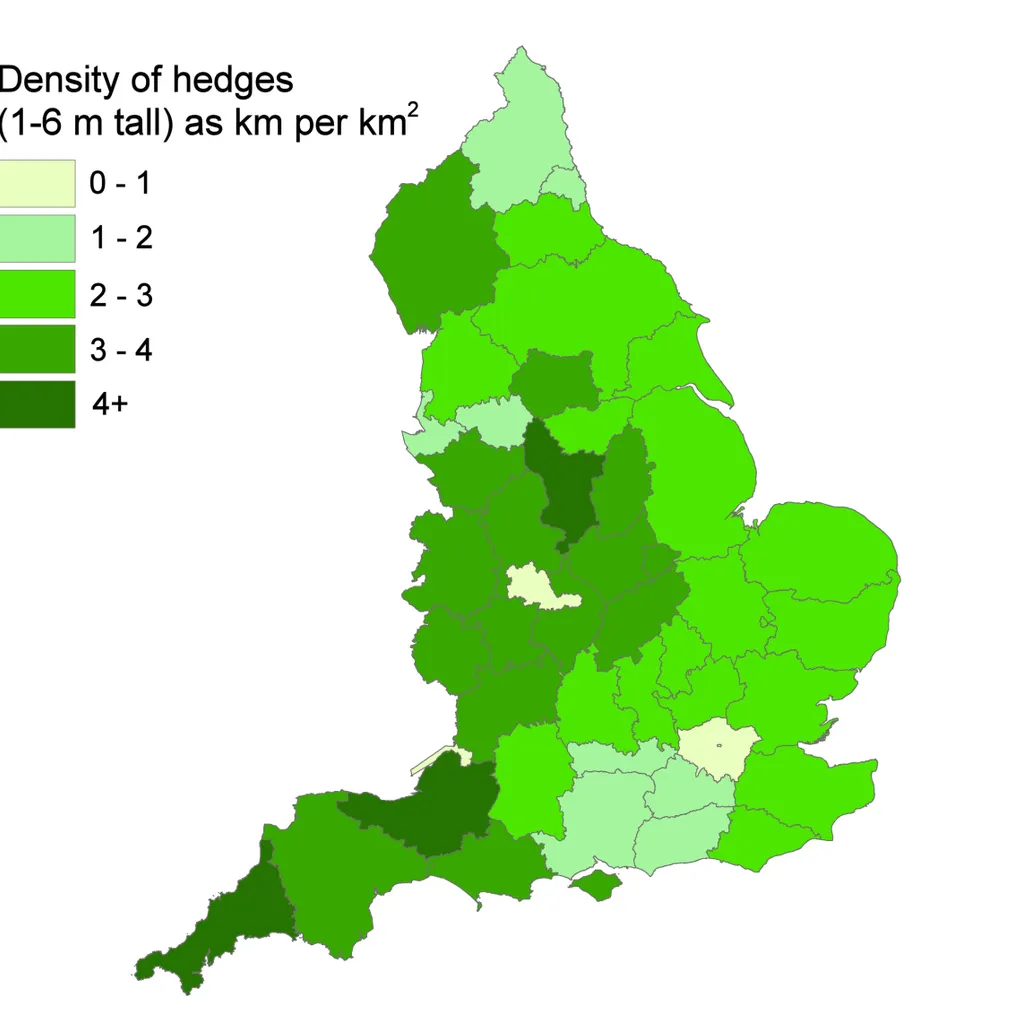
The maps reveal a total of 390,000km (242,300 miles) of these historic field boundaries (that are between and six metres in height) – enough to wrap around the world almost 10 times.
While hedgerows are integral to the British rural landscape, marking field boundaries and keeping in livestock since the Bronze Age, post-war government policies put them at risk. It’s estimated that approximately half of Britain’s hedgerows – mostly in England – were lost to development and the rapid industrialisation of farming between the 1950s and 1990s. And in more recent years, a lack of maintenance is resulting in gappy hedges.
Lead researcher of the UKCEH hedgerow map project, Dr Richard Broughton, says: “Hedgerows are not only an intrinsic part of England’s rural heritage, they can also be a real asset in helping to tackle the biodiversity and climate crises.”
Hedgerows contain a wide variety of trees, shrubs and flowers that provide food, shelter, nesting and burrowing sites for birds, small mammals and insects. The dense foliage of a hedge offers a safe haven, protecting birds from raptors, foxes and cats, and their linear vegetation acts as a wildlife corridor, linking habitats across farmland.
Hedgerows are also a valuable resource for carbon capture. Dr Broughton adds: “The new map enables us to see where hedgerows are sparse and identify sites for targeted planting and restoration efforts, linking up habitats and improving the hedgerow network. It can also be used to estimate the potential amount of carbon that hedgerows could remove from the atmosphere and store.”
- How to identify common hedgerow species
- Podcast: Take a hedgerow safari with TV naturalist Dr George McGavin
- The role of the British hedgerow
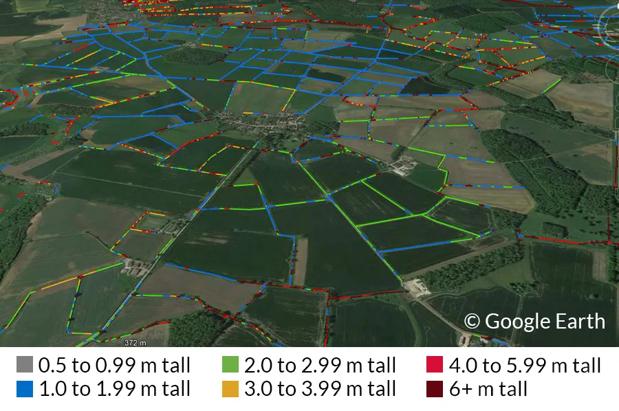
The highest hedgerow densities are found in Cornwall, with an average of 5.1km per 1km x 1km square, while the lowest densities are found in Surrey (1.2km per square kilometre), Hampshire (1.5km) and Berkshire (1.7km). UKCEH also mapped another 67,000km of rows of vegetation below 1m in height, and 185,000m taller than 6m, including overgrown hedges that have become rows of young trees.
The UKCEH’s hedgerow maps were made possible by the release of the Environment Agency’s LiDAR (Light Detection and Ranging) remote sensing data, which was collected over five years as part of the agency’s mapping work. UKCEH scientists then processed the huge amount of data using the JASMIN super-computer – a data analysis facility that enables data-intensive environmental science.
"The LiDAR (aerial laser scanning from an aeroplane) measures the height of everything on the surface of the landscape, in every square metre – houses, woods, and hedges," says Broughton. This is how the team had enough detail to identify and measure all of the hedgerows directly, rather than using small samples and trying to estimate the rest. “This has been long-awaited progress, because people really care about hedgerows, but until recently the monitoring, planning and research has been limited by now knowing quite how many we had, or quite where they were.”
"We hope that people will use and develop the map in creative ways to suit their uses."
Dr Richard Broughton, UKCEH
Broughton says the hedgerow data is now available to anyone who would like to use it, from academics to farming and conservation organisations. “We hope that people will use and develop the map in creative ways to suit their uses.”
To measure the amount of carbon a hedgerow could remove from the atmosphere would involve some complex mathematics and lots of measuring in the field to calculate how much carbon is captured and stored by hedges of different sizes and types, explains Broughton. By using the national map, the sampling could then be extrapolated to scale up the results and find estimates for larger areas, or the whole woody network. “There is lots of research happening in this rapidly developing topic, and so the science is moving very quickly, with exciting developments all the time," adds Broughton.
An episode of the UKCEH’s podcast Counting the Earth takes a deeper look at the ecological importance of hedgerows, and includes interviews with hedge-layer Alex Musson and Devon farmer Robert Wolton, who spent two years recording the species he found in one hedge close to his home. Wolton found 2,070 different species, including mosses, birds and insects, 12 shrubs, and 60 nationally scarce species, including willow tits and hazel dormice.
In January 2023, the Government pledged to support farmers to create or restore 30,000 miles of hedgerows a year by 2037 and 45,000 miles a year by 2050, as part of its Environmental Improvement Plan.