Cocooned between Pembrokeshire’s rugged coastal cliffs, Lower Fishguard can trace its herring industry back to the 16th century. During Elizabeth I’s reign, enough herrings were landed here to feed her entire army. Even the locals were called ‘sgadan Abergwaun’ (which translates in English to ‘Fishguard herrings’).
Near the car park, a bronze sculpture of a shoal of herrings celebrates the catch that was once the backbone of this harbour’s economy.
Quaint cottages line the quayside where herring stores once stood. In 1971, it was the perfect set for a film of Dylan Thomas’s Under Milk Wood, starring Richard Burton, Elizabeth Taylor and Peter O’Toole. One such building, the Fishguard Yacht Club café, offers mouthwatering diversions, including locally caught fresh fish, shellfish and local ice cream.

The bench-lined quayside is a crabbing paradise and those patient enough with a rod might catch a pollack, wrasse, dogfish or mackerel. At low tide, curlew, redshank and sanderling forage within the harbour walls.
The harbourmouth viewpoint offers sightings of the Irish ferries at Goodwick and occasional grey seals, porpoises and dolphins, too. And as the Sun Lover sculpture shows, it’s the perfect place for catching a few rays from this west-facing suntrap.
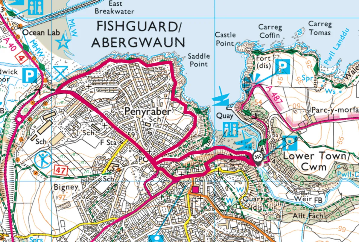
Lower Fishguard walk
2.4 miles/3.8km | 2 hours | easy–moderate
1. Stone Circle
For more charming views and coastal delights, leave Fishguard Lower Town car park (free), head to the road bridge, turn right across the river (no footpath), then turn immediately right into another car park. Bear left on to a tarmac quayside path to some 19th-century lime kiln remains. Climb this narrow lane to the main road.
Double-back along Penslade to the Gorsedd Stone Circle – which commemorates the National Eisteddfod’s 1936 visit – and drink in beguiling views over Lower Fishguard. At the end of the road, continue on the tarmac path.

2. Port protector
Opposite, perched on a narrow headland projecting into the Irish Sea, stands Fishguard Fort. Locals built it in 1779 after a privateer captured a local ship, held it to ransom and, when the locals wouldn’t pay up, bombarded the town with cannonballs.
Join the coast path and turn left for far-reaching views stretching from Dinas Head round to Goodwick.

3. Surrender Sands
In February 1797, 1,200 French troops surrendered at Goodwick Sands, following a failed three-day invasion. This is the last time foreign troops invaded mainland Britain.
At the main road, turn left and walk for half a mile, passing Penslade again (on the left) to reach a roundabout junction.
4. Invasion tapestry
The Royal Oak pub on the left is where English and French generals signed the Last Invasion Peace Treaty. In the Town Hall opposite, the 100-foot-long Last Invasion tapestry tells the story through needle and thread.
To return to Lower Fishguard and the car park, follow the main road through town, dropping steeply to the harbour.
Lower Fishguard map
Lower Fishguard walking route and map