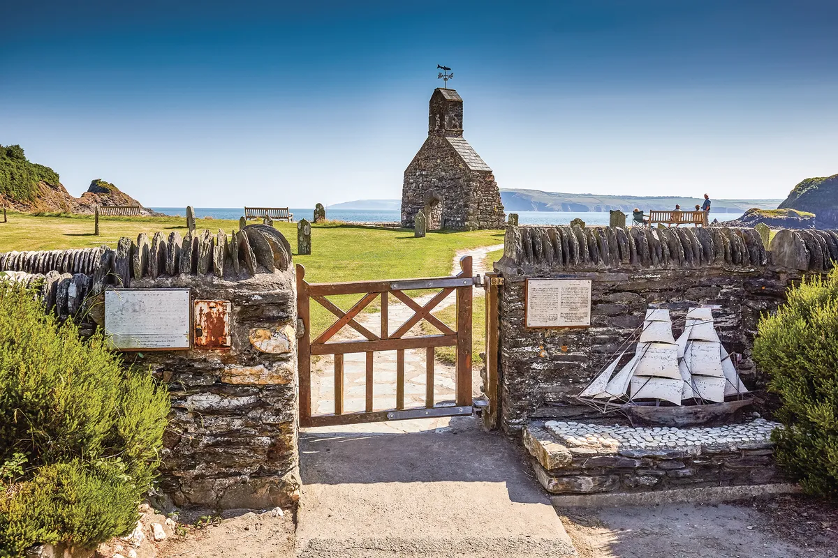
You know you’re going somewhere special when the road is so narrow the yellow lines on either side practically touch each other. It all adds to the magic of the descent into the cosy, cocooning north-east-facing cove of Cwm-yr-Eglwys (Valley of the Church).
Here, quaint cottages huddle together in a narrow valley, sandwiched between Pembrokeshire’s dramatic, rugged coastal cliffs. This valley is all that links Dinas Head – often labelled on maps as Dinas Island – to West Wales, giving it an island-like feel without the need to cross water.
Things to see and do at Dinas Head
Pembrokeshire’s coastal path circumnavigates Dinas Island, offering fantastic views across huge swathes of Cardigan Bay. Peer carefully on a clear day for a glimpse of the Llŷn Peninsula. Listen out for the screeches and chattering of nesting razorbills, guillemots and fulmars on Needle Rock, a jagged outcrop a few metres off the headland.
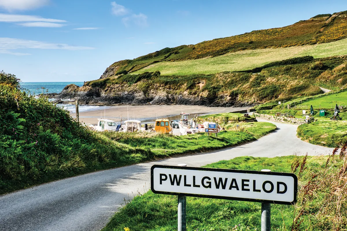
Pause and catch your breath at the 142-metre summit of Pen-y-Fan, with its 360° views, before descending to west-facing Pwllgwaelod. Popular with boaters and protected from northerly winds, this cove is also home to the Old Sailor’s Tearoom and Restaurant, once frequented by Dylan Thomas.
The amble back to Cwm-yr-Eglwys is along a flat, wheelchair and pushchair-friendly path, which means connecting these cosy coves can either be an energetic three-mile circular walk, or a soothing two-mile linear stroll.
You may also like
Dinas Head walk
2.9 miles/4/7km | 2 hours | moderate
1. Church Valley
From Cwm-yr-Eglwys’ small car park (with toilets), explore the beach and the ruins of St Brynach. Look out for the model of the Cwm Trader, a flat-bottomed vessel, popular at the time of the Royal Charter storm. These boats were ideal for sailing into small coves such as Cwm-yr-Eglwys at high tide, for unloading by horse and cart at low tide.
Take the narrow lane, signed as a private road and footpath, which meanders and climbs between several cottages. At the end of the lane (a private driveway), turn right on to the signed Pembrokeshire Coast Path, between fences and around a garden, to reclaim the coastal edge. A series of steps opens up great views along the coast towards Newport.
The path bears left, climbing more steps while meandering between high hedges, to reach the entrance to Pen Dinas (National Trust). Pass through a gate to reach a junction of paths. Although either route can be taken, for the best views of Needle Rock take the right fork.
Listen out for the cracking of gorse pods as the June sunshine heats them until they explode, spreading their seeds far and wide. Marvel at the squadrons of speckled wood and red admiral butterflies sunning themselves on the path.
2. Needle Rock
Needle Rock is about halfway between Cwm-yr-Eglwys and Dinas Head summit. Take care here, for the drop is steep and dangerous. Between May and July, this sharp, rocky outcrop becomes a frantic nesting ground for razorbills, guillemots, fulmars and shags, because it’s safe from many natural predators. Check the surrounding waters for seals, dolphins and porpoises, frequently spotted around this rugged sea stack and much of Dinas Head.
The path continues climbing steadily up a series of steps, eventually reaching a gate, perfect for pausing for breath and gazing out along the coastline of Cardigan Bay.
The path narrows, especially at this time of year when the bracken spreads, and eventually reaches a kissing gate. Continue through, then rejoin the field-side path you left earlier.
Turn right, continuing to climb, passing through another kissing gate alongside a field on the left. Finally, fork right to reach the trig point – the highest point of Dinas Head at 142 metres (465 feet).
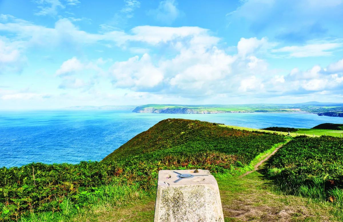
3. Summit sights
Looking north from the summit trig point offers views encompassing most of Cardigan Bay, and the Llŷn Peninsula on a clear day. Inland, to the east, are Pembrokeshire’s Preseli Hills, and to the south-west the coastline stretches to Fishguard and beyond.
Just around the headland beyond Goodwick Harbour lies Carregwastad Point. It was here, in 1797, where French troops landed in what was to become the last invasion of mainland Britain.
Continue along the path in an anti-clockwise direction around Dinas Head, descending with a field on the left and the sea on the right. At a field corner, the path bears round to the left and soon after bears right, dropping to a gate. Go through the gate and continue dropping along the gorse- and heather-lined narrow path.
4. Pwllgwaelod Pause
There are now great views of Pwllgwaelod Beach as the path negotiates Pen Castell headland, dropping down steps and then a rocky section to reach a gate. Join the concrete track and fork right, descending towards the beach and harbour. (Alternative car parking and toilets can be found here, too, if the Cwm-yr-Eglwys car park is full.)
Pwllgwaelod’s cove is a dark sandy beach, and also home to The Old Sailors Tearoom and Restaurant, frequented by Dylan Thomas in the 1950s. It used to be called The Sailors Safety after the light it maintained to guide ships.
5. Level Line
The return path to Cwm-yr-Eglwys takes the signed wheelchair path (just before The Old Sailors tearoom). This bench-lined, sheltered level path cuts through the valley separating the headland with the mainland, with several shady wooded sections.
Just over half a mile on, ignore a path signed on the right and continue ahead into a caravan park. Follow the boundary edge, passing through a gate to return to the car park.
Then, simply settle on a bench and listen to the tide lapping at the cove.
Dinas Head map
Dinas Head walking route and map