Crook Peak is one of the most important and distinctive features of the Somerset landscape.
Indeed, it is believed to have been a beacon site, set up to signal the threatened arrival of the Spanish Armada to the West Country coast. For most of us, however, it’s that distinctive, conical hill just off the M5 that we hurry past on our way to the more celebrated attractions of Devon and Cornwall.
But this classic outcrop of craggy limestone epitomises the rugged beauty of the Mendip Hills and is definitely worth a detour off the well-beaten track.

Crook Peak walk
4.5 miles/7.2km | 3 hours | moderate | 252m ascent |
1. King’s Wood
Start out at King’s Wood (an ancient woodland now managed by the National Trust) and follow the blue arrow signs for the long distance footpath, The West Mendip Way.
Walk beneath the canopy of huge oak, ash and sweet chestnut trees, using their wide-spreading roots like steps as the rocky path climbs upwards.
The rumble of the A38 fades away as you emerge from the dappled shade of the woods on to Cross Plain, where the landscape opens up dramatically before you.
The shrubs and stunted hawthorns on the lower side of this heathland provide cover for migrating birds in spring and early autumn. Follow the higher course and a dry stone wall, and keep an eye out for all-year-round resident skylarks, meadow pipits and excitable stonechats calling from the tops of gorse bushes.
Discover more wonderful walks:
2. Wavering Down
Hill Farm soon appears to your right. Exmoor ponies, that graze the upper grassland and stop scrub encroachment, can often be seen gathered together under the branches of the impressive beeches and sycamores. From here, take the rough track up to the trig point directly ahead. This marks the pinnacle of Wavering Down and is slightly higher than Crook Peak, now visible for the first time, to the west.
Keeping to the left of the boundary wall, follow the route along the narrow ridge. The grassy slopes are richly carpeted in colourful wildflowers, such as bird’s-foot-trefoil, red clover and wild thyme. In September, the pink and purple hues of flowering heather and heath mix with the buttery blooms of Western gorse. Thickets of thistle, bramble and bracken attract an abundance of butterflies.
In mid-summer, striking dark green and small pearl-bordered fritillaries can be seen. But plenty of species – meadow browns, small tortoiseshells and small heaths – will still be flying later in the season.
3. Crook Peak
The trail drops on a steep descent, before curving round to the south-west, with the village of Compton Bishop nestled in the valley below you.
Then it’s uphill again to the rough-hewn crown of Crook Peak itself. Although the origins of the hill’s name are unclear, the far-reaching views from its summit are anything but.
4. Summit views
From the 191m (627ft) peak, the Somerset countryside is laid out beneath you in all its splendour. Sit on the topmost rocks and savour the scene. Patchwork fields
With mewling buzzards and cronking ravens soaring above, look east, back along the humpbacked hills of the West Mendips, to Cheddar reservoir glistening on a sunny day below you. Westwards, the rises of Bleadon Hill and Brean Down give way to the Bristol Channel and the coast of South Wales, with the Black Mountains beyond, can also be spotted on a clear day.
And the Somerset levels spread away to the south– see if you can spot the mystical outline of Glastonbury Tor some 13 miles away.
Before retracing your steps, pause for a moment and look down at those poor souls slugging along the motorway far below you and smile with a sense of self satisfaction.
Aren’t you glad you took this dramatic diversion?
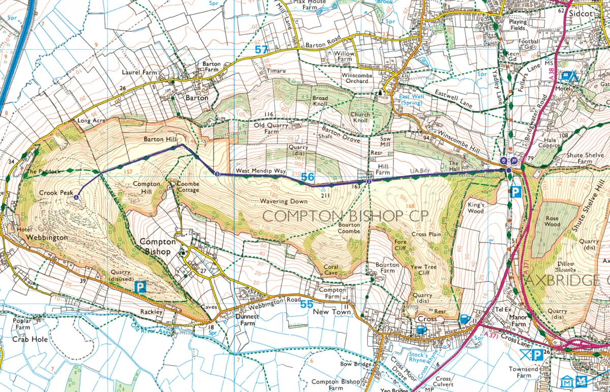
Crook Peak map
Crook Peak walking route and map
Useful Information about Crook Peak
HOW TO GET THERE
By road, King’s Wood is just off the A38, about a mile south of Winscombe and the junction with the A371. Turn off Bridgwater Road (A38) on to Winscombe Hill for the National Trust carpark.
By bus, the 126 Weston-super-Mare to Wells service stops at Winscombe Hill. By train and bike: The Strawberry Line starts at Yatton railway station (which is just a 15 minute hop from Bristol Temple Meads) and runs very close to King’s Wood.
FIND OUT MORE
Visitor information
Get a Mendip Hills visitor guide
01761 462 338
EAT
The Crown Inn
Award-winning unspoilt country pub serving local ales and hearty home-cooked food.
The Batch, Skinners Lane, Churchill BS25 5PP
01934 852995
NEARBY
King John’s Hunting Lodge
The Square,
Axbridge BS26 2AP
01934 732012
www.nationaltrust.org.uk/king-johns-hunting-lodge
This early Tudor, timber-framed, wool merchant’s house is now a fascinating local history museum.
MAP
OS Explorer 153
Grid reference: ST 387 558
OS Explorer 141 for King’s Wood (Grid reference ST 422 561)