
A team led by Cambridge University has used aerial, AI-supported maps to survey a huge area of Cairngorms National Park in Scotland and document the regrowth of native woodland.
These maps cement the success of Cairngorms Connect, a partnership of land managers that are committed to a 200-year environmental project. The aim of this vision is to enhance the flora, fauna and ecological processes within the park.
The Cairngorms is the UK’s largest National Park and stretches over an incredible 4,528 square kilometres. Featuring an array of breathtaking natural landscapes such as ancient woodlands, impressive mountain ranges and mystical lochs, the area is steeped in Scottish culture and history.
The park’s primary intention is to promote and conserve the natural heritage of the space and promote sustainability in their endeavours.
However, the Cairngorms has faced its share of severe challenges. Dealing with cataclysmic natural disasters like wildfires and issues caused by anti-social behaviour as a by-product of over-tourism, the natural landscape has suffered enormously.
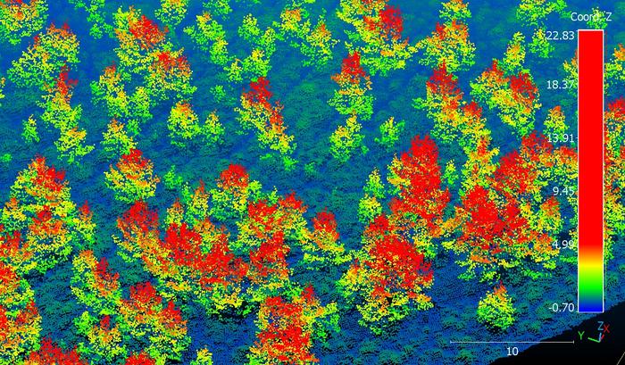
New technology has now proved that Cairngorms Connect have not failed in their quest for revival. From a light aircraft, a laser scanning tool known as LiDAR collected information that the Cambridge team processed. Their brand new, AI-supported data analysis method documented over six million trees, and their heights, across the 569 kilometre survey area.
“The ability to map regenerating trees so precisely, at such a huge scale, is a breakthrough for monitoring nature restoration at a landscape scale,” Dr Aland Chan, from the University of Cambridge’s Centre for Landscape Regeneration and co-leader of the project said.
“It means we can effectively map young trees, assess whether restoration targets are being met, and inform future restoration work.”
The results prove 2.65 million trees (over 40% of those surveyed) were small, newly growing trees. This exciting discovery indicates the incredible regeneration and expansion of existing forests and how the land is developing, despite its hardships.
“The new LiDAR-based method is excellent at tracking where new woodlands are establishing across the landscape, and also for tracking the impacts of fires - which are increasing in severity with climate change,” Said Dr Pip Gullett from the Cairngorms Connect partnership.
“This is going to be a great way to monitor large-scale woodland expansion going forward, as more and more landowners across Scotland are looking to re-establish native woodlands.”
The data revealed is also useful for aiding future progress as it found that differences in landscape matter for regrowth; the new trees were more prevalent in dry areas rather than wet, boggy ones.
