Rising as it does in a giant mountainous sponge and ending in the turbid Severn Estuary doesn’t make the Wye sound especially alluring. Nevertheless, whether tumbling clear as glass through the Welsh hills or wending lazily round the broad bends and horseshoes of its lower reaches, it is an astonishingly beautiful, sensual, even sexy river.
And, continuing the metaphor, like any good partner it offers variety to keep you interested, with frissons of excitement and inspiration along its entire route. It is packed with the sort of wildlife to keep nature lovers in a constant state of excitement. Geologists, archaeologists and historians will have a field day. Outdoor pursuits enthusiasts will be in their element, whether canoeists, walkers, bikers, climbers or cavers. No wonder then that it was recently voted the nation’s favourite river.
The prettiest route
First off, a few facts. The Wye is 136 miles long, setting off on its journey from the slopes of Plynlimon, Ceredigion, also the source of its sister rivers, the Severn and Rheidol. Of the three it is said the Wye chose the prettiest route, heading south through Powys, then Herefordshire before nibbling the borders of Monmouthshire and Gloucestershire.
From Monmouth to where it pours into the estuary at Chepstow, the centre of the river forms the boundary between England and Wales. This can be a tad confusing for travellers and lead to an odd feeling of “what country am I in?” at times. It’s a headache for the emergency services as well. Break a leg on the banks of the river in Monmouthshire and you’re liable to get ambulances from Gloucester or even Bristol.
But to begin at the beginning. Getting to the source of the Wye is no mean feat. It is about eight miles from the nearest town or village and there’s no public transport. So unless you’ve got your own car or can arrange for friends or a taxi to pick you up, you’re in for a long there-and-back trek.
Plynlimon itself is a giant rain-soaked lump of a mountain rising to 752m (2,467ft). In effect it is one massive acid grassland blanket bog with outcrops of dwarf shrub heath. It’s also an important upland areas for nature conservation and you should see buzzards, red kites and peregrine falcons aplenty.
Sorry to say, the source itself isn’t exactly overwhelming. Robert Gibbings, in his 1942 book Coming down the Wye, described it as “a pool no bigger than a bowler hat.” You get the picture.
Heading downstream, you’re entering sheep farming territory now and the first village of any size is Llangurig, reputedly the highest village in Wales. It is an attractive smattering of cottages and a couple of pubs that are very welcome in this remote landscape. Flowing south, the river is pent up within close rocky banks with a succession of waterfalls.
Rhayader is the first large settlement. The name means ‘the fall of the Wye’ and there was once a large waterfall here, but it was cleared to widen the river and construct a bridge. A bustling market town, Rhayader is a mecca for mountain bikers. Many follow the old railway track, now a cycle route, down to the Elan Valley. In August the mountain slopes are aflame with heather and the reservoirs themselves are well worth visiting – water is gravity-fed all the way to Birmingham, something of a sore point for the Welsh.
Rhayader had a turbulent history when a secret society was formed to destroy tollgates in the 1840s. Gangs of men blackened their faces, dressed in women’s clothes and went out to cause havoc in incidents known as the Rebecca Riots. The Rebeccas later turned their attention to spearing spawning salmon at night.
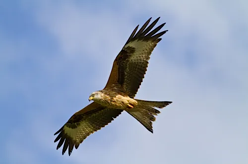
On the outskirts of the town it is worth detouring to Gigrin Farm, where red kites (pictured below) are fed daily. Rhayader was at the centre of the resurgence of this near-extinct raptor and the sight of hundreds of them floating over – and squabbling with the buzzards – is one of our great wildlife spectacles.
Builth to Ross
After a series of rapids at Penddol Rocks, the river reaches handsome Builth Wells, home of the Royal Welsh Show. As the name implies, a pump house in the town used to dispense saline, sulphurous and chalybeate mineral water – a penny for as much as you could drink in 1904.
Crossing the border at Hay-on-Wye, renowned for its annual literary festival in May, the river enters Herefordshire and changes character completely. Running beside rich farmland, it broadens and changes colour markedly. After rain it becomes a reddish brown, the consequence of alluvial run-off most often blamed on potato farming.
Passing through Hereford, the river heads to the market town of Ross-on-Wye. Ross, curiously, was the launch point for the first form of package tourism in Britain, with boat tours taking the likes of Wordsworth, Coleridge and the painter, Turner downriver. These were the brainchild of Dr John Egerton, who built a boat in 1745 to take his guests on excursions. The trip was popularised by William Gilpin’s book Observations on the River Wye and several parts of South Wales. He wrote: “If you have never navigated the Wye, you have seen nothing.”
The book was a bestseller and trips down the Wye soon became the rage among aficionados of the Picturesque Movement. Boats mostly started from Ross, making their way down to the tidal stretches below Brockweir to the then port of Chepstow – a route taken today by thousands of canoeists. The Wye is peculiar in that there is a right of free navigation along its waters, which has always ruffled feathers among fishermen, bailiffs and landowners, especially when canoeists make landfall away from official launch points.
You are now entering the most familiar picture postcard stretch of the lower Wye as the river sweeps in a series of dramatic horseshoes beneath towering limestone cliffs and through some of the most spectacular ravine woodlands in the country, with buzzards mewing plaintively overhead. Initially the river flows from Ross in a fairly straight line towards Goodrich. In sunlight the fields to the right often shimmer like a lake because of the reflection from the polytunnels growing salad crops.
Further downstream you pass the mighty, square Norman keep of Goodrich Castle, commanding a wooded hill beside the river. Built by Richard ‘Strongbow’ de Clare, the Earl of Pembroke in the 12th century, it is now run by English Heritage, and is a perfect place for a game of hide and seek.
After Kerne Bridge, the Wye loops alongside dense woodland and open pasture past the Forest of Dean village of Lower Lydbrook and Herefordshire’s Welsh Bicknor. The buildings to the right are an abandoned church and a former rectory, now a youth hostel. The industrial complex to the left once made cables that ran under the Atlantic.
Beyond lie open fields and then Symonds Yat: two hamlets, East and West separated by the river and mounting the hills like Alpine villages. High above on a limestone pinnacle is Symonds Yat Rock, where you are likely to see breeding peregrine falcons. The RSPB has a viewing platform on the rock.
The Yat is a meeting point for canoeists, cyclists and hikers. The rapids are an important training ground and the Peregrine Path cycleway runs along an old railway track into Monmouth.
Whether you’re cycling, walking or canoeing, the woodlands have now closed in beside the river, the trees overhanging the water creating an almost Amazonian feel. On either side you’ll be able to glimpse the light grey scars of limestone crags.
In the densely wooded hinterland on the Herefordshire side is a humpbacked dome called the Doward, where a hill fort has recently been excavated. Remains of ‘picturesque’ viewpoints created by a South Wales ironmaster have also been identified by Herefordshire Council archaeologist, Neil Rimmington.
The wood on the Gloucestershire side, including Highmeadow Woods and the National Nature Reserve of Lady Grove are protected for their rare tree species. Stay long enough and you’d be unlucky not to see fallow deer, while tiny muntjac deer are also now moving in.
Beyond bustling Monmouth, the river increases in pace. The woods press ever closer and it is said that a squirrel can make its way from Monmouth to Chepstow without touching the ground.
Former industrial villages lie on either side of the river such as Redbrook, so called because its streams were reddened by iron ore. A tinplate works was still operating here until the 1960s, used in the making of tobacco and confectionery tins.
A mile or so downstream lies Whitebrook, so named because its waters ran white from the washing of rags shipped from Bristol for its paper mills. Paper from Whitebrook was once used to make banknotes.
You’re now in a stretch of prime fishing territory. The Wye is noted for salmon as well as the twaite shad – a second cousin of the herring. The Wye and Usk Foundation, which monitors catches on the river and its tributaries, says that after some disastrous years, the river has a very healthy fish population and salmon numbers are up.

To the sea
Moving faster downstream, you’ll reach Bigsweir Bridge where the tidal river starts. Back in the 1980s this area saw some ugly scenes during the elver wars, as elvermen armed with nets and lamps tussled over pitches. There was good money to be made selling the baby eels to Spain, where they are a delicacy.
It is at this point that wild boar, which have recently returned to the Dean (more than 150 were culled last year), have been seen swimming the river, crossing into Welsh woodlands as far as Trellech.
The river flows on past the villages of Llandogo and Brockweir (pictured above). Both once specialised in building the shallow bottomed ‘trow’ barges that plied their trade up the Wye and Severn. It was above Llandogo (on the Welsh side) at Whitestone that William Wordsworth was inspired to write his Lines composed a few miles above Tintern Abbey. Tintern, an 11th-century Cistercian Abbey, has to be one of the most beautifully situated ruins in the British Isles. The audio tour is suitable spooky.
Beyond Tintern, around Ban Y Gor, the woodlands close in again. This is an eerie place, haunt of cormorants, shelducks, herons and otters.
Finally, the river opens past the sheer Lancaut cliffs to emerge under the crags of Chepstow Castle, the first stone built castle in Wales, begun in 1067. In the sheltered waters in the shadow of the castle you might be lucky enough to see the odd seal.
With one of the highest tidal ranges in the world – sometimes the river flows backwards towards Tintern, pushed by the strength of the tide – the Wye is now racing headlong towards its end.
It sweeps under the graceful old Wye Bridge where the widders from Wales and the English morris men meet in the middle, under Brunel’s tubular railway bridge, past the old docks and out to be swallowed in the wide expanse of the Severn Estuary.
