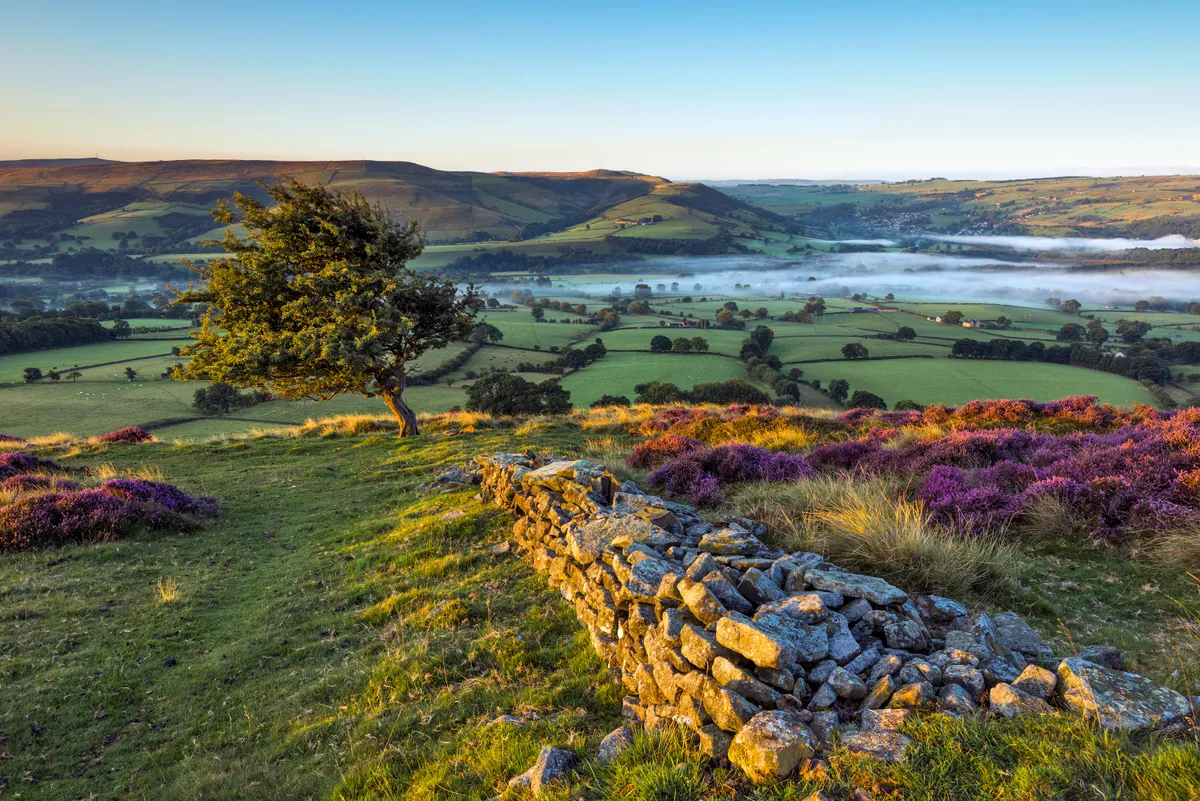
A quirk of geology has produced a strand of sharp limestone hills which erupt like a string of vertiginous miniature mountains from the haymeadows and soft pastures of the higher Dove Valley, near Buxton.
The Dragon’s Back range are often cited as the only true peaks in the Peak District; a line of pinnacles said to resemble the ‘plates’ along the spine of a stegosaurus dinosaur.
This moderate-level, 5.4-mile walk in the Peak District starts and ends at Earl Sterndale, taking in Parkhouse Hill, Chrome Hill and the hamlet of Hollinsclough.

Chrome Hill walk
5.4 miles/8.7km | 3.5 hours | moderate
1. Earl Sterndale
Begin at the now-closed Quiet Woman in Earl Sterndale, a 400-year-old pub with hand-painted signs of a decapitated barmaid. Take the path behind the pub across fields.
2. Hitter Hill
Round Hitter Hill to cross the B5053 to Parkhouse. The path winds steeply to the top.
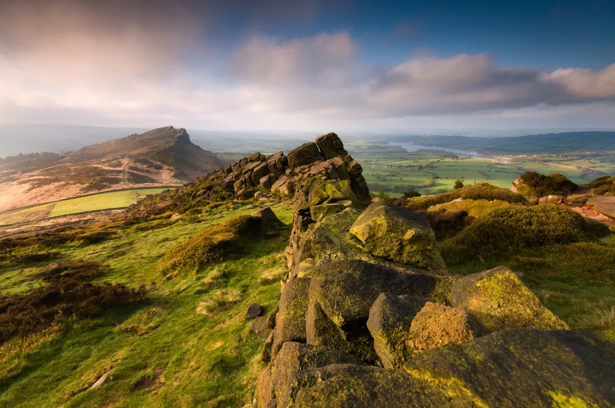
3. Parkhouse Hill
On the ridge, it feels like you are balancing on the serrated back of a dragon. Below, the bumps of hills and river valleys ripple out to the horizon. It's hard to imagine this rain-softened English landscape once lay under a tropical sea; the grassy hills of Parkhouse and Chrome, the remains of an atoll.

4. Chrome Hill
The way off Parkhouse Hill is extremely steep. Start just left of the ridge-top before crossing to the right, dropping to a minor road. Turn right to the nearby cattle-grid. Immediately before it, use the stile onto a path for Chrome Hill and High Edge.
The path rises over hummocks of limestone to reach a handgate beneath a tree, then climbs to the summit ridge.
Discover more walks in the Peak District
5. Hollinsclough
Advance along the declining ridge; beyond a low arch, drift right, steeply down to find a wall-side way and bend left with it to use a corner handgate. Follow signs to another handgate; then turn uphill, shortly heading left along the top of pastures, keeping Tor Hill on your left, to reach a cattle-grid and farm road.
Follow the footpath diagonally left, crossing fields. Keep Stoop Farm on your left. The way skirts the base of Hollins Hill, dropping to the quiet hamlet of Hollinsclough with its old school house and bell tower.
5. Back to Earl Sterndale
Turn left in the centre of the hamlet down a single-track road. Look for a footpath sign just beyond a small building and track on the left. Take the path alongside a sparse line of trees (on your right), turning right onto a track, which then joins a single-track road beneath Parkhouse Hill.
Cross straight over and, keeping the hill on your left, wander across the grass to rejoin your outbound route back to Earl Sterndale.
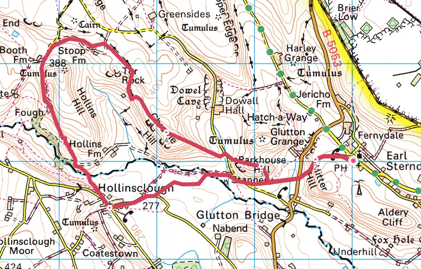
Chrome Hill map
Parkhouse Hill and Chrome Hill walking route and map
Read our roundups of the best walking shoes and the best walking boots for our team's take on the best outdoor gear.