Starting in Hathersage at the George Hotel, Main Road (A6187), the walk goes through the village and then ascends steadily up to Stanage Edge, walking through fields, woodland, open moorland and then through the boulder field to enjoy the magnificent views from Stanage Edge.
Keeping the height gained, the walk continues through prehistoric settlements and magnificent eroded gritstone outcrops to return into Hathersage. Ascent 550m.
Parking
Hathersage (S32 1DD) and the rail station (S32 1DT).

Hathersage, Stanage Edge and Higger Tor walk
8 miles/13km | 6 hours | challenging
1. Hathersage to Birley Lane
With your back to the George Hotel turn left, heading into the village passing a blue plaque for a local philanthropist, George Herbert Lawrence (1844 -1940). Walk past the shops bearing left up Besom Lane then turn left into Baulk Lane.
G H Lawrence (1888 – 1940)
A successful Sheffield razor blade manufacturer who made Hathersage his home and made generous gifts to Hathersage and Sheffield.
On the night of 13th December 1940, during the Sheffield blitz, G H Lawrence drove to his Sheffield factory on Nursery St, with a delivery of food and drink for his employees. The shelter he and his employees were in received a direct hit from one of the bombs and many, including G H Lawrence, were killed.
His many gifts to Hathersage included funds for the open air swimming pool and bowling green, which still exist, and to the Methodist chapel.
As a director of Sheffield United he paid for the roof to be put on the kop. He made a gift to an outdoor swimming pool at Longley Park; now no longer existing.
Follow Baulk Lane for 1.4 km, passing a view of the spire of St Michael’s Hathersage church on the right, with the cricket ground, scout hut and allotments on your left.
The track continues over a cattle grid, crossing open fields which reveal long distance views of Stanage Edge on the horizon. Go through several field gates and then, with stone buildings ahead in view, take the left fork downhill at the finger post (GR 232 827).
Continue downhill through a stone squeeze stile with a small wooden gate. The path follows a wire fence on the right and, after reaching a stone wall on the left, you will soon encounter Brookfield Manor. After passing through a small wooden gate the path meets the road (Birley Lane) after 80m.
2. Birley Lane to Dennis Knoll (Long Causeway)
Cross the road (GR 232 831) to the stile opposite. Walk through the field and wooded area and after 250m reach a wooden bridge, which you cross, over Hood Brook. Walk through the trees and fields, crossing a stream via a wooden footbridge, and after 350m pass through a gap in a stone wall to a lane (GR 229 837).
Turn left then turn right at a finger post, uphill, through a wooden gate. Follow the path uphill to meet a gateway on the right (100m). Take the track (GR 228 838) keeping the stone wall on the left. After 80m cross the stone stile in the wall (GR 229 839). After 200m uphill you will pass a conifer plantation then after 100m (GR 229 843) meet the road. Turn left on the road then right up the track, Long Causeway (Dennis Knoll car park – GR 227 843).

3. Dennis Knoll (Long Causeway) along Stanage Edge
This trackway is part of the Roman road / packhorse routes between the Roman camp at Navio and Templeborough near Rotherham.
When the track becomes level, continue for 75m (GR 238 845) then take a path, at a low wooden post (access land), to bear right along Stanage Edge. Continue for 1.4km to reach a white trig point, without taking any paths down to the right off Stanage Edge.
As the edge gains height before the white trig point (Alt 451m - GR 250 830) take the indistinct path to the right which becomes a broad path down to the tarmac road (The Dale) and parking (300m). Soon there is a small group of pulp grindstones (GR 250 829) to the left. Cross the road (GR 253 825) and through the gate opposite bearing left to cross open moorland to the next road (350m). Cross the road and walk uphill to enter (GR 257 819) Higger Tor.
Millstones and Grindstones
There are 1,000+ mill/grindstones scattered below the edges of Stanage, Burbage, Froggatt, Curber, Baslow and Birchen. They are a mix of millstones (flour), grindstones (blade sharpeners), edge runners (bulk material crushers) and pulp stones (paper production).
Produced from the 14thC they reached the height of demand in the 19thC and early 20thC but production steadily declined as white bread became popular and people didn’t want the discolouration of gritstone.
4. Higger Tor, Carls Wark and Owler Tor
Enter Higger Tor at its north west corner (GR 256 822) and cross the level plateau, strewn with flattened boulders, keeping to the left to reach the corner of the plateau.
There is no evidence of Higger Tor being a settlement or occupied but it has strong defensive properties, with nearby Bronze Age cairns, field systems and artifacts.
At the left (south east) corner of the plateau, take the path which begins after the rocks and boulders strewn at your feet, down to Carls Wark fort (450m). If the weather is wet or foggy, the ground after Carls Wark will be boggy so you may want to walk directly to the rectangular sheepfold (40m x 100m) 300m to the right, from the plateau.
The entrance to Carls Wark is marked by a wall of boulders (GR 258 815). Without going into Carls Wark keep the boulder wall on the left and walk 50m to a stone plinth (GR 258 814). If you cross the boulder wall after the stone plinth you will see the original entrance flanked by stones.
If time permits it is worth spending a few minutes exploring Carls Wark – a fort occupied by humans from at least the Saxon period and possibly the Neolithic/Iron Age.
5. Carls Wark to Over Owler Tor
From the stone plinth the route goes to the sheepfold between two rocks (40m). You soon meet a junction of paths; bear right downhill. The path becomes indistinct and boggy so several small paths exist, but keep heading to the sheepfold with a series of small rocky outcrop ledges on the left 250m away.
From the left corner of the sheepfold (GR 253 814) take the path left heading uphill from the sheepfold. Head towards a rocky outcrop and after 600m (GR 251 808), the path rises onto the rocky outcrop.
After 100m the 10m tall rock outcrop of Over Owler Tor is met (GR 250 807).
6. Over Owler Tor to Whim Wood
Follow the path bearing left and after a few metres take a path downhill (GR 250 806) to the right just before a weathered millstone grit boulder. The lone large rock ahead (100m) is Mother Cap.
After 150m at a fence turn right. Over the fence is Millstone Edge. As the path leaves the fencing on the left, it goes sharply left downhill. Walk through a gate onto the National Trust owned Little Moor, to reach a road after 500m (GR 244 808) at the corner of Whim Wood.
As you descend Millstone Edge is over the fence to the left. It is a former quarry for gritstone blocks and millstones. With its vertical cliffs of smooth gritstone it often has climbers on it. There is evidence of the explosives and wedge marks showing how the blocks were removed, and dozens of finished but abandoned millstones.
4. Whim Wood to Hathersage
After the stone stile, cross the road right (35m) to a gate and finger post. Continue up the tarmac drive for 200m and as it bends right, at the stone gatepost (GR 242 811), bear left on a level footpath with a stone wall to the left.
After 100m woods are reached (GR 241 811) and the route continues downhill through a gate, with a stone wall on the left, through woodland. After 250m a track and housing are reached (GR 237 811). The main road (A6187) is reached after another 250m (GR 234 812). Turn right and follow the road downhill for 500m into Hathersage and return to the start.
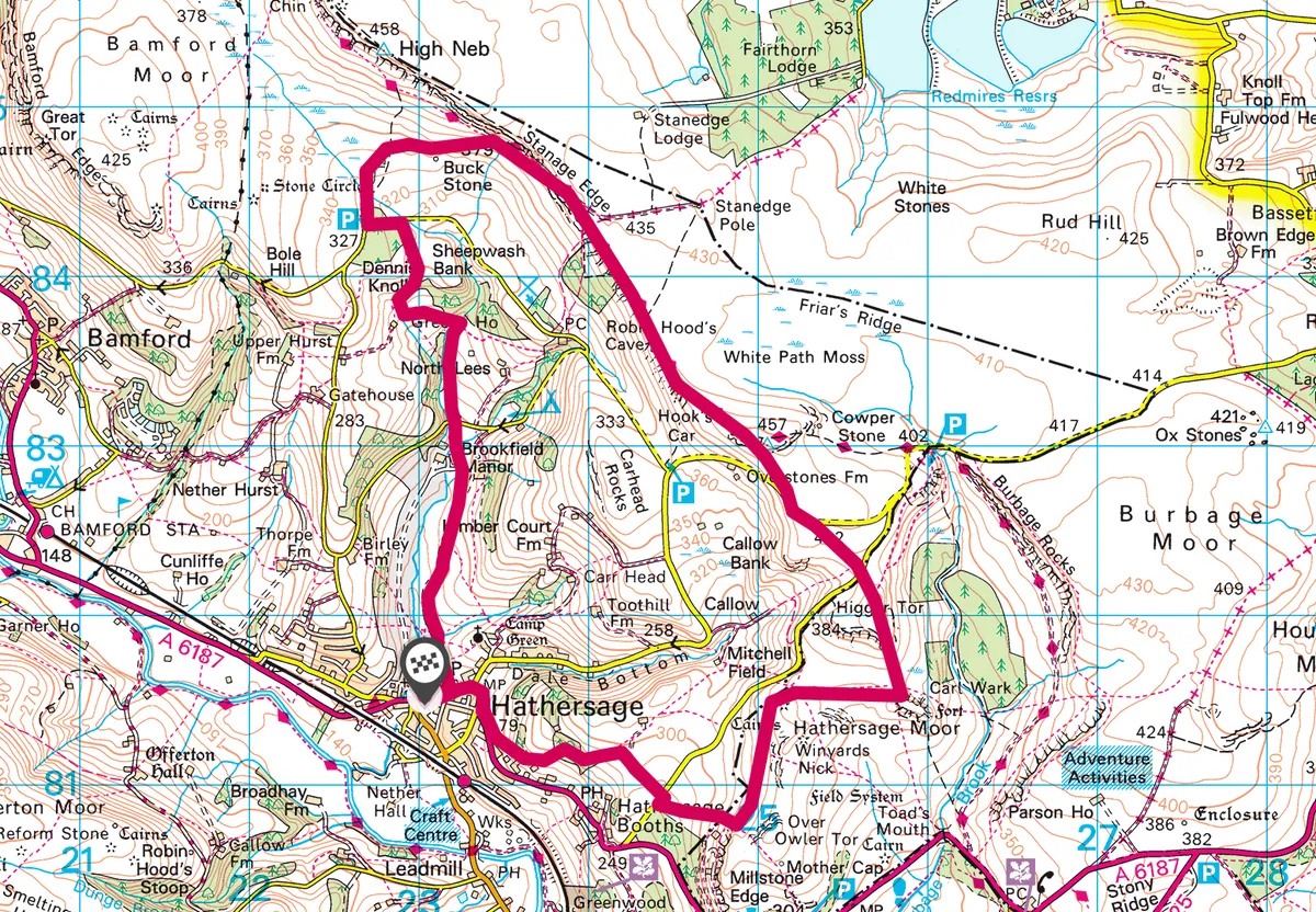
Hathersage, Stanage Edge and Higger Tor map
Hathersage, Stanage Edge and Higger Tor walking route and map
We are a Sheffield family and with James, and his brothers, spent many days walking in the Dark Peak's valleys. The walks in this book are a mix of high and low level, short and long and include five linear walks where the start and finish can be completed by the local stopping train. The five walks are 6-8 miles each and make up the original James Brownhill Challenge (JBC) walk which was 22 3/4 miles long; a mile for each year of his life.
There are a further 13 round walks and each walk is referenced to the other walks, where they are met, to allow readers to build their own walks.
There are is background information on the local history and geology of the valleys and the Dark Peak, with a separate piece about the social and industrial history of Stanage Edge.
It is spiral bound to allow it to be taken on walks, it includes maps and lots of grid references. There are points of interest on each walk to help put the location in context of it's place in history.
The profits from book sales will go to the James Brownhill Memorial Fund (www.JBMF.co.uk), which provides bursaries each year to pay for University volunteer climbing club leaders to attend training course for leading winter mountain climbing trips.

