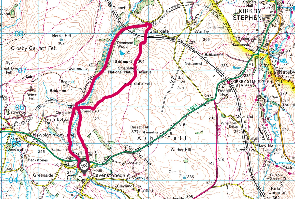
A rivulet gushes from springs high on Wild Boar Fell in the Yorkshire Dales National Park. Surging through quaint, ancient Ravenstonedale village as Scandal Beck, it threads northwards, foaming into a cavernous gorge before joining the River Eden and the Solway Firth below Carlisle.
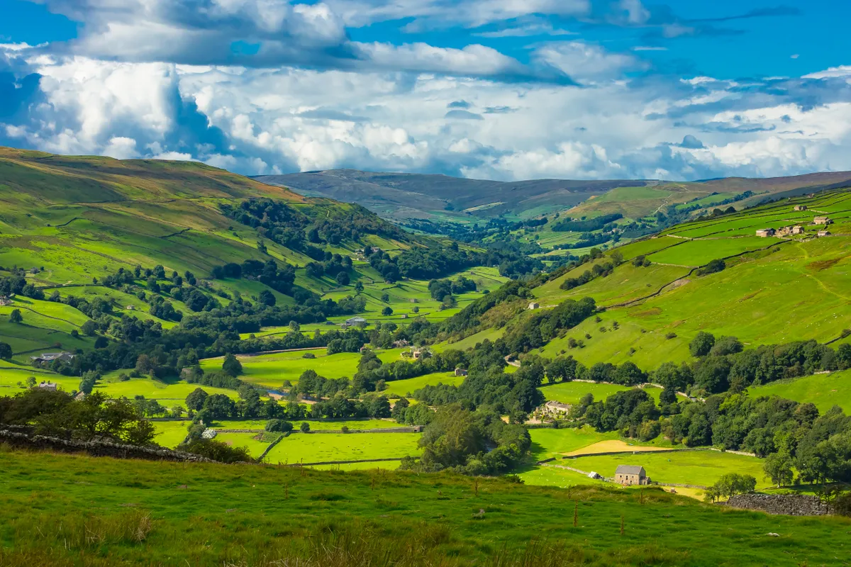
This magnificent, relatively unknown limestone landscape became a part of the Yorkshire Dales in the 2016 boundary extension. It oozes the character of a time long-gone. Sheep farming keeps the uplands open, tiny villages and hamlets claim the more sheltered locations and wildlife prospers. Wild birds, aquatic denizens and myriad mammals, insects and floral beauties conspire to enhance this natural wonderland, protected, in part, as the Smardale Gill National Nature Reserve.
Enjoy a spectacular seven-mile walk through a secluded gorge in the Yorkshire Dales National Park with our plotted walking route.

Remote from any road, this deep gash in the flank of the Pennines’ undulating uplands slices through the fells as a memorable chasm, richly dressed by broadleaf woodland. While roads are absent, a footpath utilises the spectacular abandoned railway viaduct that leaps across the depths, offering a drones-eye view into the rift. The walkway then heads through woods, home to red squirrels and birds of prey. This superb figure-of-eight walk is completed with a high-level return on airy moorland bridleways.
Smardale Gill Viaduct walk
6.8 miles/11km | 4.5 hours | moderate
1. Ravenstonedale
From Ravenstonedale school (park in the road triangle), walk the lane, keeping the church on your left. Turn right at a junction and cross the waymarked stone stile on the left beyond the nearby cottage. Near the far-left field corner, descend steps and cross the fast A685 into more pasture. Join the field road ahead.
Beyond the smaller barn, aim for the left corner of the plantation. Use the gate and keep ahead (towards a skyline of firs) to a gate-side stile. Head downstream beside Scandal Beck to reach the old drovers’ track above Smardale Bridge. Keep eyes peeled for dippers in the water, or perhaps native crayfish or an otter.
Here stood a pub known as the Scotch Inn, named after Scots drovers who passed by (until the middle of the Victorian age) with their herds of cattle and sheep en-route to the markets of central England. It’s thought that plotters, set on overthrowing King Charles II, met here in 1663 – the ‘Kaber Rigg’ conspiracy came to nothing, and the revolutionaries, led by the redoubtable trooper Captain Atkinson, were later executed.
Cross the superb packhorse bridge and turn right (signed C to C). Step through a bench-side handgate on to the old railway trackbed. Turn right to pass beneath the over-bridge and advance along the dismantled railway. In its heyday it was a vital route across the Pennines, linking the industries of Teesside with Lancashire over the formidable Stainmore summit – the line closed in 1962. In the 1990s, it became a linear nature reserve, at the heart of which is the striking, curving viaduct at Smardale Gill. Before reaching this, explore the remains of the huge lime kilns above the track beyond abandoned cottages.
2. Smardale Gill Viaduct
The memorable path in the sky crosses 14 arches nearly 30m above the beck – look back for an exquisite view of the distant Howgill Fells. At the far end of the viaduct, it’s worth turning back-right on paths to experience the wildflower-rich pasture. Bluebells, rock-rose, orchids and scabious occur in great drifts, attracting myriad butterflies for which the reserve is renowned – dark-green fritillary, common blue and Scotch argus are just the tip of the lepidopterist’s iceberg.
Return to the trackbed and continue northwards through the woods past a series of information boards, keeping an eye out for browsing roe deer and red squirrels. Wood warblers, nuthatches, pied flycatchers, redstarts and buzzards also share the trees.
The track soon passes below the route of the Settle-Carlisle Railway, advancing past the site of a 1955 train crash.
")
3. Smardale Hall
Continue to the car park at Smardale hamlet. Bear left to the house beside the lane and turn right, then right again over the bridge beside the old station at Smardale, abandoned in 1952 and now a residence. The next right takes you on a ‘dead-end’ lane into Smardale. Beside you is the formidable Smardale Hall, a fortified tower house dating in part from the 14th century.
Pass under the main line again and advance to the lane’s end amid cottages. Join the bridleway signed for Brownber and rise beside the wall, curling left uphill to use the gateway visible at the top of the field. Beyond here, pick up the line of a wall, cresting near a corner beyond a second gate. Look back for a grand prospect of the North Pennines.
4. Smardale Fell
Keep company with the wall – the bridleway soon points towards Smardale Bridge. It’s a highly enjoyable trek across the shoulder of Smardale Fell, with the Howgill Fells a tremendous horizon. Scattered across the moors are the scant remains of ancient settlements, and evidence of long-gone farming practices such as bracken-drying and rabbit farming. Beyond the tree clump, the way descends past a sheepfold to reach a wide, walled track down to the old bridge at Smardale. Cross the bridge and walk up the track for 75m to a handgate signed for Ravenstonedale.

5. Kings Head
Head up the pasture to the large plantation. Cross a stile to the left of the trees and follow the path beside a double-fence. Zigzag down the tongue of the hill, cross a flat bridge over a beck, then stroll up to the field road. Go left and look diligently for a handgate on the left above a stone hut. Drop to another gate beyond and turn right below trees. Take the next handgate gate on the left to meet the narrow beck-side path, heading upstream to join a tarred lane ahead into Ravenstonedale. Go left to the Kings Head, then turn right back to the school and car park.
Smardale Gill map
Smardale Gill walking route and map