Upper Wharfedale is a charming little valley off the beaten track where the roads are too narrow for trucks and busses to navigate. It's a bit of a bind to get to, but once you've found the dale, you'll never forget it.
The limestone and peat uplands hereabouts are riven with steep-sided valleys and ghylls where water teems off the fells and tumbles over a series of waterfalls through the heart of the picturesque villages of Cray, Yockenthwaite and Hubberholme.
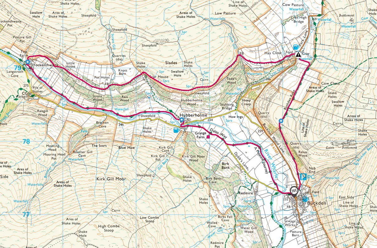
Follow this walking route in Upper Wharfedale in North Yorkshire with a plotted OS map.

Upper Wharfedale walk
7 miles/11.2km | 4 hours | moderate
1. Buckden Pike
Park in the National Trust car park just off the B6160 and follow the limestone track climbing steadily north through the scrubby hawthorns on the flank of Buckden Pike.
After 10 minutes' ascent, the path levels out, offering excellent views of the surrounding valleys and the higher limestone edges and terraces of the Dales. At the gate, stay left, ignoring the path up to the summit of Buckden Pike and continue along Buckden Rake towards Cray at the head of the valley.
Cray appears to the left as the track descends to a gate. Take the path to the left, descending the steep limestone terraces then crossing the stepping stones into Cray. A short detour into the Gill is in order before returning to the White Lion.

2. Yockenthwaite
Take the footpath round the back of the pub signposted Stubbings Bridge and Yockenthwaite and continue along the lip path, admiring the views of the terraced limestone sills laid down in warm tropical seas hundreds of millions of years ago.
At Scar House, take the left hand track up into Langstrothdale, a remote valley which was once a medieval noblemen’s hunting ground or ‘Chase’. After the ruined barn, take the footpath through the wall to descend to the farming hamlet of Yockenthwaite.
3. Hubberholme
At the crossroads in the farmyard above the elegant stone bridge, stay on the north bank of the river and follow the Dalesway to Hubberholme. The path hugs the river, following moss-capped walls past a chain of rugged stone hay barns.

4. Buckden
At Hubberholme, the Norman ‘Forest Chapel’ of St Michael’s and All Angels beckons visitors to admire its rare oak rood screen carved by Robert Thomson. The church is the last resting place of the writer JB Priestley and across the river, the George Inn was a favourite watering hole of this proud Yorkshireman. Cross the bridge to follow the road along the south bank of the river then take the path left to follow the river back to Buckden.
Upper Wharfedale map
Upper Wharfedale walking route and map