Most of us will never forget the spectacular images of the floods in Boscastle during August 2004. Exceptionally heavy rain caused both the Jordan and Valency rivers to burst their banks, sending floodwaters crashing down the valley into Boscastle village causing millions of pounds worth of damage.
It took four years of restoration and building work to return the village and surrounding area to the state they were in prior to the deluge.
This easy walk follows the Valency River through the beautiful valley that bore the brunt of the flooding. Along the way you’ll find a church and wander through the old part of Boscastle before heading back to the harbour via a stunning stretch of the South West Coast Path.

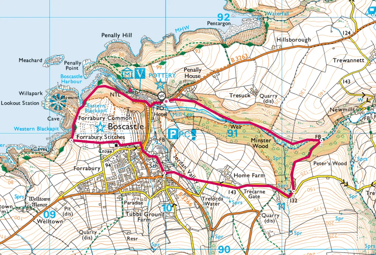
Follow our walking route with a plotted OS map, which starts and finishes in Boscastle and explores the local woodland and valley.
1. Along the River
The walk starts next to the Valency Holiday Accommodation, just off the B3263. Go through the gate next to the B&B and head along the footpath. You’ll pass through another gate and then find yourself walking up the valley along the right of the Valency River. On 16 August 2004, an estimated 20 million cubic metres of flood water came crashing down this valley before causing havoc in Boscastle.
Follow the footpath as the river winds away to the right and enter the Valency Valley. Here, the wildness of the walk takes hold and there’s a different atmosphere with each passing month. In late March, the daffodils and primroses are in full bloom, just after the snowdrops, but in a few weeks, wild garlic and bluebells will be appearing.

2. A witch’s grave
At the footbridge, cross over to follow the path through Peter’s Wood, climbing fairly steeply up the valley slopes alongside gnarled trees covered in lichens. At the fork in the path, take the lower right path that leads down to the beautiful Minster Church secretly hidden below the level of the lane.
On the left before you reach the entrance to the churchyard’s consecrated grounds is the grave of a young woman, Joan Wytte, who was accused of being a witch. Known as the ‘Fighting Fairy Woman of Bodmin’, she died in 1813 and her skeleton had been on display in Boscastle’s Museum of Witchcraft until she was eventually buried here in 1998.

3. Across the fields
The tiny Minster Church is well worth a look inside. The oldest parts date to Norman times, with some late medieval additions and restoration work carried out in the 19th century.
On leaving the church, there’s a short climb up to the lane – look out for the Holy Well of St Madrun on the way. Turn right after the gate and walk along the road, while snatching glimpses of the coast ahead. At the next junction, bear right but pass by the lane on the left down to Home Farm.
The road continues downhill to a slate stile. Climb over it and cross the middle of the sloping field bearing towards the bottom left corner. Cross another stile, keeping to the left, and turn through a kissing gate (marked Old Boscastle). Then bear right along the stream, through a private garden to Butts Lane.
4. Old Boscastle
Turn right down Fore Street into old Boscastle, with its fascinating cottages and buildings. About half way down, take the one way road on the right and walk up to the B3263.
Cross the B3263 and take the smaller lane to the right of the large white house. Follow the tiny footpath through the trees, bearing left, which exits to Forrabury Common. Here, on the right are the Forrabury Stitches, a method of medieval crop rotation that still leaves its mark on the landscape in the form of a series of ridges across the fields.

5. Bracing sea views
Continue towards the coast and turn right to join the South West Coast Path. Straight ahead is the White Lookout Tower on the headland of Willapark. As the path curves to the right, look out for Profile Rock on Penally Point at the mouth of the harbour. In the hour before and after low tide, there’s a chance the ‘blowhole’ might be active… So keep watching.

Descend the slate steps and you can stroll along the quayside, walking past lobster pots and the new bridge, before heading back into the village to take some well-deserved refreshment.
Map