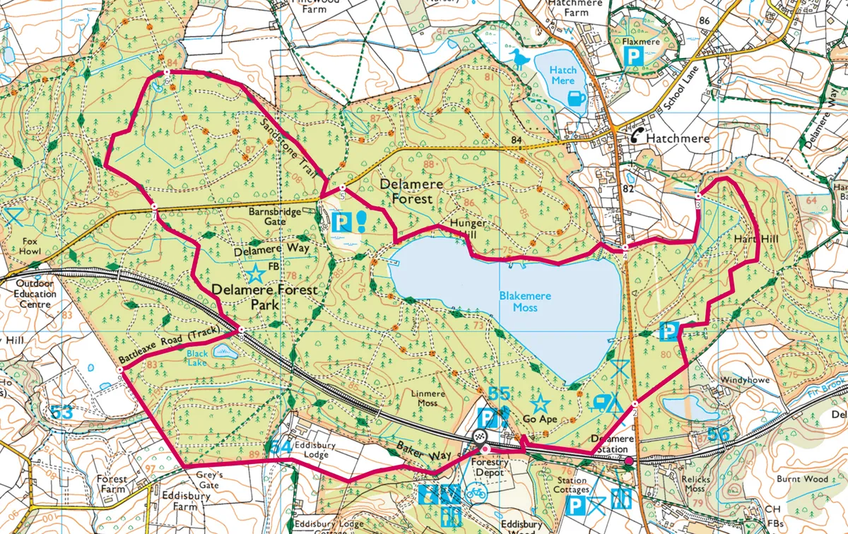
Graded forest roads offer easy ways to explore the beautiful the mixed woodlands of Delamere Forest. Here and there your paths cross primeval meres – atmospheric relics of the Ice Age.
This easy walk starts from the Forestry Commission Linmere Visitor Centre Car Park, near Delamere Station off the B5152.
Delamere Forest walk
6.2 miles/9.9km | 4 hours | moderate
1. Start
Return along the access road; 130m along, turn left over the railway bridge. Turn right and immediately right again on to a track that follows first the railway line, then turns north east, beside a camping ground, to reach the main road. Cross into the car park road opposite; on your right is the eerie Dead Lake, with its drowned trees.
More walking content:
2. Dead Lake
Enter the car park and turn right past the picnic area to a barrier. Join the gravel road beyond; in 70m go left on a wide path beneath soaring pines. Ease right with this, curling round to a fork (marked 21 on a post). Turn left and go ahead at the cross-track, continuing to a footbridge.

3. Brookside
Don’t cross this, but turn left alongside the brook. The path accompanies this woodland watercourse all the way to the main road.
For those who fancy a half-way lunch stop, turn right along the road for 1km to The Carriers Inn.
4. Blakemere Moss
Cross left to a barrier; turn sharp-right from this on the compacted roadway and walk to a major junction in 180m.
Turn left and trace this track beside Blakemere Moss. This area, reflooded in the 1990s, is more like the remote Canadian Shield than leafy Cheshire; the cacophony of terns is deafening. Viewing points allow memorable views, but keep well back from the miry foreshore.

Continue to and around a sharp-left bend marked with many waymarked posts. In a further 180m fork right on a short dirt path, then head right on a compacted path which meanders through lovely woodland to the main road at the entrance to Barns Bridge Gates car park.
5. Sandstone Tail
Opposite this (right) is a forest road. Join this and in 45m fork left on the Sandstone Trail. This then comes to skirt the forest edge.

6. Forestry Roads
At a cross-track keep ahead. Shortly, turn left on the wider track; in 350m fork left at the junction and then left again on a graded forestry road.
7. Southbound
At the main road go straight over and ahead-left on the principal track. Follow a bend round to the right; bear left at the next junction and walk 180m to a left bend. Fork right on to a path to reach a junction and railway bridge.

8. Over the bridge
Cross the bridge; go ahead 35m then left on a narrow path to find the Black Lake, a sombre pool overshadowed by immense pines.
Return to the main track and go left. Keep ahead-left at the fork and, at a sharp-left bend, go ahead on the lesser path through to a T-junction.

9. Complete the loop
Turn left on the path within the Forest’s edge; this dips and weaves through a dingle, rising past felled and regenerating tracts of wood, then past an orchard to gain a T-junction with a wide rough lane. Turn left and follow this back to Linmere.
Delamere Forest map
Delamere Forest walking route and map