Rising high above Exmoor, the East Lyn River flows through the East Lyn Valley in Devon to the picturesque village of Lynmouth.
With its splashing brooks, tranquil waterfalls and leafy trails, it is hard to imagine the tragedy that occurred here on 15 August 1952: flash floods swept through the valley towards Lynmouth, washing away more than 100 homes and killing 34 people. The riverbanks were rebuilt after the disaster, and today this waterside walk is quietly poignant in its calm beauty.

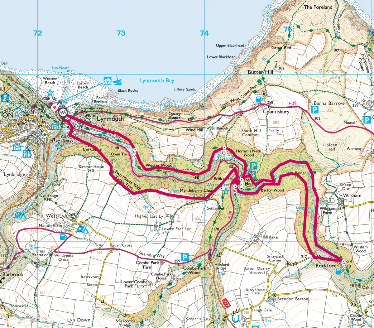
East Lyn River walk
6.8 miles/11km | 4 hours | moderate
1. Bridging the flow
From the Lower Lyndal car park in Lynmouth (toilet facilities available), walk along the East Lyn River to cross a white footbridge to the Tors Bridge road. Follow the path along the river until you see a sign for Watersmeet.
Whirlpools
Heading along the forest trail towards Watersmeet, you will see large mossy boulders in the riverbed, causing greenish blue whirlpools to form. If you are lucky, you might spot an otter or a kingfisher, but the river also supports salmon and trout, which attract birds such as herons and dippers. Thanks to the moist river environment, the ancient oak woodland is covered in a fascinating variety of lichen and moss, and at certain times of the year a colourful carpet of wildflowers and bluebells cover the ground.

2. Past reminders
Continue to follow the riverside path upstream towards the former fishing lodge and poetic retreat of Watersmeet. Cross the Blackpool Bridge to continue on the right side of the river, climbing upwards slightly at the fork to pass the former site of the Lynrock mineral water factory. Opened on the East Lyn in 1911, the factory made ginger beer and bottled mineral water until 1939, before finally being swept away in the 1952 Lynmouth flood disaster. A lone ginger beer bottle is set in the rock to mark the site.
3. To the tearooms
Continue along the ridge path past Myrtleberry, until you see an impressive arched stone bridge. Follow the sign towards the National Trust owned tearooms at Watersmeet.

4. River far below
Crossing the bridge at Watersmeet, follow the sign towards the small village of Rockford. The path rises high into the woods, leaving the roar of the river far below. Keep on the trail for 1.5 miles, gradually descending back towards the river. If you’ve worked up an appetite, the historic Rockford Inn has its own brewery and serves hearty pub grub.
5. Back to the coast
Return to Lynmouth on the opposite bank, crossing at Watersmeet before following the Two Moors Way and Tarka Trail to the coast. Alternatively, head towards Countisbury and join the coast path for a clifftop walk back to the car park.

East Lyn River map
East Lyn River walking route and map