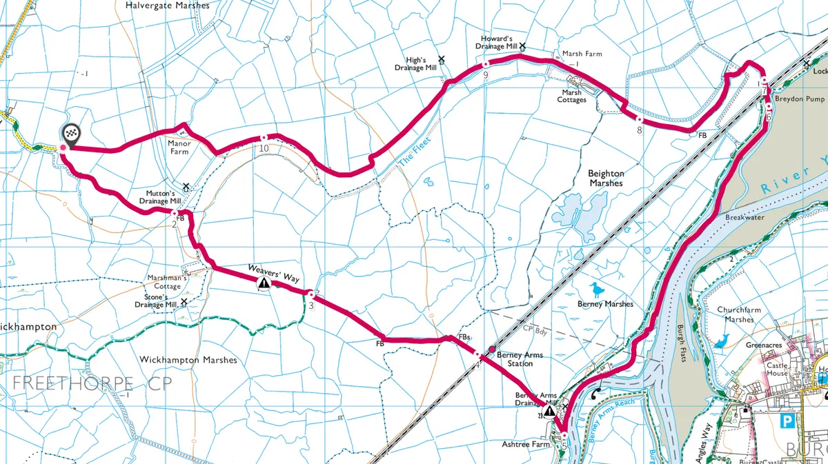
This route takes you through rustling reed-bordered marsh tracks and along the flood banks of Breydon Water where wigeon, shelducks and Bewick’s swans winter.
Explore this area with an eight-mile circular walk through Halvergate and Berney Marshes.

Halvergate and Berney Marshes walk
7.5 miles (12.1km) | 5 hours | moderate
1. Marshman
From Stone Road in Halvergate, take the track that leads to the right, straight into the marsh landscape passing Mutton’s Drainage Mill to the south. During the Roman period this area was an estuarine environment; the linear dykes and channels are evidence to centuries of drainage work and the importance of wind power to control the ever-changing water levels.
The path heads towards Marshman’s Cottage, with the redundant Stones’ Drainage Mill beyond, and continues to Berney Arms Mill, a long-standing focal point in this flat landscape. A track from Wickhampton meets the path from the right and, about 365m further on, crosses a footbridge with a gate on either side of the dyke. The route then enters cattle-grazed marsh to the railway line crossing at Berney Arms Station.

2. Sedge and reed cutters
The mill marks a transition from marsh to riverbank; originally the wind-powered mill ground a constituent of cement, before conversion to a drainage mill, assisting the reduction of marsh water levels.
Heading towards Berney Arms Pub (now closed), follow the path along the flood-protecting bank in a typical Norfolk Broads landscape – the realm of the sedge cutters. Sedge and reed cutting remains a centuries-old harvesting industry, the winter-cut reeds being used for roofing material on thatched cottages, churches and agricultural buildings. The more flexible sedge, harvested during the summer months, is used for roof ridge and capping locations. New and old drainage pumps dot the marsh landscape to the north as the tidal section of the River Yare to the south opens into Breydon Water.
The extensive mudflats are home to wintering wigeon, shelducks, Bewick’s swans and many other birds that enjoy this inter-tidal habitat. The culvert at Breydon Pump marks the end of the flood-bank trail, and the track drops down below sea level again and on to the marsh route.

3. Weavers Way
As the path follows the Weavers Way west through Beighton Marshes, the wide track is bordered by reed and sedge-lined dykes. The adjoining flood meadows are rich feeding grounds for flocks of curlew and open hunting land for short-eared owls. The Fleet channel forms a southern water boundary as the trail passes Howard’s and High’s Drainage Mills. The route is obvious as it curves through the heart of Halvergate Marshes. In this secluded length of trail, the shy, secretive water deer can be seen emerging from reeds to graze.

The walk reaches its conclusion soon after passing Manor Farm. Berney Arms Mill, the country’s tallest wind pump, remains a constant sentinel. In a fading winter sunset it’s a magnificent backdrop that may be accompanied by the silent flickering of the wings of the barn owls as they hunt. As the walk reaches the west end of Halvergate Marshes, rejoin Stone Lane and the car parking area.
The walk is on grassy tracks and paths, which can be muddy. Cattle and sheep graze the marsh grassland, so keep dogs on leads and securely close farm gates. The path goes into the RSPB Halvergate Reserve; there are no visitor facilities.
Halvergate and Berney Marshes walk
Halvergate and Berney Marshes walking route and map