In truth, Kinder Scout is as much a spirit as a mountain. Its modest 600m summit plateau exerts an influence over the surrounding moors of the Dark Peak like no other. And its place in the long history of access to the mountains ensures that it will always remain so.
Ramblers generally either love or hate it – there seems to be no room for compromise on Kinder Scout. Its 16-square-mile morass of peat bog, hags and groughs horrifies many, but there are just as many aficionados for whom this untamed wilderness so close to the centres of Sheffield and Manchester represents true freedom to roam.
For a taste of Kinder Scout, climb to the plateau from Edale. Once on top of the peak, it’s a matter of striding out for as long as your legs can manage, taking in iconic features such as Kinder Downfall on the way. Do a full circuit and you’ll have racked up more than 15 miles of walking.
Here, we describe the walk only briefly, so be sure to take an OS Map and compass to aid your navigation.
Looking for more outdoor inspiration? check out our guides to the Peak District National Park, easy mountains for beginners, and how to identify upland wildlife.
Discover more walks in the Peak District
The Peak District National Park in Derbyshire is one of Britain's most iconic landscapes – hike over hills, moors and mountains, amble beside idyllic rivers and climb through deep gorges with our guide to the best Peak District walks.
Kinder Scout walk
16.4 miles/26.4km | 10–11 hours | Challenging | 759m ascent
1. Edale
Park in the village of Edale and ascend almost immediately via the The Nab ridge, before arriving at the bulk of the hill.
2. Kinder summit
Walking anti-clockwise will keep the edge to your right. If you feel the route is beyond you (and you have good compass skills), you can cut your trip short, heading back across the plateau at any point.

3. Kinder Downfall
Make it this far (10 miles) and you’ll have the rugged waterfall of Kinder Downfall to admire. When strong westerlies blow, the waters are forced upwards back onto the plateau.
[image id="20386" size="landscape_thumbnail" align="none" title="Kinder Downfall, Derbyshire" alt="Kinder Downfall" classes=""] High winds reverse the flow of Kinder Downfall/Credit: Getty4. Grindsbrook Clough
At this point, Grindsbrook Clough provides a scramble return, otherwise continue round to The Nab to descend.
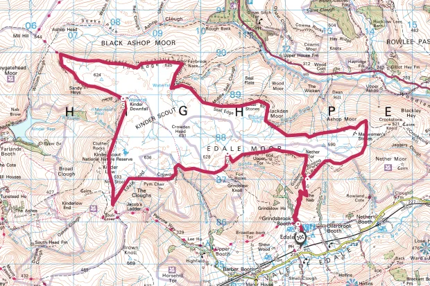
Kinder Scout map
Kinder Scout walking route and map