Tentsmuir is situated at the southern edge of the Tay estuary on Scotland’s east coast, and during the war its extensive sands were at great risk of an invasive landing. Defending its beaches was crucial, and lines of concrete anti-tank blocks, observation towers and pillboxes, all designed to slow down enemy movement inland, were constructed in the surrounding forests.
Nowadays the woods are a tranquil haven of Scots and Corsican pines, home to roe deer and red squirrel.
During the war, the adjacent former RAF Leuchars was the second most northerly air base in the United Kingdom, and just north of Leuchars the access road to Tentsmuir Forest passes the remains of a camp where Polish soldiers lived. These hardy fighters worked tirelessly with locals to build the defences that stretched along the coast for some six miles.

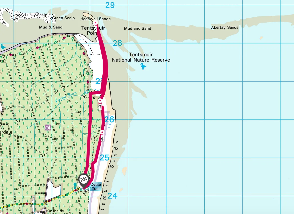
Tentsmuir walk
5.7 miles | 3.5 hours | moderate
1. to the sea
To discover their labours for yourself, follow the Seashell Trail waymarkers from the car park along the edge of the forest. You will reach a concrete observation tower on brick legs, close to the path. Archaeologists believe this formed part of the Tentsmuir defences, put in place at the time of greatest danger between 1940-42 to watch for a seaborne attack and to alert RAF Leuchars of approaching danger.
Walk on to arrive at a stone hut, actually an icehouse used to store salmon and dating from the 19th century. Follow the trail towards the sea and Tentsmuir Point.
2. Building blocks
You’ll reach the shoreline sites that featured anti-tank traps: lines of concrete blocks large and small. Many of these sturdy blocks have been moved to other parts of the sands where they serve as sea defences. By the same stretch of shore, at low tide, you may spot long, wooden upright poles. These were put in place to make life difficult for enemy gliders intent on landing behind defence lines. Saunter back to join the return leg of the delightful Seashell Trail.
3. On the tracks
A narrow gauge railway track was discovered in the dunes here in 2010 after being covered up for decades. Probably used in the construction of the defence system, it is visible after very high tides and storms. Its dramatic appearance highlights the changing nature of Tentsmuir. The sand holds other secrets, too – beer bottles discarded by the Polish soldiers have been unearthed here.
4. A peaceful end
Divert right at a junction to find a pillbox, which would have held heavy guns trained over the North Sea. Those days must have been extremely tense but thankfully the weapons were never fired in anger. Something to ponder as you follow the trail back to the start.
Tentsmuir map
Tentsmuir walking route and map