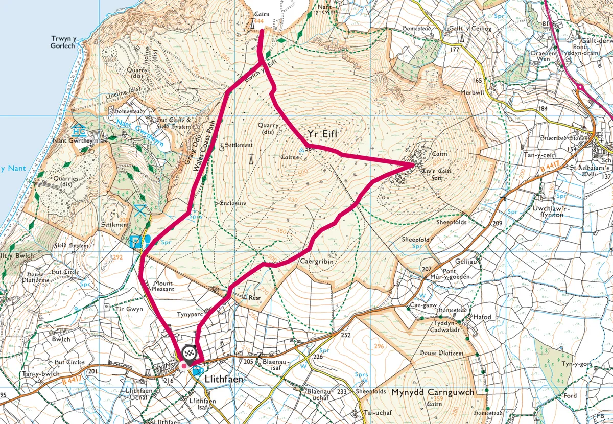
Mountainous in spirit if not in height, Yr Eifl is a hill of vertiginous vistas and igneous granite intrusions. Its craggy summits have various names but are referred to here as Garn For, Garn Ganol, and Tre’r Ceiri, and this walk scales all three.
The first two peaks are a bit of a scramble – for an alternative, lower route, a valley path skirts the valley to the north and east of the mountains.

Yr Eifl walk
4.5 miles | 3 hours | challenging
1. Island views
Bus passengers from Pwllheli can alight at Llithfaen and walk to the car park along a quiet road with silvery views to the Tudwal Islands over the Llyn Peninsula’s soft hills.
2. Heathland
From the car park, take the Wales Coast Path to Bwlch. The scratchy heath brushes at your ankles, the pastel-coloured scrub scarred with streaks of matt-grey granite.
3. Forest to king
Far, far below a glossy stand of pines, fringed by a charcoal-grey beach, sea-smashed and seal-haunted, is the old quarrymens’ village, now a Welsh Language Centre – Nant Gwrtheyrn, or Vortigern’s Stream. Little is known about Vortigern, the British king blamed for facilitating the Saxon invasion, but according to legend he fled to North Wales and died here in this creek, overlooked by the towering black cliffs.
4. Mountain mist
The brackeny hills behind flash red through the mist, and racing clouds chase purple shadows across a brilliant sea. From Bwlch, the magnificent Eryri (Snowdonia) mountains soar high in the east like a mighty ocean of blue waves above a valley of mist.

5. Scrambling forth
On the left, accentuated by a telecoms tower, is Garn For. A slithery scramble gets you up close to the granite that paved the streets of Liverpool and Manchester and was hewn into Olympic curling stones. Below, miniature waves crimp the coast, and Anglesey lies offshore beyond the glimmering Menai Strait.
For those keen to avoid the scramble, drop down towards the village of Llanaelhaearn, before rejoining the upland route at Tre’r Ceiri.
6. Blustery summit
From the track, take the marked path straight up Garn Ganol. A brisk wind whips the summit and bryophytes lurk in the many crevices underfoot. Extending west, the broad Llyn Peninsula and both its coasts fizz in a golden light. East, the Snowdonia mountains are clear and bold, blue-brown and framed by granite, a drystone wall drawn across them as if by biro. From here you can see the prehistoric hill fort of Tre’r Ceiri, which was still inhabited by Celtic Britons during the Roman occupation.
7. Iron Age defence
Reach Tre’r Ceiri by descending Garn Ganol to follow the waymarked path across boggy ground. Cloud descends quickly here. Vaporous tendrils creep around the dark stones of the defensive walls. Within them are the circular remains of 150 huts, abandoned by the inhabitants of Tre’r Ceiri as the climate cooled and crops became increasingly harder to grow. Vortigern, if he came here, would have found Tre’r Ceiri already abandoned and veiled in a thick, fugitive mist.
8. Scree to pasture
From Tre’r Ceiri, the path to Llithfaen shines like a silver ribbon between a pair of craggy mounds. Descending, the scree gives way to pasture and the cloud gradually lifts. At the road, turn right for the car park or continue to Llithfaen, the village glowing gold against its backdrop of rippled hills.
Yr Eifl map