Amid the lumps, bumps and rounded humps that form the ridgelines of the Brecon Beacons, sits Cribyn.
It’s the kind of peak a child may draw; pyramidal and stacked with brawn. Yet in spite of its mountain status, its summit is neither as high nor as insurmountable as you may imagine.
The Brecon Beacons comprises an Old Red Sandstone ridge formed over 400 million years ago during the Devonian period. In the millennia that followed, glacial erosion shaped the landscape that we see today, of steep escarpments to the north and east, banked at their bases with heaps of grey moraine.

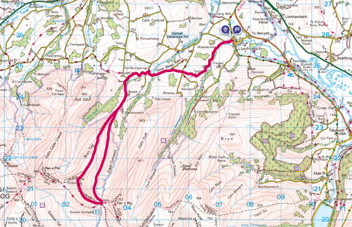
Cribyn walk
18.5km/11.5miles | 6 hours | moderate/hard
Cribyn, at 795m, sits 101m below the tallest peak in southern Britain, Pen y Fan. But far from inferior, the angular mount affords spectacular views over the surrounding countryside, making it well worth the climb.
1. From Llanfrynach
To avoid the crowds, park at Llanfrynach and follow the Three Rivers Ride route to the base of Bryn Teg, a ridge that leads up to Cribyn. The way is steady going, with a short section requiring a half-scramble. The tactility of the rock beneath your hands brings you closer to the land and offers the sense that you are not just summiting some humble hill, but a true mountain.
2. Southbound
Jut after Neuadd, the road swings to the left beside a sign post for the Three Rivers Ride â leave the way marked trail and stay on the road. crossing over a bridge and continuing on for another mile or so.
3. Ridgeback
Continue straight on to leave the roadway and begin your climb up the Bryn Teg ridge. The way is steady going, with a short section requiring a half-scramble. The tactility of the rock beneath your hands brings you closer to the land and offers the sense that you are not just summiting some humble hill, but a true mountain.

4. Summit
From the peak, the impressive rock face of Pen y Fan glows green with mosses and plants, while trailing off to the east is Fan y Big. Look for peregrine falcons, buzzards and red kites swooping gracefully above the national parkâs monoliths. The Black Mountains mark the eastern skyline, while to the south, on a clear day, you can gaze across the Bristol Channel to Exmoor and Devonâs rugged north coast. Drop gently from the peak to the east to meet âThe Gap Roadâ.
5. To the pub
Drop gently from the peak to the east to meet ‘The Gap Road’. This clear track is popular among bikers and hikers, and leads down to rejoin the Three Rivers Ride. As you descend north to The White Swan Inn in Llanfrynach for a well-deserved drink, look back and marvel at your day’s muse: beautiful Cribyn.
Cribyn map