For me and for countless others, the Isle of Skye has an attraction that is distinct from anywhere else. It’s hard to put a finger on what exactly makes the land off the north-west coast of Scotland so special. But for those in search of epic views, there’s no question that this island’s astounding, albeit sometimes foreboding, mountain ranges are mecca.
The largest of the Inner Hebrides has three geological faces. Mountaineers are drawn to its wildly serrated Cuillin Hills, the deeply eroded remnants of large volcanoes. Further south, the 2,800 million-year-old Lewisian gneisses on the Sleat Peninsula are among the oldest rocks in Europe.
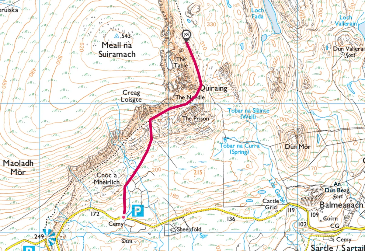
A two-mile, moderate hike to the peak of the unique and breathtakingly dramatic Quiraing on the Isle of Skye in Scotland.
And the north of the island, where we are headed, is composed mainly of lava flows. Glaciers played their part too, sculpting the mountains and the Trotternish Escarpment where the Quiraing lies.

If you are travelling from the south of the island and have passed through Broadford, you’ll get glimpses of some of the Black Cuillin summits from Loch Ainort before rounding below conical Glamaig. Then, on the road to Staffin, there are views of the island of Raasay. At a high point on the road, there’s a sudden view of the Trotternish Escarpment and the unmistakeable Old Man of Storr poking at the sky like an evil stake.
Related articles
1. Labyrinth landscape
A mile-long path leads up to this bizarre feature from the main road. The Old Man of Storr is kept company by other rock spires, collectively called the Sanctuary. These pinnacles and their brothers on the Quiraing were formed as the result of landslips that occurred on the 19-mile long escarpment. Gravity caused the immense weight of the upper volcanic layers of the Trotternish ridge to dislodge the weaker underlying sedimentary rock layers.
Once the post-glacial landslips occurred, the rocks were subjected to erosion, leaving behind the most resistant parts. Now the entire escarpment can be walked as part of a very long outing, but most walkers might find it easier to explore the broad ridge on a shorter ramble.

2. The folded hills
The signed road to the Quiraing begins after Staffin, at Brogaig. With hairpin bends and gradients of 15 degrees, it climbs west up towards the escarpment but is not always passable in winter conditions. After a cemetery, you’ll reach the car park from where you can cross to the opposite side of the road to take the Flodigarry path.
An information board details how the Anglicised Gaelic name Quiraing is derived from the Old Norse Kvi Rand, which means something folded.
It’s an apt description for this, the largest mass movement slide in Britain; in total it extends for more than three square miles and is still active. Every year the coastal road below at Flodigarry has to be repaired due to destruction caused by the landslips.
As you walk north, the ground starts to drop more steeply on the right but the narrow, mainly level path is good. An advantage of going at this time of year – weather permitting – is that there’s a good chance you will have the approach to the Quiraing more or less to yourself, unlike in the warmer months. Enjoy the initial views of the towers and spires that make up the 1.25-mile-wide rock feature.
Be sure to look back, too, as you can see all the way to the southern end of the Trotternish ridge.
3. Island spotting
Soon you will come to a burn crossing, one of two slightly awkward gully crossings. And as you walk on, there is a palpable sense that you are drawing closer to something mysterious. Away to your right there is a marvellous view down to and over the sea where you can pick out Rona, Raasay, and other islands that lie between Skye and the peninsula of Applecross over on the Scottish mainland.
4. Go to jail
After half a mile, the path steepens as it ascends between the outlying rock formation known as the Prison, to your right, and the entrance to the Quiraing on your left.
If you’ve got plenty of time, you can amble around the stunning features of the Quiraing or just head directly for the delights of the aptly-named Table.
To get there requires tackling some steep but short rocky and earthy slopes, but it’s worth it. First you need to reach the Needle – a towering, 20-foot-high shard of dark basalt that stands guard patiently by the Quiraing.

5. Among stone spires
Leave the main path at its crest, marked by a cairn, and climb the steep muddy slope to reach the Needle. You will find yourself in a land of surreal pinnacles and buttresses; there is definitely a hint of the supernatural about this lonely place. Keep to the left of the Needle to continue climbing. Soon a narrow path leads right, up to a gap via a gully.
Take your time and enjoy the surroundings. Between gaps in the rock there are fabulous views to the north and east. You will be able to spot tiny Staffin Island down below and the deep sea lochs of Torridon and Gairloch cutting into the mainland.
6. Lay on the table
A path beyond the gully drops a little before zig-zagging up another steep rise towards a big flat buttress – the Table. The best and safest way to access its flat top is by passing below the Table to the left and then following an easy path up the back of this remarkable little plateau.
On a clear day, the views from here are magnificent, and are enhanced by the magical setting. Covered in short grass, the Table has slipped as a complete section from above and is so level, local folkslore has it that shinty (a Scottish game similar to hockey) matches were once played on its grassy surface. Now it’s the perfect place to stop for lunch.
The descent to the Quiraing, which should be done slowly and surely, follows the exact same route as the one up, although anyone who can’t be dragged away from the wild beauty of the Quiraing just yet can simply stay on the main level Flodigarry path for a further half mile to reach a large cairn and new views out to the churning sea.
Quiraing walking map