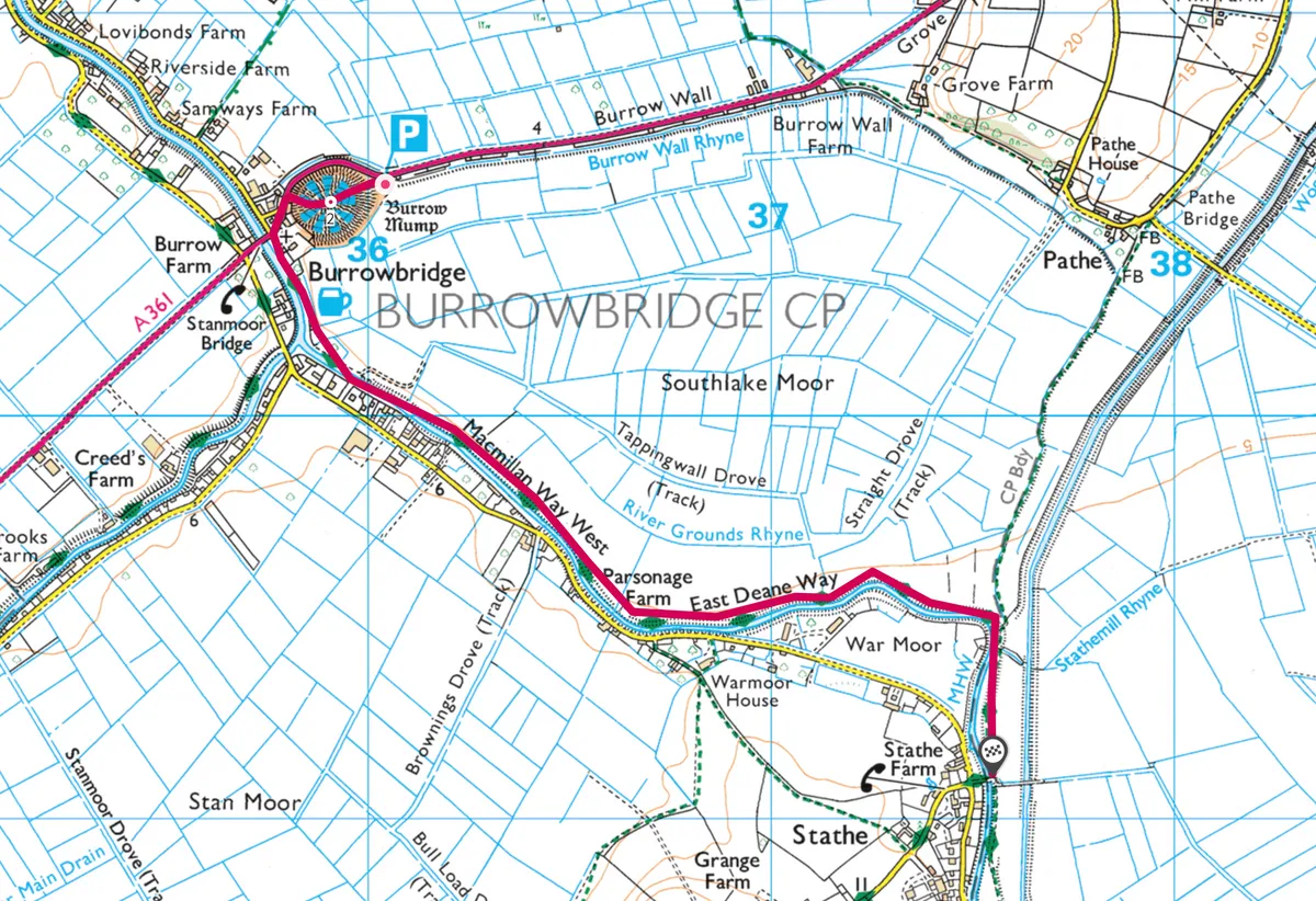
A 6km (4-mile) hike to the summit of Burrow Mump and along the River Parrett to Stathe in Somerset.
Centuries ago, Alfred the Great climbed Burrow Mump to scan the landscape below for marauding Danes. During his reign as the King of Wessex, the Somerset Levels were a vast, marshy sea and this natural knoll was an isolated island and ideal lookout post.
Today, when winter floods mean all around is awash with water, the scenes from above are evocative of Alfred’s day.

1. ‘Hill hill’
At 24m (79ft) tall, it’s a quick clamber up Burrow Mump (both words mean ‘hill’). You can walk up the rippled slopes from the car park or there’s a small flight of stone steps leading from the main road. Approaching from this direction, the shield-shaped gate, with sword inset, hints at the hill’s military history.
The medieval St Michael’s church, now lying in ruins at the top, was used as a refuge by Royalist soldiers during the Civil War. Soon after, the king’s army occupied it again during the Monmouth Rebellion of 1685.
Related articles
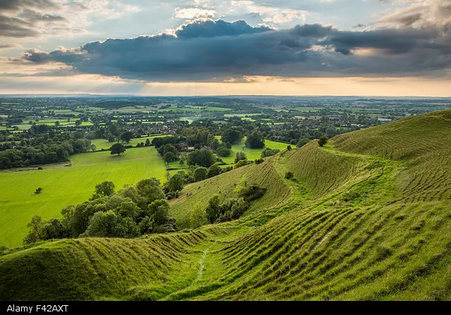
It may not be high, but the views from the Mump’s summit are spectacularly far-reaching. You can see other ‘islands’ among the Levels, such as Glastonbury Tor and Alfred’s own royal isle of Athelney. The rivers Parrett and Tone, often full to the brim at this time of year, mingle at the foot of the Mump and flow away together to the Bristol Channel.
This area was first drained in the Middle Ages by the monks of local abbeys to provide summer pasture. Now, it’s crisscrossed by ditches called ‘rhynes’ or ‘rhines’ lined by pollarded willows.
2. Crossing the river
Back at the bottom of the Mump, a stone bridge spans the Parrett close to where a wooden crossing, built by Alfred, would have once stood. From here, a path passes to the right of the village inn (the King Alfred, of course) and joins the River Parrett Trail.

If flooding allows (be careful – it can be deep in places), walk along the raised bank, between Aller and Stan moors, until you reach Black Bridge at Stathe. The wet meadows provide the perfect habitat for a wealth of wildfowl and waders. Herons fishing for eels are a quintessential sight, but look out also for cranes, which have been returned to the levels after an absence of 400 years. Their trumpeting calls carry for miles across the moors and are both an echo of an earlier era and the herald of a bright new future.
Turn around and head back to the pub for a winter warmer, with Burrow Mump rising before you, floating above the mist-covered moors.
Map
Click on the map below for an interactive version of the route.
Useful Information
HOW TO GET THERE
Burrow Mump, in the village of Burrowbridge, is roughly halfway between Taunton and Glastonbury on the A361. The free National Trust car park is at the foot of the hill.
The Number 29 First Bus service from Taunton to Wells stops at Burrowbridge.
FIND OUT MORE
01934 750833
EAT
Bowdens Farm, Hambridge TA10 0BP 01458 250875 A family run smokery with an award-winning restaurant.
Their beech and applewood smoked eel is a must-try.
STAY
Stathe Road, Burrowbridge TA7 0RY
07866 315992
Homely B&B with views over the Levels and Mump.

