Dundrum Bay is a nature lover’s haven in the colder months of the year when the Inner Bay teems with overwintering birds. This coastal walk begins on the edge of the Inner Bay at Dundrum, one of the county’s loveliest villages, set below a magnificent Norman castle ruin.

Dundrum Bay walk
6.2 miles/10km | 3 hours | easy
1. Quay to crossing
Start out from The Quay, pausing to take in the impressive roll call of winter waders – oystercatchers, curlews, dunlins, knots, turnstones, redshanks and godwits among the gathering. Drink in the views of the tranquil waters and sands with the granite Mountains of Mourne tinged blue in the distance. Now follow The Quay’s promenade towards Main Street. Turn left, taking the grassy path signposted for Keel Point. It follows the shore before joining the drive leading to Murlough House.
Turn left again on to Keel Point driveway and continue to Downshire Bridge. The original wooden structure was built by the Marquis of Downshire to provide access to his summer residence; in 1802 it was replaced by the three-arched stone crossing you see today. Look for elegant mute swans on the water below.
")
2. Wild wonders
Drop down to the shore on the other side of the bridge. At low tide the bay all but empties of water, allowing winter migrants to feed off the shellfish-rich inlet, home to cockles, mussels, clams, crabs and urchins. Look out for pale-bellied brent geese and ringed plovers.
Beyond the old boathouse a signpost points inland. Follow the path through shrubby woodland to Murlough House. The former stables belong to the National Trust while the leased house serves as a retreat centre. Head up Murlough House driveway for a short distance then join the boardwalk on the left that doubles back at an angle to the Outer Bay.
3. Sea and mountains
Turn right at the beach and settle down with a hot drink from your flask, enjoying the open views of the Irish Sea and Mournes. Warmed up, continue along the shore to a post indicating a second boardwalk. It heads inland again through Murlough National Nature Reserve’s fragile 6,000-year-old sand dune system of protected wildlife habitats.
4. Inner bay beauty
Before you reach the car park, fork right where two boardwalks meet, then continue along the gravel track towards Dundrum again, skirting the Inner Bay. This is a section not to hurry: snowy-white little egrets contrast with dark mudflats, beady-eyed herons fish on the shore, while lapwings feed on grasslands. The lane returns you to Downshire Bridge and Keel Point Road.
5. Castle vista
Finish off with a climb up Castle Hill to Dundrum Castle, a ruined medieval fortress built by Anglo-Norman knight and Ulster invader, John de Courcy. Climb steps to a vantage point where you can retrace your walk laid out below in miniature. After the long tramp and bracing winter air, head to the Buck’s Head Inn for a hearty meal, or to Mourne Seafood Bar for freshly caught shellfish from Strangford and Lecale.
Dundrum Bay map
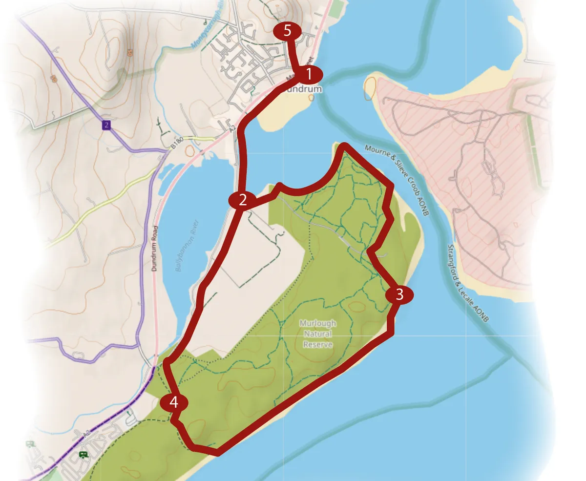
Map credit: OpenStreetMap