This walk can involve some impressive stepping stones to cross the River Derwent. If you do not wish to use them or they are flooded there is an alternative start on the other side of the river at Leadmill bridge just outside Hathersage.
In order to account for the two starting points we will start the walk at the four arm finger post (GR 216 813) on the river bank near the stepping stones.
It is a medium-distance walk with several ascents and 1.2km is on very quiet tarmac track. The route starting at the Leadmill bridge is slightly shorter by 0.5km.

The views across the Derwent valley from the route are truly magnificent and illustrate better than words the magnificence of the Gritstone Edges of the Dark Peak; including Bamford, Stanage, Millstone and Froggatt. There are also views of Losehill, Kinder Scout, Win Hill and Higger Tor. A panoramic view of Hathersage is thrown in for good measure. This is a lot of scenery for moderate effort (220m of ascent).
Parking at Hathersage
- If using the stepping stones to cross the river use the official lay-by on A6187 (Hope Rd), near Jaggers Lane 600m from the stone railway bridge in Hathersage (GR 220 818).
- If not using the stepping stones there is parking is in a lay-by at the Leadmill bridge (B6001) 800m outside Hathersage near the Plough Inn (GR 233 805).
Hathersage and High Low walk
5 miles/8km | 3 hours | moderate
1. The Stepping Stones to Highlow Hall
Option 1: Using the Stepping Stones from the lay-by on A 6187
Cross the road from the layby to the footpath on the opposite side of road, turning right to Hathersage for 150m, crossing back across the road to a finger post opposite (GR 222 815). From the finger post walk diagonally right to the river through fields to the stepping stones across the River Derwent (400m). Cross river using stepping stones to the finger post with 4 arms (GR 216 813).
Stepping stones
The stepping stones, below Offerton, are believed to possibly be part of a coffin route from Abney Moor & Highlow to Hathersage.
Option 2: Not using the Stepping Stones - starting at Leadmill Bridge (B6001)
Cross the bridge (B6001) to the finger post on the right signposted Shatton (GR 233 805). From the wall go through the wooden gate and follow the path through grazed pasture land with the river on the right. After 125m the path forks at a derelict building: this is the point you will return to at the end of the walk. Keep right and follow the tranquil often tree lined path alongside the river for 1.6km until the 4 arm finger post (GR 216 813) is reached: the stepping stones are in the river to the right.
Continuation of the walk
From the 4 arm finger post walk away from the river to go through a single gate (20m), and then ascend, on what was likely to be a Drovers route, through grazing fields for 500m, through several gates to reach a tarmac track at a field gate (GR 214 811). Turn left on the tarmac track up-hill through the hamlet of Offerton.
Offerton Hall
Offerton Hall (GR 212 810); 1658 Grade II listed.It was originally built in the reign of Henry IV (1367 – 1413), by Nicholas Eyre, of Highlow Hall for one of his sons. The walk passes another two of the substantial halls (Highlow and Hazleford) built by the Eyre family in the Hope valley. The family dominated this part of the Peak District, being in their ascendancy until the 16th century and still with substantial land ownership into the 18th century.

Continue on the tarmac track for 150m, ignoring two finger posts on the right as the track turns left uphill which becomes level with Offerton Hall on the left. The wooden stile on the left (GR 815 808) is where the walk returns to. Shortly after the wooden stile in the field is a single stone pillar on the right (GR 217 806) called Robin Hood’s Stoop. This is an old boundary stone which was perhaps originally part of a medieval wayside cross.
Robin Hood’s stoop
Robin Hood’s stoop reputedly marks the spot where Robin Hood fired an arrow over to St Michael’s church, Hathersage, 2 km across the valley. The magnificent views across the valley, with the gritstone edges on view and Hathersage village below you, are truly breath taking. Starting from left to right is;
- Win Hill
- Ladybower reservoir; just out of sight
- Howden moor
- Bamford Edge
- Stanage Edge; opposite where you are standing
- Higger Tor
- Carl Wark
- Millstone Edge
After a further 900m on the track, after going down past Callow House farm and then uphill, the tarmac track meets a road junction opposite Highlow Hall.
Highlow Hall
Highlow Hall is Grade II* listed and dates from the 16C but the original house dates from the 14C. It passed by marriage into the Eyre family when Nicholas Eyre married the younger of the two Archer sisters. It is said to be haunted by the ghost of the older sister who had been expected to marry Nicholas but killed herself when Nicholas married the younger sister instead.
Nicholas' eldest son, Robert, built a hall for each of his own seven sons - the Halls of Moorseats, Shatton, Nether Shatton, Hazelford, Offerton, Crook Hill and North Lees - all within sight of Highlow Hall and contacted by a signalling system to alert the sons when their presence was needed.

2. Highlow Hall to Hazleford Hall
With Highlow Hall in front of you turn right on the road, then left (75m) through the gate at a finger post (GR 218 801), then downhill (300m) through the field with Highlow Hall on the left.
At the edge of the trees continue downhill through the gate and wooded area to a stream (Highlow Brook). Cross the first foot bridge then turn immediately left though the trees (GR 220 796). DO NOT cross the second foot bridge to the right.
Walk through the wooded area, open fields (900m) and several field gates, following the footpath signs, until Torr Farm is reached. With the farm on the left the tarmac track soon reaches a minor road, on a bend.
Turn right uphill for 150m until the road turns sharp right with a grassy area on the left, which is a good place for lunch, and a finger post public footpath pointing downhill through a gap in the stone wall; this is where the walk continues. Follow the finger post downhill 90m to the wooden stile at a tarmac road and on your right is another Eyre family residence: Hazleford Hall.

3. Hazleford Hall to the Stepping Stones via Offerton Hall OR Leadmill Bridge
Turn left at Hazleford Hall on the tarmac road. The road appears to fork left (75m) but keep right on a private drive with a finger post and turn right downhill on a tarmac drive with a stone engraved Hog Hall in the wall on left as you walk downhill. After 100m take the wooden kissing gate to the left of the entrance to Hogg Hall (GR 230 800).
Follow the path downhill, with Hogg Hall on the right, through the field, over a stone bridge (crossing Highlow Brook) and then a small gate, continuing uphill (75m) to a tarmac track and a wooden telegraph style pole.
Cross the track and follow the path left uphill, traversing the slope (GR 228 803) towards some buildings and trees, then right uphill into the field, via finger posts, until you see a wooden gate in the wall / hedge on the left (150m) ahead.
Turn right through the gate and follow the path downhill (50m) to the road, turn left and after 10m take the tarmac drive on the right at a finger post for a Public Footpath (GR 227 804). Follow the tarmac track downhill (100m) until Mount Pleasant farm driveway is reached.
Return to the Stepping Stones: see directions after the Leadmill bridge directions:
Return to Leadmill Bridge
With Mount Pleasant drive on the left don’t continue on the track but take the path through the wooden gate on the R (GR 226 805), next to a metal field gate. From the gate the wide grassy path crosses the field downhill (100m) heading towards some mature trees with a stone wall beneath them. Keep the trees and the stone wall on the L continuing through the field.
The path goes downhill to meet a wooden gate (400m) with a stone stile in the wall (GR 230 805) which you cross going down the steps in the embankment to the pasture below at a finger post. At the foot of the steps turn right on a grassy path, keeping a derelict storage building on your left, and return to Leadmill Bridge and the start of your walk.
Return to the Stepping Stones
With Mount Pleasant drive on the left take the stony track downhill and after the track swings right (150m) it becomes level, before reaching Broadhay Farm. At the finger post and field gate on the left, go through the gate.
Walk L through the field on the grassy path, at the bottom of the slope, with the trees high up on the R, until a field gate is reached (100m). Go through the gate, over a stream, and follow the path through Callow Wood which traverses the slope right uphill to a gate in the wall (600m). This is Callow House Farm.
Walk up through the field to the next gate, across the farm track, keeping left, and then though the gate on the right. Follow the path (300m) which traverses the hill sidepassing through a gate, and over a stream until it reaches a stile in the fence at a tarmac track (GR 815 808). Turn right on the tarmac track used earlier in the walk and walk back to the 4 arm finger post next to the River Derwent and the Stepping Stones via Offerton Hall.
4. Offerton Hall to the Stepping Stones / Shatton
From Offerton Hall return to the start by repeating the route taken earlier in the walk to the 4 arm finger post at the Stepping Stones.
If you started at the Stepping Stones cross them and return to the start of the walk in the lay-by.
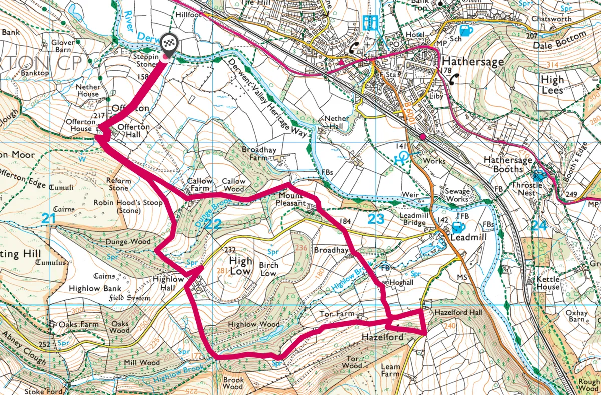
Hathersage and High Low map
Hathersage and High Low walking route and map
We are a Sheffield family and with James, and his brothers, spent many days walking in the Dark Peak's valleys. The walks in this book are a mix of high and low level, short and long and include five linear walks where the start and finish can be completed by the local stopping train. The five walks are 6-8 miles each and make up the original James Brownhill Challenge (JBC) walk which was 22 3/4 miles long; a mile for each year of his life.
There are a further 13 round walks and each walk is referenced to the other walks, where they are met, to allow readers to build their own walks.
There are is background information on the local history and geology of the valleys and the Dark Peak, with a separate piece about the social and industrial history of Stanage Edge.
It is spiral bound to allow it to be taken on walks, it includes maps and lots of grid references. There are points of interest on each walk to help put the location in context of it's place in history.
The profits from book sales will go to the James Brownhill Memorial Fund (www.JBMF.co.uk), which provides bursaries each year to pay for University volunteer climbing club leaders to attend training course for leading winter mountain climbing trips.


