The immense slotted stone base of a venerable way-post stands at a junction of rough, wide, walled tracks on breezy Mellor Moor.
Its fissured wooden stump has empty fingerplate sockets seeking past destinations – old roads to nowhere.

It persists amid umpteen tracks, drovers’ roads, saltways and pre-turnpike roadways that course across, along and between the moors, ridges and dales forming the western edge of the Peak District as it declines towards the Cheshire Plain. Such byways have emerged over millennia in an area with a particularly rich history, proffering an imprint of these fading eras as an ideal aid for exploration, with glorious deep-country views a pleasing boon.
Old mercia ways Prehistoric trackways remain teasingly unconfirmed, but ghostly routeways of the Dark Ages are more palpable here. A little north of Mellor Moor stand Robin Hood’s Picking Rods – worn, carved marker-stones set upright in a base over 1,000 years old. The line of an ancient trackway has been surmised as passing south from these across Mellor Moor to link with the Bowstones, another brace of enigmatic relict cross shafts above nearby Disley. All are held to be waymarkers along a monks’ or pilgrims’ way between widely separated monasteries in old Mercia.
Related articles
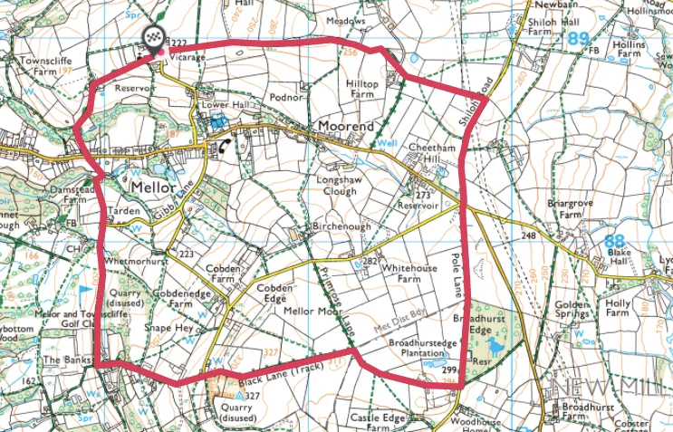
Mellor Moor walk
4.2miles/6.8km | 3 hours | moderate
1. Church and fort
Nearby, the remote and eye-catching Mellor Church – which houses possibly Europe’s oldest wooden pulpit and a Viking era font – commands a ridge that undulates from the looming Dark Peak. It stands on a far older site, evidenced by the encompassing Iron Age hillfort, complete with round hut reconstruction. From here an airy ramble east along the fort’s rampart-line, then south along Shiloh Road and Pole Lane, also incorporates both the elevated pilgrims’ thoroughfare and the de-signed pre-turnpike tracks.
2. Mines and mills
Turn west on to Primrose Lane, then north via Mellor Golf Course back to the start. This area oozes industrial history: drift mines, small flagstone quarries and secluded woollen, bleaching and textile mills hide in plain sight or decay amid the deep vales. Trains of sturdy packhorses carried their products to market along well-worn trails. Their incised, hoof-ground trods interlink the veneer of old ways threading Mellor’s hills and vales and afford an accessible way to time-travel to a tantalisingly close past.
Mellor Moor
Mellor Moor walking route and map