Explore Porthmelgan on this 3.5 mile walk through a lush Pembrokeshire valley home to wild ponies, kestrels and peregrine falcons.
A small valley dotted with signs of ancient habitation runs through the moorland of St David’s Head. The vale ends at Porthmelgan cove, where its stream flows into the rolling sapphire waters of Whitesands Bay.
The cove is carved into soft shale, flanked with harder rock that makes up the protective promontories that form the bay. When the tide is out, the sandy beach invites exploration of rock pools and a cave.

The cove is the perfect place to gaze toward Ramsey Island and the Bishops and Clerks rocks. South Bishop Lighthouse, almost 8km away, seems like a dreamy trick of the eye as it appears to hover above the water on hazy summer days.
Porthmelgan’s seclusion owes to the fact the nearest car park is 1.5km away at Whitesands Beach, where there’s also a café and toilets.
More related content:
Porthmelgan walk
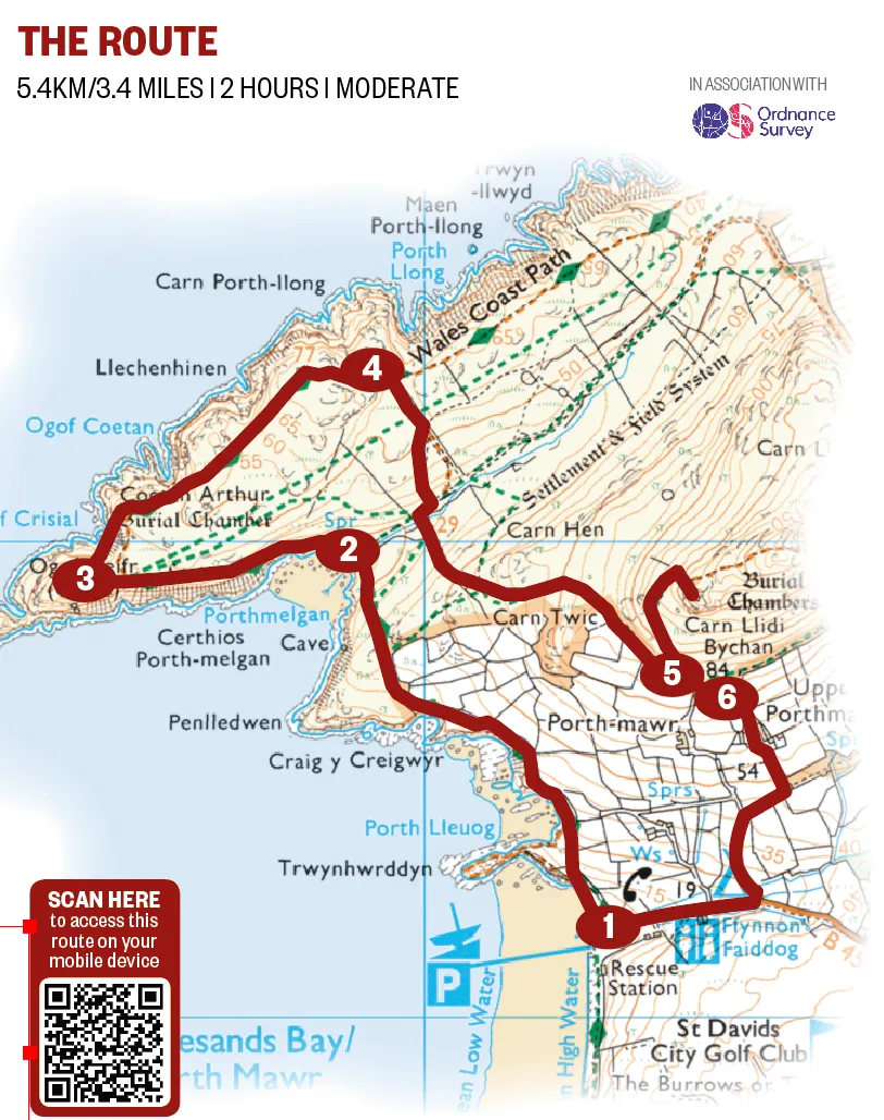
5.4km/3.4 miles | 2 hours | moderate
1. Paradise cove
acing the sea, take the coast path north from Whitesands car park, crossing open-access land where Pembrokeshire ponies roam free. Follow the main path as it drops into the valley. Porthmelgan is to the left.
2. Beyond the wall
After exploring the beach, rejoin the path and follow it to St David’s Head. Pass through a gap in an Iron Age wall – which once stood at a height of 4.5m – beyond which lies the distinct markings of round huts.

3. Coastal raptors
Return through the wall to the main path and turn left, continuing along the coast until you reach a rocky mound on the right. The distinctive rock formation of Coetan Arthur, which dates from about 3,500 BC, sits atop the hill and is thought to be the collapsed entrance of a burial chamber.
Follow the coast path north-east through a largely unaltered Iron Age landscape. Look for kestrels perched on the massive boulders that dot the landscape, or peregrine falcons in flight.
4. Coconut perfume
At a signpost, turn right and descend gradually for about 400m into the valley. Stick to the main path as it moves uphill between gorse, with its sweet, summertime coconut aroma.

5. Island view
Round Carn Llidi and, keeping a stone wall on the right, look for a distinct track leading uphill on the left. Follow this to the peak, where you can see the footings of a radar station from the Second World War. On a clear day, Skomer Island can be seen across St Brides Bay to the south. Return to the main path by the same route.
6. Bay return
Turn left on to the main path then, shortly after, take a right. Follow the footpath signs to the road and take a right back to the car park.
Porthmelgan map
Porthmelgan walking route and map