To wander through a bluebell wood in spring must rank as one of the highlights of nature’s calendar. Vast swathes of these intensely blue flowers carpet the landscape in late April and early May, bringing a true sense of enchantment to our native woodlands, fields and hedgerows.
Bluebells, or Hyacinthoides non-scripta, are a fabulous indicator species, generally denoting an ancient woodland. Their appearance marks a turning point, the final flourish of the forest floor before the leaves of the canopy unfurl and reduce the available light reaching the ground.

Bluebells in Yorkshire
One of the best places to see bluebells in the UK is Yorkshire’s Newton Wood, an arboreal blanket cloaking the lower slopes beneath Great Ayton Moor. In the care of the National Trust, this mature, broadleaved forest – home to sessile oak, rowan, ash and alder – is a great place for kids and dogs to explore. A chorus of birdsong echoes through the woods as migrant warblers, such as chiffchaff, blackcap and willow warbler, set up home, while cuckoos, noisily announcing their arrival from Africa, can be heard calling from the woodland edge.
The purple haze and delicate scent of bluebells spreads through the understory of this 400-year-old forest, joined by the distinctive aroma of wild garlic. And dotted throughout are the small white flowers of greater stitchwort, wood sorrel and wood anemone.
Yorkshire’s Matterhorn
Towering above Newton Wood is Roseberry Topping. Yorkshire’s Matterhorn, as it is also known, sits in the far north-west of the North York Moors National Park. It’s thought that its iconic profile may have been caused by a mine collapse in 1912. The soft clays and shales that lie beneath Roseberry Topping’s hard sandstone cap are rich in alum, jet and ironstone – it was this underlayer that the Victorians tunnelled into.
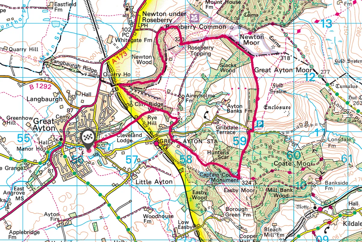
Roseberry Topping walking route
7.8 miles | 5 hours | moderate-challenging
1. Into the trees
Start from the village green in Great Ayton, heading east along High Street before turning left on to Newton Road. Take a gate on the right and follow the footpath past Cleveland Lodge. Take care crossing the railway line and follow the footpath up the side of the field to reach Cliff Ridge Wood where you will encounter your first hint of the bluebell spectacular to come.
2. Captain Cook’s farm
Some steps lead up to the main footpath, which then climbs to a kissing gate. Turn right along the edge of a field to a stile, and then drop down to another stile to join Aireyholme Lane. Just up the lane is Aireyholme Farm where Captain James Cook worked as a boy with his father.

3. Overgrown remains
Turn right to follow Aireyholme Lane to the junction with Dikes Lane and head straight over at the crossroads. Continue straight ahead on the bridleway that climbs up the hill. On the south side of the bridleway lie the overgrown remains of the once-extensive Ayton ironstone mines that ceased working in 1928.
4. Woods and moor
At a path junction, turn left on the footpath, climbing uphill through Ayton Banks Wood on to Easby Moor. Follow the path round to the right, heading directly for Captain Cook’s Monument. This sandstone structure was erected in 1827 in memory of the celebrated explorer. The location also offers spectacular views of the Vale of York and the Cleveland Hills.

From the monument, follow the Cleveland Way – one of the UK’s great long- distance footpaths – as it heads north across Easby Moor and Little Ayton Moor to join a forest track. Follow the way over Cockshaw Hill to the car park at Gribdale.
5. Roseberry vista
Go straight over the road and continue on the path across Great Ayton Moor. The trail swings left over Newton Moor and then turns left again across Roseberry Common, making a beeline on stone slabs for Roseberry Topping. The area was heavily mined in the 18th and early 19th centuries, with surface jet mining to the north of the path and ironstone to the south. Ascend on the stone steps to reach the 320m summit of Roseberry Topping.
6. Swathes of colour
The view from the summit is magnificent, taking in the North York Moors, the Yorkshire Coast, the Pennine hills and industrial Teesside. Spend some time on the hilltop to savour the extensive views, then take the northward path, quickly dropping off Roseberry Topping. Cross open country to reach a trail known as Brant Gate. ‘Gate’ in Yorkshire originates from the Old Norse ‘Gata’, meaning road or path, which suggests the route has been in use for many centuries.

Follow Brant Gate left, heading downhill to meet Roseberry Lane. Take the bridleway south, climbing back through Newton Wood. The path slants steadily up through the trees, forking left before continuing the climb to a path junction and bridle gate. Look north-east through the trees and beyond a stone folly for a beautifully framed profile view of Roseberry Topping.
Beyond this point, huge blankets of bluebells cover the woodland floor. Follow the path along the top of the wood and, at a fork, take the right-hand path to continue downhill. Turn left at the bottom of the hill along the foot of the wood to join a stone track.
7. Railway remains
Turn left on to the track and then left again at a National Trust sign into Cliff Ridge Wood, greeted by more bluebells. The undergrowth hides the remains of a narrow gauge railway that once connected Cliff Rigg Quarry to the main line network down in the valley.
The path makes its way along the bottom edge of Cliff Ridge Wood to the path junction that you first encountered on your outward route (point 2). Turn right and retrace your steps across the railway line and back into Great Ayton.
Map
Roseberry Topping walking route and map