Lying within 10 miles of Newcastle upon Tyne’s city centre, the short stretch of shoreline between Seaton Sluice and Whitley Bay is typical of the Northumberland and Tyne and Wear coast.
Industrial relics, rocky headlands, sandy coves and fossil shales follow each other in quick succession, with an abundance and variety of wildlife wherever you look.
Central to the scene, and a dominant feature from almost all viewpoints, is St Mary’s Island, standing just a few hundred metres offshore. An island only at high tide, it’s easily reached when the waters recede by means of a causeway that leads through an extensive area of rockpools.

Wildlife at St Mary's Island
Though the terns, swifts, swallows and other summer migrants have long departed south, the resident birdlife – including redshanks, curlews, oystercatchers, dunlins and various species of plovers and gulls – is augmented in winter by visitors from Scandinavia and Russia. Many of these are passage migrants, such as redwings, fieldfares and pink-footed geese, glimpsed as they fly inland toward more sheltered farmlands and freshwater ponds.
Others will remain through the cold months, finding a rich harvest of invertebrates in the sands and seaweed-covered rocks. Golden plovers congregate in large flocks, rising en masse for little apparent reason, then settling again. Sanderlings dart back and forth mere inches from the creep of the tide. Colourful snow buntings hop about in close proximity to humans, while whimbrels and bar-tailed godwits maintain their distance at the edge of the rocks.

A viewing area and hide on the seaward side of the lighthouse looks over the outer rocks, where grey seals haul themselves out to rest in the wintry sun. They will have swum here from Lindisfarne and the Farne Islands to the north, where they gave birth to their pups during the autumn.
You may also like:
Harbour porpoises and white-beaked dolphins might also make brief appearances, the latter being more abundant in these North Sea waters than their bottlenose cousins. Wheatears and pied wagtails can be seen skipping across the rocks, and out to sea you might catch sight of passing cormorants, shearwaters, petrels and skuas, or rafts of floating scoters and eiders.

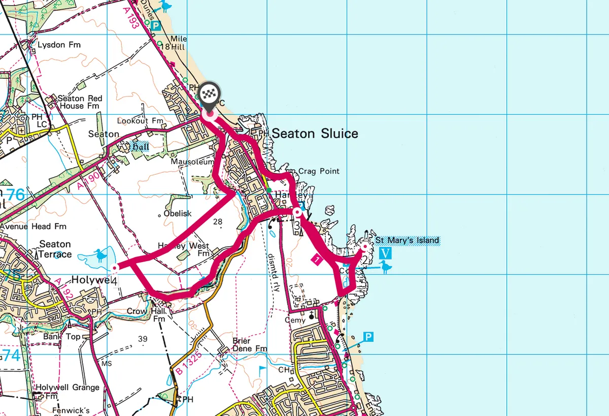
St Mary's Island walk
6.6 miles/10.5km | 4 hours | easy
1. To the lighthouse
From the car park beside the roundabout to the north of Seaton Sluice, follow the footpath to the harbour.
The surrounding low hills are largely composed of chalk, sand and flint, once used as ballast by ships that carried coal to London. An 18th-century glass factory here was once the biggest manufacturer of bottles in England. The harbour mouth suffered from silting, so The Cut – a straight channel to the sea, 270 metres long, nine metres wide and five metres deep – was dug in 1761.

From the footbridge over The Cut, continue south around Collywell Bay. The bay is dominated by a large boulder known as Charlie’s Rock, which was named after a local character who planted a garden on its summit.
Follow the footpath along the cliff edge past Crag Point and on to the car park east of the Delaval Arms. Continue on the cliff-top path around the next bay. Fossils of prehistoric plants can be found in the shale beds beneath this stretch of cliff. If the tide is out, cross the causeway on to St Mary’s Island.

2. Winter wetlands
Return to the mainland and follow the promenade south around the bend to a car park at the northern end of Whitley Sands. A viewing screen allows you to observe the gulls, mallards, moorhens, coots and possibly short-eared owls that frequent the small wetland nature reserve.
From the western end of the car park, take the bridle path northwards – this will bring you back to the Delaval Arms. Across the road is Old Hartley. In 1862, the nearby Hartley colliery was the scene of one of the worst disasters in British mining history, when a blocked shaft led to the deaths of 204 men and boys. Following the tragedy, new legislation was written making it compulsory for all mines to have two separate shafts.

3. Dene and pond
Cross the road to Old Hartley and continue downhill past the remains of a railway bridge. At the bottom of the hill, enter Holywell Dene and take the surfaced road to a bridge over Seaton Burn. Cross the bridge and stile and follow the riverbank through semi-natural woodland with a dense understorey of shrubs and brambles. The path leads past a cataract and several fallen trees that bridge the river.
Where the stream emerges from a constructed tunnel, go uphill to a junction with an old waggonway. Go through the old railway bridge to meet a straight path that runs between hawthorns – there may still be berries on the trees, providing a valuable winter food source for flocks of redwings, fieldfares and possibly even waxwings.

When you reach a second track crossing the footpath, follow this to the left. Look out for waders as you pass a field with a wet scrape. Continue to the next field and an open hide looking over the southern shore of Holywell Pond, where pink-footed geese, flying in over St Mary’s Island, mix with resident greylags. Curlews and redshanks forage at the pond’s edge and a kingfisher can often be seen perching among the nearby reed beds.
4. Northern arrivals
Return past the scrape and continue through open fields, possibly accompanied by flocks of hedgerow birds, such as tits, buntings and finches. Some of these will be residents, but a substantial number will have arrived in the autumn from northern Europe.

To your left stands an 18th-century obelisk, associated with the nearby National Trust property of Seaton Delaval Hall, while about a mile in front of you, rising above the field boundaries, is the lighthouse of St Mary’s Island.
The footpath continues through an avenue of gorse and hawthorns before descending over a stile and along a series of steps into the northern part of Holywell Dene. Turn left and follow the west bank into Seaton Sluice. The final stretches of the burn are tidal and lined by muddy banks that provide good foraging for waders.
Map
St Mary's Island walking route and map