On the Isle of Wight, spring can appear out of the blue: a clear day with warm southerly winds may push the first show-stopping migrants across the Channel. These include thousands of swallows, house martins and sand martins returning from Africa to breed, timing their arrival with the explosion in the population of insects – triggered by the warm weather – on which to feed themselves and their voracious chicks.
One of the very first places to welcome spring arrivals to the UK is the high downs that bunch together in the south-east corner of the Isle of Wight. This is where the chalk spine of downlands that crosses the island finally runs out of steam and collapses into a heap of undulating ridges. Extremely easy on the eye, these fall away precipitously into a series of concentric punchbowl valleys.
You’ll find the greatest drama – and the bulk of the arriving birdlife – up above the bucket-and-spade bustle of the coast, from Ventnor Down and Wroxall Down in the west to Shanklin Down and St Martin’s Down in the east. In the middle lies St Boniface Down, at 241m the highest point on the island, which in turn morphs into Nansen Hill, named after the great Norwegian polar explorer Fridtjof Nansen (even though he never visited the Island).

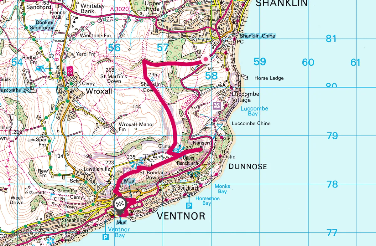
Shanklin to Ventnor walk
4.6 miles/7.3km | 3.5 hours | moderate
1. Holy beginnings
Start at the 12th-century church of St Blasius on the edge of the coastal resort of Shanklin. After admiring the rather spooky lychgate, walk through the grounds and cross over the boundary wall at the back of the church to follow the waymarked Worsley Trail uphill through two fields.
The path enters woods and to your right is Holme Copse, a maturing mix of oak, ash and hazel planted in 2004. At this point, the track is something of a woodland corridor, providing important links to other habitats for dormice and red squirrels. As you emerge from under the canopy, keep ahead and follow footpath SS10 (signposted for Wroxall).

2. Wildflower downs
Go through the gate directly ahead of you and turn sharp left uphill along footpath SS12. The climb soon eases off at a brow where St Martin’s and Shanklin Downs collide. Look out for flowers that often emerge a few weeks earlier here than elsewhere in the UK, including the violet-blue blooms of devil’s-bit scabious and the low-growing salad burnet.
You now head straight on, contouring south-west along the ridgeline, the land falling away to your right and thickets of gorse to your left where swallows are highly likely to flit past your eyeline. The scenery here is simply outstanding.
Let your imagination go and you can almost see the joins where nature has knitted this sweeping landscape together; the ridges of the downs may resemble the arms of inviting sofas while in between them the ground falls away into crumpled, pillow-like geometric sweeps. It’s a spectacle that invites you to ease yourself into the chalk grasslands for a day’s walking.
3. High on the hill
You reach a small car park by an access lane to the transmitter masts on St Boniface Down. Here turn left, with the fences to your right, to make your way on to Nansen Hill. To the north the entire sweep of Sandown Bay is laid out for inspection, all the way to the distant chalk finger of Culver Down, some six miles away. In front, the English Channel spans the horizon.
This part of the route is a ‘there-and-back again’ section; walk down the hill as far as you wish, as if making for the sea, before returning to the ridgeline. Nansen Hill will certainly bite into your calf muscles as it descends (and ascends) 100m in just 300m.
The fluttering migrant, exhausted and famished, that makes landfall on Nansen Hill will find that nature’s kitchen has laid on quite a larder, for the high downs are rich in insect life that thrives on a sympathetic landscape of cattle-grazed downland. Nansen Hill is part of the Ventnor Downs SSSI and, as spring emerges, the chalk grasslands are magnificent for butterflies and orchids. You may spot the Glanville fritillary butterfly (chequered orange and brown) rising up from the landslip areas at the foot of the hill, for the Isle of Wight represents the northern limit of its range. Common spotted orchids can be found on the wave-cut grass ridges, known as terracettes, on the higher north-facing slopes. The bluebell displays are truly spectacular.

4. Grand vista
Back on the top of St Boniface Down, bear left in front of the transmitter mast, walking clockwise around it with the fence on your right. There is a bench in front of the masts where you can sit and take in the view west towards another ensemble of ridges around St Catherine’s and Stenbury Downs. The grazing feral goats you may see form a herd of 30 that were introduced to keep the scrub in check and allow wildflowers to thrive.

5. In Gandhi’s steps
Head downhill, zig-zagging into a huge, funnel-shaped valley in the shadow of the hump-like outline of Ventnor Down. At this point you are following in the footsteps of Mahatma Gandhi, who would go walking with his landlady’s daughter during a stay in Ventnor. The path runs beside a fence, passes through a gate, then descends steeply to emerge by an industrial estate and the former Ventnor railway station. Cross the road and drop down Grove Road, which winds into Ventnor.
Stop off for a cask ale at the cosy Crab and Lobster Tap, for 200 years the only pub in Ventnor. Otherwise, continue downhill on to the esplanade where you will be spoilt for choice for ice cream to enjoy on the beach.
Shanklin to Ventnor map
Shanklin to Ventnor walking route and map