Hanging woodlands drape the hidden gorge of the River Darwen where it cleaves through a sandstone ridge near Blackburn.
A good, often muddy path traces the river past industrial relics, beside foaming torrents and through a revitalised weaving hamlet. A canalside start, a charming village pub and a country park add variety to this beautiful walk.

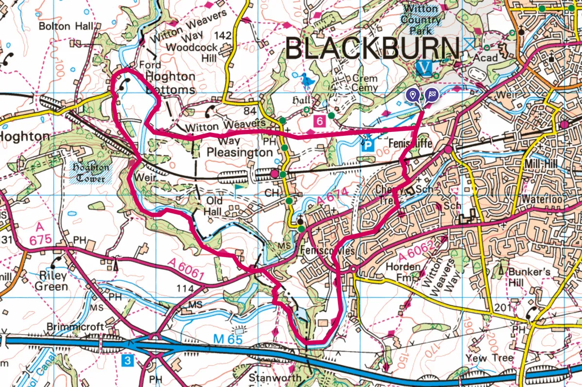
Blackburn to Hoghton Bottoms walk
6.6 miles/10.6km | 3 hours | moderate
1. Park promenade
Join the Weavers’ Wheel tarred cyclepath (spinning wheel icon and red-backed arrow) heading south from Pleasington Playing Fields (Tower Road) car parking. Beyond grass, this rises through oakwoods, levelling before crossing a railway bridge; here turn left along The Crescent, then left again after the right bend. At the main road turn right, then go left on Cherry Tree Lane. Cross the grassy parkland’s right edge to the Leeds and Liverpool Canal.
2. Tread the towpath
Walk the tranquil towpath (water on the left) for 1.2 miles to Bridge 93 (not 93B). Here, descend the waymarked fence-side path through woods, then skirt the right-edge of the demolished cotton mill complex (remain outside the fencing) to reach the main road.
3. Viaduct view
Rise to the left, then join the track beside the top of the terrace opposite. Use the handgate (on the left) 50m before a renovated farmhouse, heading to a hedgerow handgate left of the buildings. Turn left to a third handgate, then half-right to a fourth into woodland. Bear left, steeply down (stepping over three becks) to meadows beside the River Darwen.
A clear path heads downstream to enter the wooded gorge, known for its range of birds and strong autumnal colours. The path is eroded and thin in places. Beyond the horseshoe weir, progress below the 35-metre-tall railway viaduct.
4. Halfway hamlet
From the nearby terrace, walk tarred Viaduct Lane to a T-junction in 550m. Turn right down through Hoghton Bottoms hamlet. Cross the lane-end green iron footbridge (left) over the Darwen. In a dozen paces, turn right along the waymarked wide path.
In 400m use the gate-side handgate, right, and stroll upstream via a stile/handgate to approach a stone wall (the golf course boundary). Head left, change wall-side at the stile and follow the path at the foot of the woods. This well-marked way continues beside pastures and crests a modest, tree-topped hill.
Advance along the grassy ridge to reach a cul-de-sac at the edge of Pleasington, then the Butlers Arms pub (walker, dog and family friendly).
5. Back to town
Cross into Regents Close, then ahead on the tree-lined track (graveyard left), joining a fenced path across pastureland. Drop through the straggly woodland. At the far side, slip on to the vast grounds of Witton Country Park and walk ahead, Tower Road to your left. The car parking is beyond the bridge and pavilion.
Blackburn to Hoghton Bottoms map
Blackburn to Hoghton Bottoms walk