During the spring of 1943, farmers in the Upper Derwent Valley in the Peak District complained bitterly to the War Ministry about four-engine Avro Lancaster bombers flying low over their holdings, clattering crockery and spooking livestock.
Little did they know that these “joy-riding” pilots were actually in training for one of the most audacious and famous bombing raids of the Second World War. They were members of the crack 617 Squadron – better known today as The Dambusters – and the Derwent and Howden Dams were the closest match that could be found to their ultimate targets in Nazi Germany’s Ruhr valley.
The dams’ setting in deep moorland valleys and their castellated towers, constructed by an army of navvies in the 1910s, closely resembled the Möhne and Eder dams in western Germany. So 617 Squadron flew practice runs over what they knew as “lakes near Sheffield”, practising their manoeuvres when flying low over the water.
Cinematic backdrop
The Dambusters’ raid that set out for Germany from RAF Scampton on the evening of 16 May 1943 successfully breached both Möhne and Eder dams, but in truth was more of a propaganda victory than a strategic one. Most historians now consider that the loss of 53 crew members in eight of the 19 aircraft that set out on the raid far outweighed its military value.
The famous 1955 film of
, starring Richard Todd as Wing Commander Guy Gibson, VC, was filmed in the valley. There have also been several anniversary flights by the last flying Lancasters over the dams, with the Merlin-engined bombers swooping low over the reservoirs and slipping between the towers of the Derwent Dam. A memorial stone to the crews of 617 Squadron was unveiled on the west tower of the Derwent Dam in 1988.
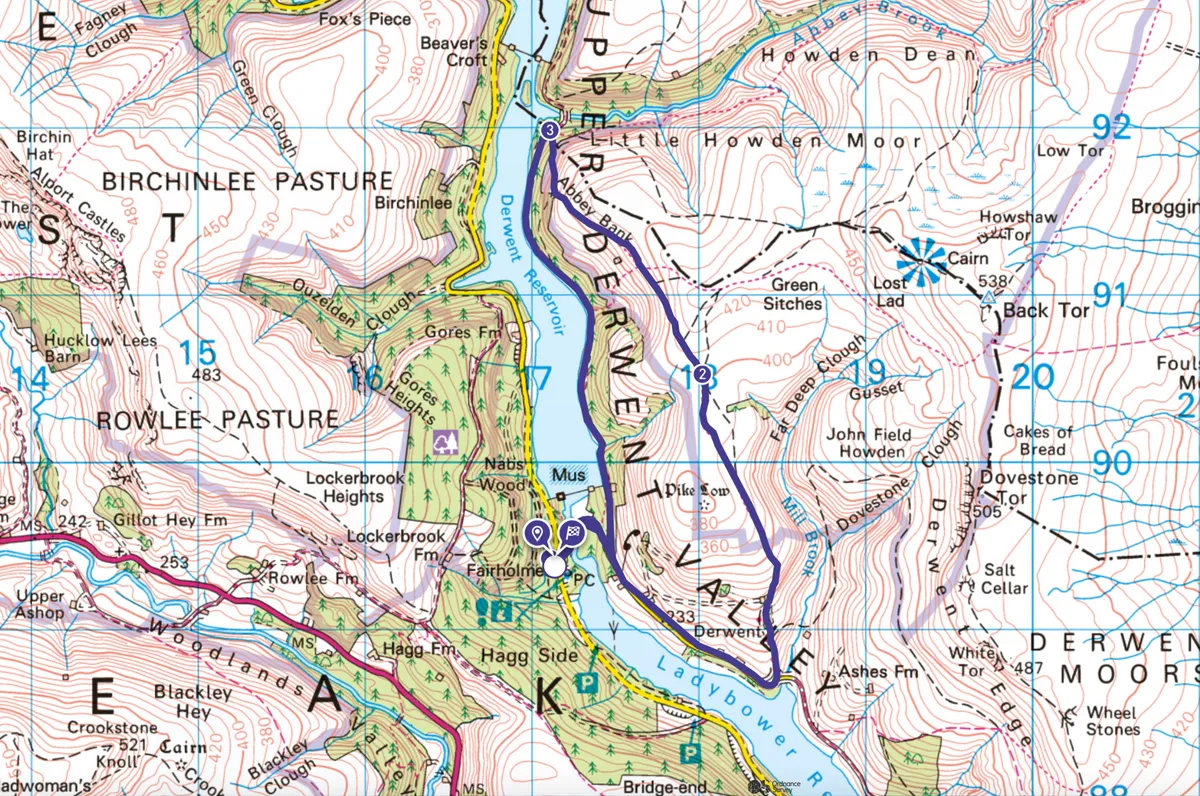
Get a taste of the Dambusters’ practice ground with an easy six-mile walk above and round the Derwent Reservoir, with glimpses of the still waters that once echoed to the throb of the low-flying Lancs.

Derwent Reservoir walk
5.8 miles/9.3km | 232m accent | 3.5 hours | moderate
1. Drowned village
The route from the Fairholmes Visitor Centre and café under the wall of the Derwent Dam takes you through what’s left of the former village of Derwent, most of which was demolished and submerged under the waters of the larger Ladybower Reservoir, constructed between 1935 and 1945.
Looking for more walking inspiration?

2. Bronze burials
For spectacular views of the Derwent Dam and surrounding hills stride up to Pike Low’s 508m peak, past a Bronze Age burial mound.

3. Still shores
Drop down Abbey Bank, with the wall of the Howden Dam lying ahead, and then back to Fairholmes along the peaceful, conifer-cloaked shores of the Derwent Reservoir.
Derwent Reservoir and Ladybower Reservoir Map
Derwent Reservoir and Ladybower Reservoir walking route and map