Located in the ancient district of Ardudwy, between the stunning estuaries of the Mawddach and Glaslyn, is the town of Harlech, famed for its dramatically positioned castle on a rock.
Superb views stride out from the medieval fortress over a shimmering sea to the rocky hills of the Llŷn Peninsula and the lofty peaks of Snowdonia. Harlech Castle – built in the late 13th century to consolidate Edward I’s control of Wales – was designed by Savoy architect Master James of St George. In 1404 it was captured by Welsh rebel Owain Glyndwr and held for five years. It also saw action in the Wars of the Roses and the English Civil War.
High above the castle and town, a Bronze Age trackway runs through a magical landscape, disturbed only by the mewing of buzzards and the song of the skylark. Choose a fine, clear day during a dry spell and follow this peaceful, linear walk towards Bryn Cader Faner, a striking Bronze Age cairn set in the wild foothills of the Rhinog mountains.

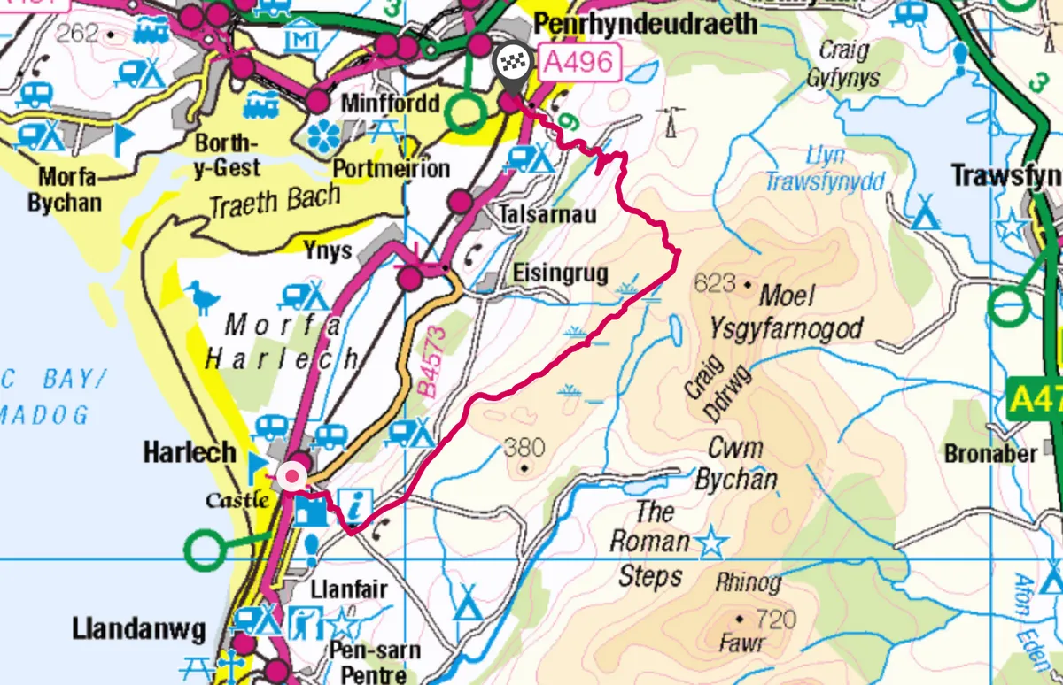
Harlech and Moel Goedog walk
9.5 miles | 5-6 hours | moderate
1. Above the towers
From the castle, walk up to a crossroads, then follow the steep, winding lane to a second crossroads high above the coastal plain. Turn left and look out for a pointed standing stone on the right, one of several marking the Bronze Age route to the Moel Goedog hill fort.
Ignore a lane on the right and, at a cattle grid, you’ll see a tall standing stone on the left below Foel Senigl. After half a mile, look out for a footpath signpost on the right and follow the track for a few yards to a right bend. Here, stay left to go through a gate. You’ll pass a massive standing stone before arriving at a point between two stone circles on the lower slopes of Moel Goedog. From here, there are wide views of the Dwyryd estuary, Llŷn Peninsula and the mountains to the north.

2. Crown of thorns
Continue north-east through gates, ignoring a track on the right to hidden Llyn y Fedw. After two stiles and a right bend, climb a stile on the left. The walk now follows the waymarked Ardudwy Way as far as Llyn Tecwyn Isaf.
Go ahead to join a track, turn right, climb two stiles and turn left on a waymarked path. The Bronze Age trackway now passes through a wild upland landscape of rocks, reeds and cairn remains. As the track bends north, Bryn Cader Faner – one of the most distinctive Bronze Age monuments in Britain – appears ahead. Note the waymarked track on your left just before the site (this will be your descent route), and then ascend a slight hill to a heap of jagged rocks.
The small cairn, probably the burial site of a significant person, is edged with thin stone slabs set at an angle like the rays of the sun. It was used by the army as target practice before WWII, losing some of its stones on the east side, but the cairn has kept its impressive silhouette.
3. Beyond the llyn
Descend to the waymarked track and follow the trail through bog and over small footbridges. Pass below the rocky hill of Y Gyrn and then veer right to emerge on to a lane. Turn left to another lane, then go right and left to the pretty waters of Llyn Tecwyn Isaf. Ignore a lane on the right and go left to Bryn Bwbach, then turn right downhill to the A496.
The bus stop for Harlech is on the left in Cilfor, while Llandecwyn station is ahead beside the Dwyryd estuary. Be sure to check bus and rail times from Llandecwyn before you set out on your walk. There are ample lodgings and refreshments back in Harlech. but none on the trail.
Harlech and Moel Goedog map
Harlech and Moel Goedog walking route and map