Although only five and a half miles separate Lizard Point from Mullion Cove, this great Cornish ramble takes rather longer than you might expect.
From the map it looks very simple – just follow the South West Coast Path along the sea’s edge – but what is not so obvious is that this is a path that switchbacks its way along the cliffs: every little inlet means a scramble down one side and an often steep climb up the other.
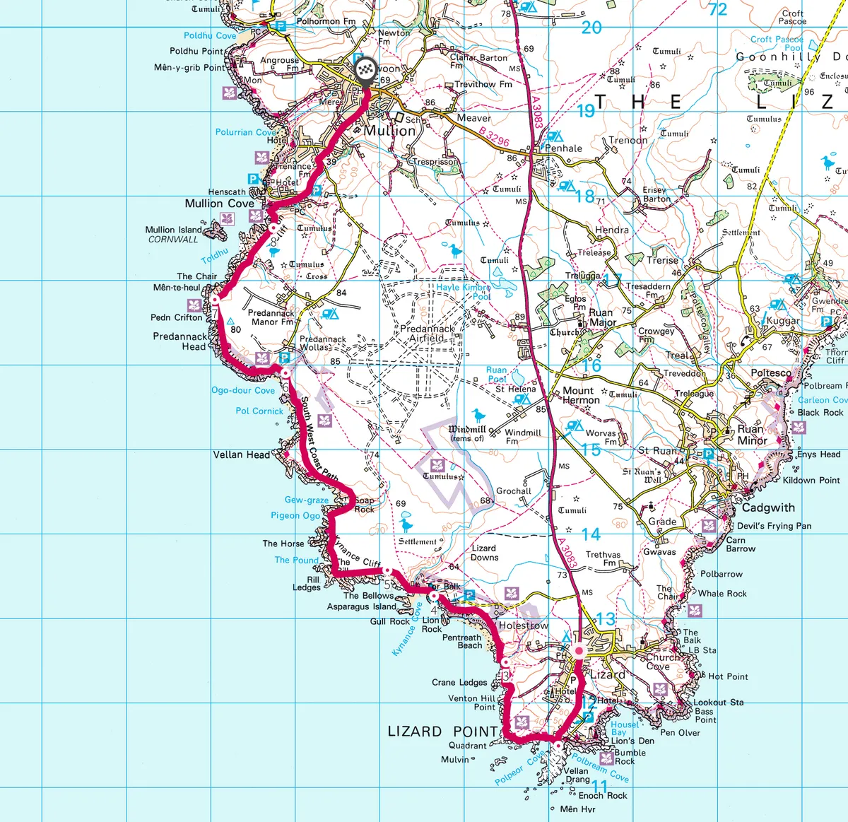
Follow our walking route from Lizard Point to Mullion Cove in Cornwall.

One minute you are striding comfortably over turf and heather on a cliff top, with gulls sailing by effortlessly riding the wind: the next you are down on a beach with the waves crashing on the rocks.
But it is all more than worth it for the rich sensory variety of the walk and the magnificent cliff scenery you will enjoy for every yard of the way.
You may also like
Spring is one of the great times to walk this route, particularly after a mild winter when everything comes into bloom a lot earlier. And this is an area noted for its flora. As well as the familiar cliff top plants that so often nestle among the rocks, such as the delicate white and pink of sea campion and thrift, you can also enjoy the brilliant bursts of yellow of prostrate broom. This is a colourful walk in every sense of the word.

1. Wild rocks
The walk starts at the car park immediately south of the village of Lizard itself. From here a short path takes you out to the end of the Point that ends in a ridge of jagged rocks, pushing out into the sea.
2. No more land
This is the most southerly point in mainland Britain, but the land doesn’t give way without a struggle – a scatter of rocks shows above the waves. Over to the left, the twin towers of the lighthouse rise up as a prominent landmark.
From the end of the roadway from the car park, turn right to join the coastal path that stays close to the sea’s edge for the rest of the way.
3. Caerthillion Cove
At first you stay comfortably on the cliff top, but it is not long before the first inlet drops down to a little cove, with rock ridges that send the spray flying on rough days.

4. Kynance Cove
A short way beyond that is Kynance Cove, one of the most spectacularly beautiful of all the Cornish coves. Even on a cloudy day, when the sea is a sullen grey, the water in the sheltered cove is the sort of turquoise blue you expect to find round a Pacific island, not off the coast of Cornwall. The path comes down to a sandy beach dotted with rocks smoothed by the sea to rounded, purplish lumps like a pile of oversized kidneys on some giant butcher’s slab. The beach itself is almost encircled by rocks, like the ramparts of a fortified harbour, with towers and spires. Linger here before heading back up to the cliffs.
5. Coastal grazers
The path hugs the cliff top, and the vegetation along the way is kept under control in the most natural way possible, by grazing animals. Some, such as the Dartmoor ponies, have not travelled too far to reach their new home, but it comes as a bit of a shock to find Highland cattle on a Cornish cliff.

You may also spot the bird that features on the Cornish coat of arms, but which until recently was very rare in these parts, the chough. It is a large crow with red legs and a distinctive curved red bill.
6. Caves
Pass the mysterious caves and trickling waterfalls of Ogo-Dour and Parc Bean Coves. The path remains level, allowing plenty of time to take in the scenery, before Mullion Island comes into sight.

7. Island
The island was formed by volcanic action millions of years ago, when molten lava bubbled up from deep in the earth and solidified upon reaching the cold waters of the sea.
8. Fishing tradition
There is a steep descent to the little harbour of Mullion Cove, built in the 1890s by local landowner Lord Robartes, largely to provide a safe haven for the local fishermen. Stout stone walls line the harbour, and a pier curls round, still used by a few fishermen following a centuries old tradition of setting out pots for crab and lobster.

There is a small, welcoming café near the harbour, before the final part of the walk leaves the sea behind and turns inland up the road into Mullion village.
9. Mullion it over
The Old Inn is a traditional thatched pub, an ideal place to celebrate the end of the walk, with real ales and fresh local fish. While in the village, visit the 13th-century church, which has an elaborate rood screen.
Keep eyes peeled for the dog flap in the front door, which allowed sheep dogs to come into the church. Catch a bus from the village to Helston and from there back to the Lizard.
Map