The lively and attractive town of Wadebridge stands on the banks of the River Camel, a few miles east of Padstow on Cornwall’s glorious north coast.
It was designated a market town in 1312 when it was known simply as Wade (Old English for Ford) with the suffix added when a stone bridge was built in the 15th century.
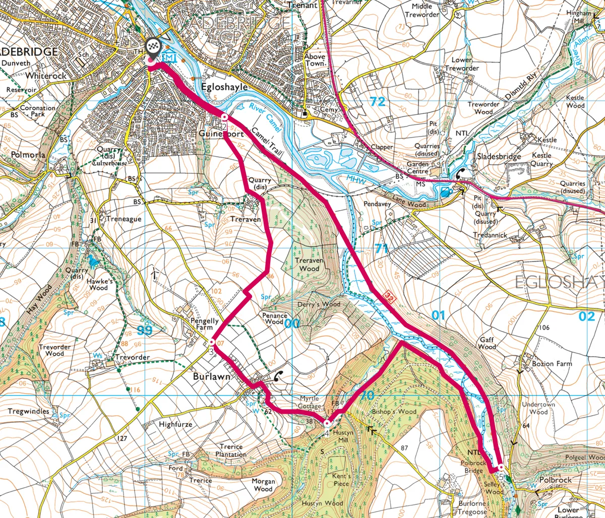
Follow our easy walking route starting at Wadebridge and exploring the surrounding Cornish countryside.

Cargo ships used to moor on the river and played a significant role in the early prosperity of the town. When the Wadebridge and Bodmin Railway Line opened in 1834, it was the first to carry passengers in west Britain and opened Wadebridge up to the tourist boom of the period. It remains a popular destination all year round with an excellent selection of independent shops, selling locally sourced produce, gifts and crafts. There are also several welcoming pubs and restaurants offering hearty grub and excellent accommodation, where a comfortable night’s sleep can be had after spending the day discovering Wadebridge and walking a section of the Camel Trail – which, on a cold, crisp winter’s, day is hard to beat.

1. Start the trail
Facing the Town Hall on The Platt turn left. At a roundabout go left again on to Jubilee Road and sweep right on to Southern Way. Follow this on to Guineaport Road to reach the start of the Camel Trail.
2. Through the woods
Don’t join the trail, but keep straight following a track for Treraven. Climb steadily through a gate on to a field path, which continues through another gate on to a woodland path. At a crossroads turn left, where a track sweeps right on to a path. When it splits, keep right past a house and continue south through another gate. Just before another gate turn left then right to a minor road beside a house. Go straight on and turn left to the quiet village of Burlawn.

3. Past the village
Descend through Burlawn. The road curves left past Gamekeepers Cottage and Hustyn Mill. Beyond a bridge ignore a footpath on the left and take the next left to tranquil Bishop’s Wood.
4. Follow the river
A broad track heads north-east then southeast alongside the River Camel. At a junction go left and keep on. Beyond a car park turn left to cross Polbrock Bridge over the river. Bear left through a gate, drop down through another gate and turn left onto the Camel Trail.
5. Back to wadebridge
Follow the riverbank track back to Wadebridge.
Map