In England there are an astonishing 68 county tripoints, but perhaps none as lovely as Three Shires Head where Staffordshire, Derbyshire and Cheshire converge in an isolated Peak District valley.
Here, two bridges span the meeting of waters, a duo of waterfalls cascading over rocks to gather in mountain-cold plunge pools. Hikers, photographers and wild swimmers are all drawn to this beauty spot, so it’s best to come early in the day. Enjoy an invigorating swim, a hot drink and the first rays of the summer sun before continuing on your figure-of-eight hike.
In the nesting season, the plaintive cries of curlew are a constant soundtrack above the upland streams, while the surrounding moorlands are splashed with purple heather towards summer’s end.
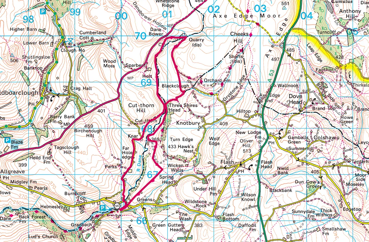
Three Shires Head walk
6.2 miles/10km | 4 hours | moderate
1. Start
From the back of the Wildlife Trust car park in the mill hamlet of Gradbach in Staffordshire, head along the waterside path. Go through the wall gap on to the lane, immediately crossing a footbridge to cut across to the Flash road. Turn right, then left into Dane View House drive. A signboard points you through a field gate. Continue over a series of fields, then follow the metal sign north-west for the three counties tripoint.
2. Tripoint time
Drop down the wide grassy path, then gravel farm track. Turn left past farm outbuildings before veering right to climb the stony path above the River Dane to Three Shires Head. Submerge yourself in the freezing water – painful but wonderfully reenergising. Once you’re dry and warm, drink in the watery scene with its lovely packhorse bridge. It once carried a valuable trading route – the Peak’s very own Silk Road.
3. Moorland meander
Go through the gate to the right of the bridge and follow the brook upwards through the moorlands of Derbyshire. Continue to a fingerpost where slabs cross the track. Turn left, backtracking initially to follow a broad grassy path up on to the moorlands.
Reaching a metal gate, turn left again to follow the Dane Valley Way as far as Reeve Edge and Danebower quarries, an atmospheric place of peaty water, spoil heaps and ruined drystone huts.
4. Hut to hamlet
Cross the brook’s stepping stones into Cheshire and climb the hill past a round hut and quarry pond. Look out for a narrow left-hand path that leaves the broad track to drop to the stream, which winds its way back to Three Shires Head. At the tripoint, climb the stony track, keeping the River Dane on your left, and look out for a footpath cutting down through fields to the hamlet of Knar.
5. High vista
Follow the quiet gated lane west and south, savouring the wide-reaching views to Ramshaw Rocks and The Roaches. A left-hand path, immediately after the second road gate, descends through gorse to the Flash road. Turn left to cross the bridge, then retrace your steps to the car park.
Three Shires Head map
Three Shires Head walking route and map