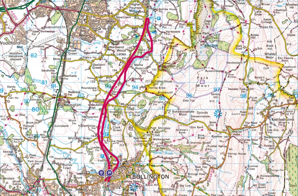
The Cheshire Plain ends abruptly in a jumble of ridges and knolls that rise steeply into the Peak District. Threading along this divide are two contemporary transport arteries that today offer some idyllic, easy cycling in glorious wildflower-rich countryside – a mosaic of woodlands, cloughs and pastureland rich with industrial heritage.
At its heart is trendy Bollington, which grew as a cotton town in late Georgian times, booming after the Macclesfield Canal opened in 1831. Huge mills developed beside this waterway curving above the town. The imposing Clarence Mill stands at one end of a remarkable embankment and aqueduct, one of the most notable achievements of Britain’s canal builders.

A little downhill from this is a curving viaduct, which until 1970 carried the Macclesfield to Marple railway across the River Dean. This line opened in 1869, a purported successor to the limited capacity of the canal, although both thrived together for many decades. This ride – 99% off-road – makes the most of both these historic routes.
Middlewood Way and Macclesfield Canal bike ride
8.6 miles/13.8km | 2 hours (cycle)/5–6 hours (walk) | easy/moderate
1. Post office rides
The canalside cycle hire opposite Adelphi Mill rents out characterful, refurbished post-office bikes. These three-gear machines, with their front baskets and jaunty style, are ideal for this largely level route. Downhill below the canal aqueduct is the Middlewood Way cycle track, departing to your right (north) in 100m.
That’s the road section done. The old railway is well surfaced and shared as a footpath and bridleway. It soon opens out on to the memorable 23-arch viaduct, before progressing through wooded cuttings and along ledges revealing sublime views across Cheshire.
2. Pit and wharf
Higher Poynton is reached in four miles, where there is a welcome from the cosy Boars Head pub and the cute Coffee Tavern. Cross the railway bridge to the Heritage Centre at Nelson Pit, where the story of the East Cheshire Coalfield is told. Rise up the access lane to the vibrant Vernon Wharf on the Macclesfield Canal, from where the towpath (canal on the left) heads south to Bollington.
3. Distant views
One of the last canals to be built, the Macclesfield slinks through a glorious hilly landscape, easing across aqueducts bridging becks and lanes that tumble from the shapely heights; Cheshire’s highest point (Shining Tor, 559m) is just five miles away. The canal is higher than the Middlewood Way, with correspondingly better vistas. As it progresses, absorbing views encompass the Peak District’s hills, the mid-Cheshire ridge and the distant smudge of Welsh mountains. The towpath on this section has a compact surface and is well maintained.
4. To the café
An easy 4.5 miles brings you to the huge embankment at Bollington; there is a café in Clarence Mill. Adelphi Mill is a further half-mile beyond. Carry your bike down a flight of steps off the aqueduct – topped by an old stable building, now a canoe store – then rise from beneath the canal to find the hire centre.
Map
Middlewood Way and Macclesfield Canal walking route and map.