A medium difficulty circular 10-mile walking route from Llangollen to the Pontcysyllte Aqueduct.
1. Crow climb
Start at the Tea Room by Llangollen Wharf, cross the stone bridge over the canal and follow the signs uphill for Castell Dinas Bran. Go through a gate on the right with a sculpture of a black crow – the totems of Castell Dinas Bran (bran in Welsh is crow; you’ll spy these feathered guardians circling the ruins). Weave up through gorse and heather to the summit, passing hovering kestrels.
2. King of the castle
Mounting what was once a prehistoric hill fort, the stone ruins are from the short-lived Castell Dinas Bran, built in 1260 but razed in 1277. Scan the horizon to see Eglwyseg limestone escarpment off to the north, the Llantysilio Mountains to the west, the Berwyn Mountains dominating the view south and, to the east, the viaduct carrying the railway over the Dee.
Head north-east from the summit to exit Castell Dinas Bran and turn left briefly on to the road before turning right on to Panorama Walk, part of Offa’s Dyke Path. This aptly named road wends through rich limestone and spectacular views of the Dee valley.
More related content:
3. Along the aqueduct
When Pontcysyllte Aqueduct opened in 1805, Trevor Basin was transformed into a hub of narrowboats shifting coal, iron, limestone, bricks and tiles. Today it is a quieter hub of leisure boats. Here, admire the museum and walk the length of the aqueduct. Marvel at its height, the rushing river below and the narrowboats crossing the seemingly perilous waterway. Telford and Jessop’s creation is a fine structure without ostentation, just the simple elegance of engineering prowess.

4. Return crossing
Retrace your steps across the aqueduct to Trevor Wharf, following the signs for Llangollen, over the small stone bridge and onto the canal footpath.
5. Between waters
Take the canal footpath all the way back to Llangollen, a glorious flat stroll with water either side – the tranquil canal to your right, the roaring Dee on your left. Note the craggy rock from which the canal was gouged arduously by the ‘navvies’ who built it.
6. Llangollen End
You're back! If you feel wildly energetic, pass Llangollen to the Horseshoe Falls, the start of the Shropshire Grand Union Canal, where every day, 12 million gallons of water are drawn in from the River Dee to supply water to the canals. If not (and who could blame you?), end at Llangollen for well-deserved sustenance and to admire this delightful town on the Dee.
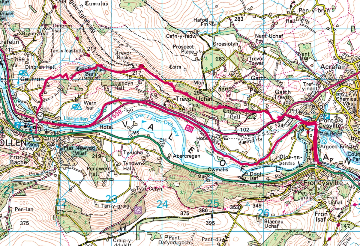
Map
Llangollen walking route and map.