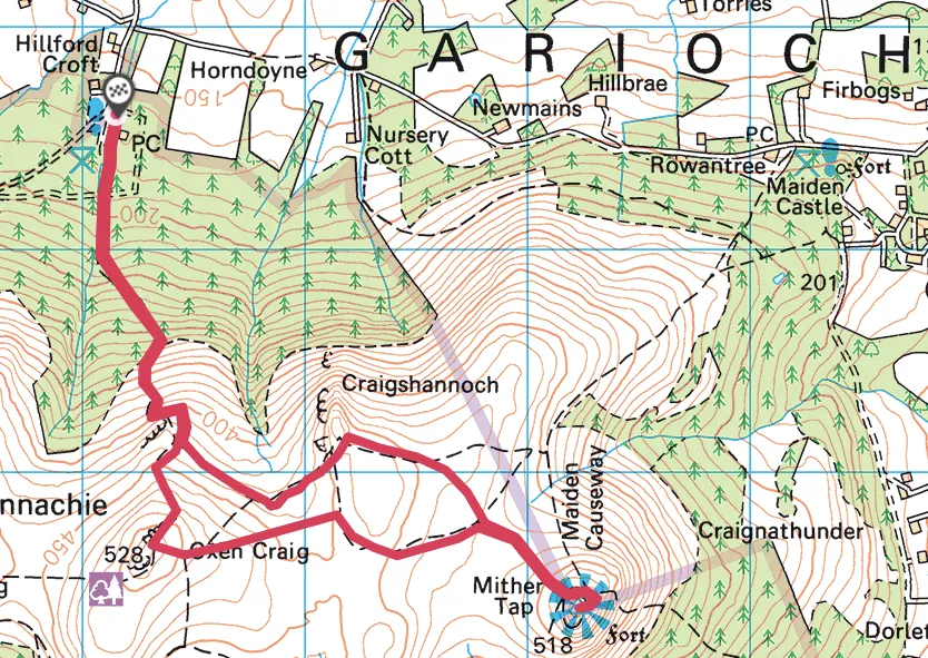
Bennachie is a prominent prospect as you travel through the hills and river valleys of Deeside, its unique profile visible for many miles around.
Rising from the flat plains of Aberdeenshire, a few miles west of Inverurie, Bennachie’s twin tops of Oxen Craig and Mither Tap grant far-reaching vistas. At 518m, Mither Tap is slightly lower than Oxen Craig (528m), but its shapely character leads to Bennachie’s Gaelic derivation ‘mountain of the breast’.

The two main tops are connected by a wild and wonderful plateau where meadow pipits, lapwings and red grouse thrive. The remains of a Pictish hill fort can also be visited.
This wonderful landscape is looked after by the Bailies of Bennachie, a conservation group formed in 1973, whose objectives include maintaining Bennachie’s paths and access to study its flora and fauna and to collect and preserve ballads, legends, poetry, art and music related to the surrounding landscape.
A 5.5-mile circular hill walk to the summit of one of Aberdeenshire's most striking ridgelines.
5.5 miles/8.9km | 3.5 hours hours | moderate
1. Up to oxen
From Back o’ Bennachie Car Park, head south to an information board and bear right into woodland following the ‘Mither Tap Quarry Trail’. An excellent path makes steady progress to a junction. Turn right then immediately left, where the path rises steeply on to Bennachie’s lower, heathery slopes with extensive views opening out over the patchwork landscape of rural Aberdeenshire. In a while, the path splits; keep left to a junction. Go right, climb over a rocky shelf then keep right at the next fork for a steady ascent on to Oxen Craig and a truly magnificent view.
2. Plateau path
Retrace your steps a few metres then bear right and descend on to Bennachie’s broad plateau. Head east, eventually reaching a fork. Keep right, then right again at the next junction. Continue south-east to the base of Mither Tap. Initially, the path ascends steadily to a fork beneath Mither Tap’s striking, northern rocky face.

3. Cairngorms view
Go left (the signed Mither Tap route points right butthis can be awkward and is best avoided) and follow the path as it passes around its eastern and then southern side and through the rubble walls of an old Pictish fort.
A final steep climb up steps gains Mither Tap’s 518m summit – again it makes for an exquisite vantage point that includes Lochnagar and the Cairngorms.
4. Descending the tap
Carefully retrace your steps back down to the fork beneath Mither Tap’s rocky face. Turn right and walk north-west, then west across the plateau to a fork beneath Craigshannoch. From here a path climbs easily to the summit.
5. Forest return
Return to the main path, go right and descend south-west, then north-west underneath Oxen Craig’s lower slopes back to the outward-bound path. Retrace your steps back down the hill and through the forest to the start.
Bennachie walking route and map