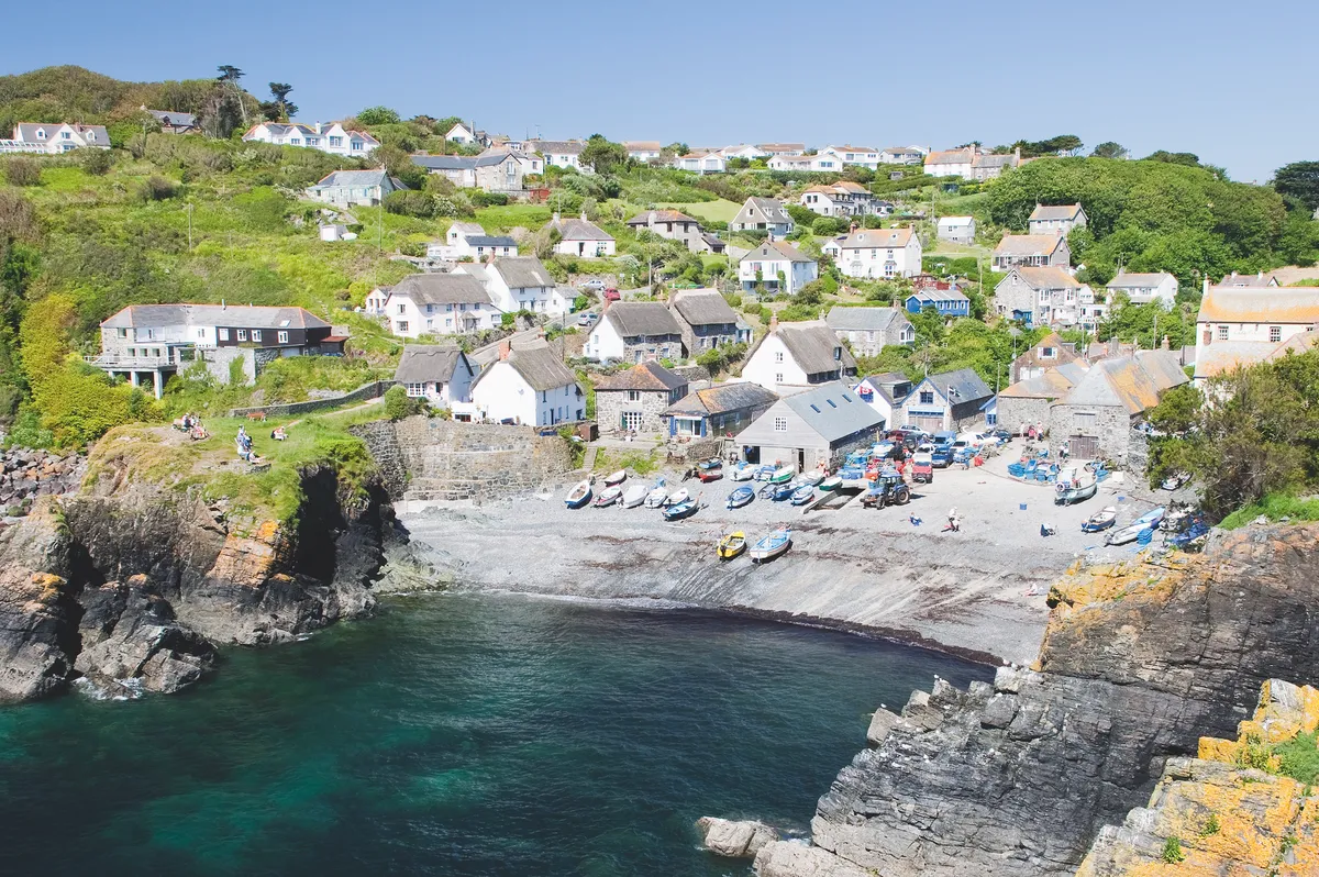
Battered by Atlantic swells on Cornwall’s Lizard Peninsula, Cadgwith is the southernmost fishing village in the UK. Thatched cottages cluster together on the slopes of the valley, while a stream runs down to the sand and across the shingle beach.
Old pilchard cellars, winches, and the former lifeboat house – active until 1963 and now home to the local gig club – are evocative reminders of the village’s colourful past.
Cadgwith was built to service the thriving pilchard industry in the late 1700s and 1800s, when huge shoals migrated to Cornish waters. At its peak, there were six pilchard companies in operation here. Lofts were used for storing nets, capstan houses for winching boats ashore, and cellars for pressing the fish to extract the oil, which was salted and baulked, and packed into ‘hogshead’ barrels.
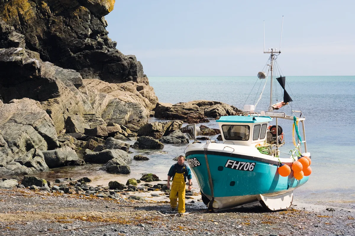
Overfishing put an end to the boom in pilchards (since renamed ‘Cornish sardines’), but today Cadgwith fishermen are renowned for their crabs and lobsters, caught in pots from August to December, and monkfish, cod, pollack, red mullet, John Dory and ling, netted all year round. Their brightly coloured boats are launched from a steep shingle beach, the most easterly of two south-east-facing beaches sat either side of a small rocky headland called the Todden.
Visiting Cadgwith
Looking over the beach, strewn with fishing boats and crab pots, is the 300-year-old Cadgwith Cove Inn, a time capsule that harks back to its smuggling history, its walls adorned with seafaring memorabilia. Curio gin, distilled in nearby Mullion, is delicious on a warm evening.
In summer, snorkellers, divers and rockpoolers enjoy the clear waters of the neighbouring beach, at the bottom of some steep steps. In the evening, people gather at the Cadgwith Cove Inn for seafood barbecues prepared by local fishermen, with proceeds going towards the village’s Christmas lights.
You may also like
The barbecues take place outside one of the historic fish lofts, which was safeguarded earlier this year by campaigning locals who successfully crowdfunded just over £300k to buy all three of the village’s lofts, used by the fishermen to store gear and process their catch. The aim is to protect the buildings from potential development and help to safeguard the future of Cadgwith’s fishing industry.
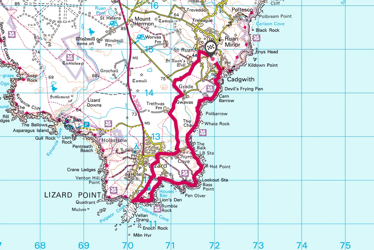
A lovely 6.5-mile circular walk follows the South West Coast Path from Cadgwith to Church Cove.
Cadgwith walk
6.5 miles/10.5km | 5–4 hours | moderate
1. Start
Start at the village car park and walk down to the shore. Join the coast path and walk south to the Devil’s Frying Pan, formed by the collapse of a sea cave, resulting in a 100-metre-deep depression. In rough weather the sea appears to be boiling, with the central boulder resembling an egg, while the pounding of waves causes an impressive blowhole.
Cross the fields and rejoin the coast path, where you’ll be directed over a stile and a bridge towards Church Cove. Close by lies Vrogue Rock, some 800 metres south-east of Bass Point. Hidden two metres beneath the surface, it has claimed many ships over the years, including the Czar in 1859, when 13 people drowned, despite the best efforts of coastguards and Cadgwith fishermen. British military buttons from the uniforms are still found by divers.

2. Ships beware
Walk over a footbridge and up steps to a field to reach Balk Beacon (the headland just before Church Cove is known as The Balk) – a distinctive red and white marker, designed to help ships avoid the notorious Vrogue Rock. Erected in 1859, it was restored in 2002 by the National Trust.
Through a kissing gate at Church Cove is the Lizard RNLI lifeboat station, built in 2012, with a funicular railway line to transport lifeboat crews from the boathouse to the 60-metre clifftop. From here you can often spot dolphins, while grey seals are regular visitors to the nearby rocks.
You can also see choughs around the peninsula, but watch out for adders, too, which are often out exploring early on summer mornings (particularly on the coast path underneath the lighthouse).
3. Magical waves
Pick up the South West Coast Path again behind the lifeboat station, and walk past the National Coastguard Lookout and on to Lloyds Signal Station, which opened in 1872 to pass messages to ships entering the English Channel. The Lizard Wireless Station is further along the track, built by Guglielmo Marconi in 1900, from where he proved that radio waves could be bent around the Earth’s surface.
A series of tracks and paths take you past the Lizard Lighthouse to Britain’s most southerly café, on Lizard Point.
4. Holy return
Return inland through fields and lanes, east of Lizard village to St Wynwallow’s Church (late-sixth or early seventh century). You’ll then pass the farmstead of Trethvas. Some 400 metres after the farm, turn left on to a country road. Look for a path on the right, opposite Anvoaze Barn, which leads to St Grada, an ancient church built of serpentine (green-hued rock)and used for the filming of Dr Who in the 1960s.
Stay left at the crosspaths to join the road at St Ruan’s Well. Turn right. Ignore two side roads on the right, then, just before a bridge, turn right through a gate back to the car park.
Cadgwith map
Cadgwith walking route and map