The cliffs at Traeth Mawr reach into the spring sky like the stepped, ivory walls of a Mayan temple. Peregrines nest upon the ledges of the tottering limestone bluffs, and choughs, the rarest members of the crow family, chee-ow and soar.
Greater knapweed, wild cabbage and knotted hedge-parsley gather in clumps on the grassy crests, while down in the valley, where the land meets the sea, common rockrose sings yellow alongside the occasional clustered bellflower or horseshoe vetch.

It’s a wild place, and as you step through the wooded valley of Cwm Nash down to the beach, it’s easy to forget that you’re just 26km (16 miles), as the crow flies, from the capital city of Wales.
Cwm Nash walk
4.5 miles | 3 hours | moderate
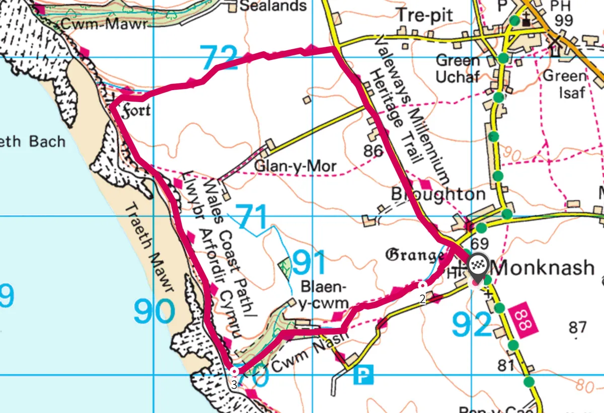
1. Monastic ways
The walk begins beside the whitewashed walls of The Plough and Harrow in Monknash. Leave the pub to the east then turn left on to Heol Las road, heading north-west between sparrow-filled hedgerows to the edge of the village. Look for a small building on the left opposite a side road and climb the stone stile beside it to enter a field.
Monknash was once the site of a monastic grange, run by monks to provide produce for the monastery at Neath. The farm was fruitful and it wasn’t long before auxiliary buildings began to rise from the turf: a forge, tithe barn, dovecote and animal shelters. The remains of the grange can still be seen today, masquerading as trees beneath heaps of tangled brambles and ivy.
2. Beech to beach
After crossing several fields and stone stiles, you’ll arrive at Nash Brook. Negotiate the makeshift ford and continue on the right-hand side of the water for about half a mile to a wooden bridge with stone steps. Cross back to the south side of the brook and follow the path alongside a scrubby hedge to a small road. Turn left and shortly after right, entering the steep-sided, river-cut vale of Cwm Nash.

The path twists and dips through soaring beech trees; their branches draped with vines and their roots a bed of moss, fungi and hart’s tongue ferns. Descending, the rhythm of the river becomes stronger, the smell of earth more potent, and soon you arrive at the ruins of a water mill, its crumbling gable wall and door woven with white-water cascades.
Shortly after, the trees yield to a mass of gnarled blackthorn and almond-scented gorse, then the river breaks from the scrub and spills out across a series of shallow platforms into the Bristol Channel. Huge Lego-like cliffs rise to the north and south. On a windy day, the lumbering surf slumps hard on to the shore, rumbling like thunder across the boulders on its retreat to the sea.
Wildlife highlight: common periwinkle
The largest of the species, common periwinkles have an average diameter of 5cm. The mollusc has a conical, spiralling shell and ranges in colour from grey to black, brown or red.
3. Cwm to clifftop
Turn north on the Wales Coast Path and climb steeply to a small stone shelter. For the next mile or so the route sticks to the clifftops, before veering right along the edge of Cwm Bach. At the head of the small valley, turn left down steps then shortly after turn right, crossing a farm track and a large field. Continue with your easterly trajectory for half a mile, entering a tunnel of hawthorn trees, brambles and ivy. When you meet a country road, turn right and, taking care of traffic, walk between hedgerows for about a mile back to Monknash and its pleasant inn.
Traeth Mawr map
Cwm Nash walking route and map